Llandenny

Last updated

Llandenny
Llandenny Church in winter sunshine - with sunshine roof^ - geograph.org.uk - 1122845.jpg
The Church of St John the Apostle and Evangelist, Llandenny (during the restoration of its roof)
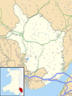
Monmouthshire UK location map.svg
Red pog.svg
Llandenny
Location within Monmouthshire
OS grid reference SO415038
Principal area
Preserved county
Country Wales
Sovereign state United Kingdom
Post town USK
Postcode district NP15
Dialling code 01291
Police Gwent
Fire South Wales
Ambulance Welsh
UK Parliament
Senedd Cymru – Welsh Parliament
List of places
UK
Wales
Monmouthshire
51°43′50″N2°50′54″W / 51.7306°N 2.8482°W / 51.7306; -2.8482

Llandenny (Welsh : Llandenni or, lesser used, Mathenni) is a village in Monmouthshire, south east Wales. Llandenny is located three miles south of Raglan and three miles north of Usk. [1]
Contents

History and amenities

The little village of Llandenny is just a few houses, a pub (the Raglan Arms - closed) and the Church of St John, named after St John the Apostle and Evangelist. The main south Wales to the Midlands road link, the A449, passes close to the village.

The Raglan Arms was named for Lord Raglan who owned the nearby Cefn Tilla Court until it was sold in 2015, following the death of Fitzroy Somerset in 2010. A landlord of the pub in the 1930s was Frank Wake who catered nearly always for the farm labourers and not the gentry so it became a 'thorn in the flesh' of the Raglan family.

The nearby Llandenny railway station building (photographed) existed for many years until it was converted into a residential property. It included a ground frame signal box on the platform, a cattle dock and small goods sidings. It stood on the Coleford, Monmouth, Usk and Pontypool Railway line and closed in 1959.

Raglan Arms in Llandenny - geograph.org.uk - 968188.jpg
The Raglan Arms
Railway at Llandenny.jpg
The disused railway station

Notes

  1. "Llanddenni / Llandenny, Monmouthshire". The National Gazetteer of Great Britain and Ireland. genuki.org.uk. 1868. Retrieved 13 March 2012.

Commons-logo.svg Media related to Llandenny at Wikimedia Commons


Related Research Articles

<span class="mw-page-title-main">Abergavenny</span> Market town in Monmouthshire, Wales

Abergavenny is a market town and community in Monmouthshire, Wales. Abergavenny is promoted as a Gateway to Wales; it is approximately 6 miles (10 km) from the border with England and is located where the A40 trunk road and the recently upgraded A465 Heads of the Valleys road meet.

<span class="mw-page-title-main">Usk</span> Town in Monmouthshire, Wales

Usk is a town and community in Monmouthshire, Wales, 10 miles (16 km) northeast of Newport. It is located on the River Usk, which is spanned by an arched stone bridge at the western entrance to the town. Usk Castle, above the town, overlooks the ancient crossing point. It developed as a small market town, with some industry including the making of Japanware, and with a notable prison built in 1841–42. In recent years Usk has become known for its history of success in Britain in Bloom competitions, winning the "Wales in Bloom" competition for 35 times in a row between 1982 and 2016. The resident population of the town in 2011 was 2,834, decreasing to roughly 2,600 in 2021. 6.8% of the population are recorded as being able to speak Welsh.

<span class="mw-page-title-main">Llandogo</span> Human settlement in Wales

Llandogo is a small village in Monmouthshire, south Wales, between Monmouth and Chepstow in the lower reaches of the Wye Valley AONB, two miles north of Tintern. It is set on a steep hillside overlooking the River Wye and across into the Forest of Dean in Gloucestershire, England. The 2011 census population was 547.

<span class="mw-page-title-main">Llanvair Discoed</span> Human settlement in Wales

Llanvair Discoed is a small village in Monmouthshire, south-east Wales, 6 miles west of Chepstow and 10 miles east of Newport.

<span class="mw-page-title-main">Raglan, Monmouthshire</span> Village in Monmouthshire, Wales

Raglan (; is a village and community in Monmouthshire, south east Wales, United Kingdom. It is located some 9 miles south-west of Monmouth, midway between Monmouth and Abergavenny on the A40 road very near to the junction with the A449 road. The fame of the village derives from Raglan Castle, built for William ap Thomas and now maintained by Cadw. The community includes the villages of Llandenny and Pen-y-clawdd. Raglan itself has a population of 1,183.

<span class="mw-page-title-main">Llangynidr</span> Village and community in Powys, Wales

Llangynidr is a village, community and electoral ward in Powys, Wales, about 4 miles (6.4 km) west of Crickhowell and 9 miles (14.5 km) south-east of Brecon. The River Usk flows through the village as does the Monmouthshire and Brecon Canal. It is in the historic county of Brecknockshire.

<span class="mw-page-title-main">Bettws Newydd</span> Village in Monmouthshire, Wales

Bettws Newydd is a small village in Monmouthshire, in southeast Wales located about 3+12 miles (5.6 km) north of Usk, a few miles south of Clytha near Raglan, Monmouthshire.

<span class="mw-page-title-main">Llanvihangel Gobion</span>

Llanfihangel Gobion is a village and rural parish of Monmouthshire, Wales, lying within the administrative community of Llanover.

Bryngwyn is a village and rural location in Monmouthshire, south east Wales.

<span class="mw-page-title-main">Mitchel Troy</span> Human settlement in Wales

Mitchel Troy is a village and community in Monmouthshire, south east Wales, in the United Kingdom. It is located 3 miles south west of the county town of Monmouth, just off the A40 road leading towards Raglan. Settlements within the community include Tregare, Dingestow, Cwmcarvan and Wonastow.

<span class="mw-page-title-main">Llanellen</span> Human settlement in Wales

Llanellen is a village in Monmouthshire, south-east Wales, United Kingdom. It is located three miles (4.8 km) south of Abergavenny. The population was 506 in 2011.

Monkswood is a village in Monmouthshire, south east Wales, United Kingdom.

<span class="mw-page-title-main">Pen-y-clawdd</span> Human settlement in Wales

Pen-y-clawdd is a village in Monmouthshire, south east Wales, situated between Raglan and Monmouth. The village is the site of a medieval fortification and there is a historic church with an ancient cross in the churchyard which is a scheduled monument.

<span class="mw-page-title-main">Gwernesney</span>

Gwernesney is a village in Monmouthshire in southeast Wales.

Gwehelog is a village settlement in the community of Llanarth, in Monmouthshire, south east Wales.

Llanfihangel Tor-y-Mynydd is a small rural village in the community of Devauden, Monmouthshire, Wales. It is located within the Vale of Usk, about 9 miles south west of Monmouth and 6 miles east of the town of Usk, between the villages of Devauden and Llansoy.

<span class="mw-page-title-main">Coleford, Monmouth, Usk and Pontypool Railway</span> Railway in Monmouthshire, Wales

The Coleford, Monmouth, Usk & Pontypool Railway (CMU&PR) was a standard gauge railway of 16 miles (26 km) which ran from Monmouth to Little Mill, near Pontypool in Monmouthshire, Wales. It was intended to convey the mineral products of the Forest of Dean to the ironworks of South Wales, by connecting to the Newport, Abergavenny and Hereford Railway at Little Mill Junction. The NAHR made the onward connection over its Taff Vale Extension line. The CMU&PR intended to acquire the Monmouth Railway, actually a horse-operated plateway, and convert it to locomotive operation.

<span class="mw-page-title-main">Raglan railway station</span> Former railway station in Wales

Raglan railway station was a station on the Coleford, Monmouth, Usk and Pontypool Railway. It was not opened when the line was originally built, but constructed in 1876 to replace two previous stopping places, Raglan Footpath, a small station which was situated a little further west, and Raglan Road, an unofficial halt which closed in July 1876 and was reopened as 'Raglan Road Crossing Halt' in November 1930 by the Great Western Railway. The station was 6 miles and 34 chains from Monmouth Troy and was intended to improve the railway facilities at the nearby village of Raglan, which was the site a large castle which provided a steady stream of tourist traffic. It was closed in May 1955 due to a train drivers strike and was never reopened though a couple of special services continued to run along the stretch of track over the next few years, including a centenary special organised by the Stephenson Locomotive Society in 1957.

<span class="mw-page-title-main">Cefntilla Court</span> House in Llandenny, Monmouthshire

Cefn Tilla Court, Llandenny, Monmouthshire, Wales, is a country house dating from the mid-19th century. Its origins date from 1616. During the English Civil War, the court was the headquarters of Thomas Fairfax during the siege of Raglan Castle and the terms of the castle's surrender were signed at the house in 1646. By the early 19th century, the court was derelict. In 1856 it was sold by Crawshay Bailey to the Memorial Committee established to commemorate the life of FitzRoy Somerset, 1st Baron Raglan, British commander during the Crimean War. The house was completely rebuilt by Thomas Henry Wyatt and donated to Lord Raglan's heir, Richard Somerset as a memorial to his father. The house is a Grade II* listed building.

<span class="mw-page-title-main">St John's Church, Llandenny</span> Church in Monmouthshire, Wales

The Church of St John is the parish church of Llandenny, Monmouthshire, Wales. It is in the Perpendicular style and is a Grade I listed building as of 27 November 1953.