Newchurch, Monmouthshire

Last updated

Newchurch
  • Welsh: Yr Eglwys Newydd ar y Cefn
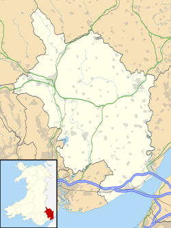
Monmouthshire UK location map.svg
Red pog.svg
Newchurch
Location within Monmouthshire
OS grid reference ST454976
Principal area
Preserved county
Country Wales
Sovereign state United Kingdom
Post town CHEPSTOW
Postcode district NP16
Dialling code 01291
Police Gwent
Fire South Wales
Ambulance Welsh
UK Parliament
List of places
UK
Wales
Monmouthshire
51°40′29″N2°47′22″W / 51.67460°N 2.78958°W / 51.67460; -2.78958
St Peter's Church, Newchurch, rebuilt from 1863-4 Newchurch church (geograph 3187194).jpg
St Peter's Church, Newchurch, rebuilt from 1863-4

Newchurch (Welsh : Yr Eglwys Newydd ar y Cefn, meaning "new church on the ridge") is an extensive rural parish and small hamlet in Monmouthshire, south east Wales. It is located 6 miles south east of Usk and 6 miles north west of Chepstow, between the B4235 and B4293 roads.

Contents

History and amenities

Before the Norman conquest of south-east Wales, the area was heavily forested as part of Wentwood. There is a Neolithic dolmen or burial chamber at Gaer-llwyd, 1 mile south west of the village close to the B4235.

In the early 12th century the Newchurch area was known as Plataland and was given by the Marcher lord of Striguil, or Chepstow, to Tintern Abbey. The monks cleared much of the land for farming, but in 1302 exchanged it with Roger Bigod, Earl of Norfolk, for land at Woolaston in what is now Gloucestershire. [1] The parish still contains much of Wentwood and also, to the east, Chepstow Park Wood south of Devauden.

Bigod built a church for the tenants of his land, which became known as Newchurch. The parish church is dedicated to St. Peter. It has some 14th-century features but was largely rebuilt around 1865. [2]

The modern hamlet consists of little more than the church, three houses and a farm.

Cas Troggy

Cas (or Castell) Troggy is a small ruined fortified hunting lodge or manor house built by Roger Bigod around 1303. It is located within Newchurch parish, beside the Troggy (or Castrogi) Brook and the old road between Chepstow and Usk, on the northern slopes of Wentwood at Pen y cae-mawr. It was probably abandoned shortly after Bigod's death in 1306. [3] [4] The 16th century antiquarian William Camden incorrectly referred to the ruins as Striguil, a mistake repeated on some later maps.

Related Research Articles

<span class="mw-page-title-main">Chepstow</span> Town in Monmouthshire, Wales

Chepstow is a town and community in Monmouthshire, Wales, adjoining the border with Gloucestershire, England. It is located on the tidal River Wye, about 2 miles (3 km) above its confluence with the River Severn, and adjoining the western end of the Severn Bridge. It is the easternmost settlement in Wales, situated 16 miles (26 km) east of Newport, 28 miles (45 km) east-northeast of Cardiff, 18 miles (29 km) northwest of Bristol and 110 miles (180 km) west of London.

<span class="mw-page-title-main">Monmouthshire</span> County in Wales

Monmouthshire is a county in the south east of Wales. It borders Powys to the north; the English counties of Herefordshire and Gloucestershire to the north and east; the Severn Estuary to the south, and Torfaen, Newport and Blaenau Gwent to the west. The largest town is Abergavenny, and the administrative centre is Usk.

<span class="mw-page-title-main">Chepstow Castle</span> Castle in Chepstow, Monmouthshire, Wales

Chepstow Castle at Chepstow, Monmouthshire, Wales, is the oldest surviving post-Roman stone fortification in Britain. Located above cliffs on the River Wye, construction began in 1067 under the instruction of the Norman Lord William FitzOsbern. Originally known as Striguil, it was the southernmost of a chain of castles built in the Welsh Marches, and with its attached lordship took the name of the adjoining market town in about the 14th century.

<span class="mw-page-title-main">Itton</span> Human settlement in Wales

Itton, is a small village in Monmouthshire, south-east Wales, in the community of Devauden about 3 miles (4.8 km) north-west of Chepstow. The village covers about a 2-mile (3.2 km) radius, with about 70 properties across a rural area. The parish also includes the hamlet of Howick.

<span class="mw-page-title-main">Caldicot Hundred</span> Ancient hundred of Monmouthshire, Wales

Caldicot was an ancient hundred of Monmouthshire, Wales.

<span class="mw-page-title-main">St Brides Netherwent</span> Village in Monmouthshire, Wales

St Brides Netherwent is a parish and largely deserted village in Monmouthshire, south-east Wales. It is centred 2 miles north of Magor, and 3 miles west of Caerwent. The A48 Newport to Chepstow road passes close by to the north.

<span class="mw-page-title-main">Llanvair Discoed</span> Human settlement in Wales

Llanvair Discoed is a small village in Monmouthshire, south-east Wales, 6 miles west of Chepstow and 10 miles east of Newport.

<span class="mw-page-title-main">Raglan, Monmouthshire</span> Village in Monmouthshire, Wales

Raglan (; is a village and community in Monmouthshire, south-east Wales, United Kingdom. It is located some 9 miles south-west of Monmouth, midway between Monmouth and Abergavenny on the A40 road very near to the junction with the A449 road. It is the location of Raglan Castle, built for William ap Thomas and now maintained by Cadw. The community includes the villages of Llandenny and Pen-y-clawdd. Raglan itself has a population of 1,183.

Striguil or Strigoil is the name that was used from the 11th century until the late 14th century for the port and Norman castle of Chepstow, on the Welsh side of the River Wye which forms the boundary with England. The name was also applied to the Marcher lordship which controlled the area in the period between the Norman conquest and the formation of Monmouthshire under the Laws in Wales Acts 1535–1542.

Wentwood, in Monmouthshire, South Wales, is a forested area of hills, rising to 1,014 feet (309 m) above sea level. It is located to the northeast of, and partly within the boundaries of, the city of Newport.

<span class="mw-page-title-main">Devauden</span> Village in Wales

Devauden is a village and community in Monmouthshire, southeast Wales. It is located between Chepstow and Monmouth near the top of the Trellech ridge on the B4293 road. The community covers an area of 3,790 hectares (14.6 sq mi), and includes the villages of Itton and Wolvesnewton, Llanfihangel-tor-y-mynydd and Newchurch.

<span class="mw-page-title-main">Wolvesnewton</span> Village in Monmouthshire, Wales

Wolvesnewton is a small village in Monmouthshire, Wales.

<span class="mw-page-title-main">Tredunnock</span> Village in Monmouthshire, Wales

Tredunnock is a small village in Monmouthshire, south east Wales, in the United Kingdom. Tredunnock is located four miles (6.4 km) northeast of Caerleon and four miles south of Usk.

<span class="mw-page-title-main">Llangwm, Monmouthshire</span> Human settlement in Wales

Llangwm is a small rural village and former community, now in the community of Llantrisant Fawr, in Monmouthshire, south east Wales. It is located 3 miles (4.8 km) east of Usk, on the B4235 Chepstow to Usk road. The main village is at Llangwm Uchaf, with a smaller and more dispersed settlement about 1 mile (1.6 km) to the north-east at Llangwm Isaf .The other settlement in the community is Llansoy. In 2022 the community was abolished and merged with Llantrisant Fawr.

<span class="mw-page-title-main">Llantrisant, Monmouthshire</span>

Llantrisant is a village in Monmouthshire, south east Wales, United Kingdom. The community population at the 2011 census was 475.

<span class="mw-page-title-main">Gwernesney</span>

Gwernesney is a village in Monmouthshire in southeast Wales.

<span class="mw-page-title-main">St Pierre, Monmouthshire</span> Human settlement in Wales

St Pierre is a former parish and hamlet in Monmouthshire, south east Wales, 3 miles (4.8 km) south west of Chepstow and adjacent to the Severn Estuary. It is now the site of a large golf and country club, the Marriott St Pierre Hotel & Country Club, which was previously a large manor house and deer park belonging to the Lewis family.

Llanfihangel Tor-y-Mynydd is a small rural village in the community of Devauden, Monmouthshire, Wales. It is located within the Vale of Usk, about 9 miles south west of Monmouth and 6 miles east of the town of Usk, between the villages of Devauden and Llansoy.

<span class="mw-page-title-main">Pen-y-cae-mawr</span> Human settlement in Wales

Pen-y-cae-mawr is a small hamlet above the Wentwood Forest in Monmouthshire, Wales. It lies about 2 miles (3.2 km) east of Llantrisant.

<span class="mw-page-title-main">Chepstow Port Wall</span> Grade I listed building in Wales

The Port Wall in Chepstow, Monmouthshire, Wales, is a late thirteenth century stone wall, which was constructed for the twin purposes of defence and tax collection by permitting users of the town's market only one point of access through the wall at the Town Gate. The wall originally formed a semi-circle extending for some 1,100 metres (3,600 ft), roughly southwards from Chepstow Castle to the River Wye. It enclosed an area of 53 hectares, including the entire town and port as it existed at that time. Substantial sections of the wall remain intact, and both the Port Wall and the Town Gate are Grade I listed buildings. The Port Wall is a Scheduled monument.

References

  1. "The Cistercian Way". Archived from the original on 11 August 2007. Retrieved 17 October 2008.
  2. John Newman, The Buildings of Wales: Gwent/Monmouthshire, 2000, ISBN   0-14-071053-1
  3. Cas Troggy at The Gatehouse
  4. Castell Troggy at CastleWales