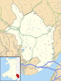
Crick, Monmouthshire

Last updated

Crick
Monmouthshire UK location map.svg
Red pog.svg
Crick
Location within Monmouthshire
OS grid reference ST483904
Principal area
Preserved county
Country Wales
Sovereign state United Kingdom
Post town CALDICOT
Postcode district NP26
Dialling code 01291
Police Gwent
Fire South Wales
Ambulance Welsh
UK Parliament
List of places
UK
Wales
Monmouthshire
51°36′36″N2°44′53″W / 51.61005°N 2.74800°W / 51.61005; -2.74800

Crick (Welsh : Crug) is a small village or hamlet in the Welsh county of Monmouthshire, United Kingdom. It is located on the A48 road 1 mile north of the town of Caldicot and 1 mile east of Caerwent.

Contents

History and amenities

There is a Bronze Age round barrow just west of the village, measuring 31.7m in diameter and the only known bell barrow in Wales. It was excavated in 1940, and found to contain two cremations dating from around 1750-1450 BC. It also contained boulders showing cup marks, which it has been suggested show astronomically significant alignments. [1]

The site of Crick was an important junction on the Roman road sometimes known as the Via Julia which ran from Bath ( Aquae Sulis ) across the Severn estuary to Sudbrook and on to Caerwent ( Venta Silurum ) and Caerleon ( Isca Augusta ), now in Wales. At Crick the route met the roads to Gloucester ( Glevum ) and Monmouth ( Blestium ). [2]

There is also evidence of an early Norman motte and bailey castle at Ballan Moor near Crick, probably built by the Ballon family in the late 11th or early 12th century.

In July 1645, during the English Civil War, a mediaeval hall at Crick was the site of a key meeting between King Charles, who had been recently defeated at Langport in Somerset, and his nephew and ally Prince Rupert of the Rhine. [3] [4]

David Broome, the former international equestrian show jumper is from the area and runs the David Broome Event Centre at Mount Ballan. [5]

See also

Related Research Articles

<span class="mw-page-title-main">Abergavenny</span> Market town in Monmouthshire, Wales

Abergavenny is a market town and community in Monmouthshire, Wales. Abergavenny is promoted as a Gateway to Wales; it is approximately 6 miles (10 km) from the border with England and is located where the A40 trunk road and the A465 Heads of the Valleys road meet.

<span class="mw-page-title-main">Chepstow</span> Human settlement in Wales

Chepstow is a town and community in Monmouthshire, Wales, adjoining the border with Gloucestershire, England. It is located on the tidal River Wye, about 2 miles (3 km) above its confluence with the River Severn, and adjoining the western end of the Severn Bridge. It is the easternmost settlement in Wales, situated 16 miles (26 km) east of Newport, 28 miles (45 km) east-northeast of Cardiff, 18 miles (29 km) northwest of Bristol and 110 miles (180 km) west of London.

<span class="mw-page-title-main">Trellech</span> Human settlement in Wales

Trellech is a village and parish in Monmouthshire, south-east Wales. Located 5 miles (8 km) south of Monmouth and 4 miles (6.4 km) north-north-west of Tintern, Trellech lies on a plateau above the Wye Valley on the southern fringes of 320 acres (130 ha) of woodland in an Area of Outstanding Natural Beauty. Three Bronze Age standing stones are situated in the village, known as Harold's Stones, which overlook the historic church of St Nicholas, a Grade I listed building.

<span class="mw-page-title-main">Caldicot, Monmouthshire</span> Town in Wales

Caldicot is a market town and community in Monmouthshire, Wales. The town is located between Chepstow and the city of Newport. The site adjoins the Caldicot Levels, on the north side of the Severn Estuary. The population of the built-up area was around 11,000. It has a large school, Caldicot School, and is known for its medieval castle. The built-up area includes Portskewett. Caldicot had a population of 9,604 in 2011.

<span class="mw-page-title-main">Caerwent</span> Human settlement in Monmouthshire, Wales

Caerwent is a village and community in Monmouthshire, Wales. It is located about five miles west of Chepstow and 11 miles east of Newport. It was founded by the Romans as the market town of Venta Silurum, an important settlement of the Brythonic Silures tribe. The modern village is built around the Roman ruins, which are some of the best-preserved in Europe. It remained prominent through the Roman era and Early Middle Ages as the site of a road crossing between several important civic centres. The community includes Llanvair Discoed. The village itself had a population of about 1,200.

<span class="mw-page-title-main">St. Brides Netherwent</span>

St. Brides Netherwent is a parish and largely deserted village in Monmouthshire, south-east Wales. It is centred 2 miles north of Magor, and 3 miles west of Caerwent. The A48 Newport to Chepstow road passes close by to the north.

<span class="mw-page-title-main">Llanvaches</span> Human settlement in Wales

Llanvaches or Llanfaches is a village and community parish within the boundaries of the city of Newport, Wales. It lies to the east of the urban area, in the historic county of Monmouthshire and the preserved county of Gwent. The population rose to 402 by the 2011 census.

<span class="mw-page-title-main">Caerwent Training Area</span>

Caerwent Training Area is a British military installation at Caerwent, Monmouthshire, Wales. The large military site is situated north of the A48 road about 5 mi (8.0 km) west of Chepstow and 12 miles (19 km) east of Newport.

<span class="mw-page-title-main">Llanvair Discoed</span> Human settlement in Wales

Llanvair Discoed is a small village in Monmouthshire, south-east Wales, 6 miles west of Chepstow and 10 miles east of Newport.

<span class="mw-page-title-main">Venta Silurum</span> Historic site in Wales, UK

Venta Silurum was a town in Roman Britain (Britannia). Today it consists of remains in the village of Caerwent in Monmouthshire, south east Wales.

<span class="mw-page-title-main">Kingdom of Gwent</span> Kingdom in South Wales

Gwent was a medieval Welsh kingdom, lying between the Rivers Wye and Usk. It existed from the end of Roman rule in Britain in about the 5th century until the Norman invasion of Wales in the 11th century. Along with its neighbour Glywyssing, it seems to have had a great deal of cultural continuity with the earlier Silures, keeping their own courts and diocese separate from the rest of Wales until their conquest by Gruffydd ap Llywelyn. Although it recovered its independence after his death in 1063, Gwent was the first of the Welsh kingdoms to be overrun following the Norman conquest.

<span class="mw-page-title-main">David Broome</span> Welsh equestrian

David McPherson Broome is a retired Welsh show jumping champion. He competed in the 1960, 1964, 1968, 1972 and 1988 Olympics and won individual bronze medals in 1960 on Sunsalve and in 1968 on his best-known horse Mr Softee. In 1960, he was also voted BBC Sports Personality of the Year, and at the 1972 Games served as the Olympic flag bearer for Great Britain.

<span class="mw-page-title-main">Portskewett</span> Village and community in Monmouthshire, Wales

Portskewett is a village and community (parish) in Monmouthshire, south east Wales. It is located four miles south west of Chepstow and one mile east of Caldicot, in an archaeologically sensitive part of the Caldicot Levels on the Welsh shore of the Severn Estuary. The Second Severn Crossing passes overhead carrying the M4 motorway. The community includes Sudbrook, Crick and Leechpool.

<span class="mw-page-title-main">Sudbrook, Monmouthshire</span> Human settlement in Wales

Sudbrook is a village in Monmouthshire, south east Wales. It is located 4 miles south west of Chepstow and 1 mile east of Caldicot. It lies close to the Second Severn Crossing on the Severn Estuary, and adjoins the village of Portskewett. It was largely built in the late 19th century for workers on the Severn railway tunnel. At that time it was also known as Southbrook.

Sir Trevor Williams, 1st Baronet of Llangibby, Monmouthshire, was a Welsh gentry landowner and politician who sat in the House of Commons at various times between 1660 and 1692. He played a significant part in events during and after the English Civil War in South Wales, siding first with King Charles, then with the Parliamentarians, before rejoining the Royalists in 1648.

<span class="mw-page-title-main">England–Wales border</span> National boundary between England and Wales

The England–Wales border, sometimes referred to as the Wales–England border or the Anglo-Welsh border, runs for 160 miles (260 km) from the Dee estuary, in the north, to the Severn estuary in the south, separating England and Wales.

<span class="mw-page-title-main">Caerleon Roman Fortress and Baths</span> Archaeological museum in Newport, Wales

Caerleon Roman Fortress and Baths encompass the archaeological ruins and sites of the Legionary Fortress of Isca Augusta spread across the town of Caerleon, near the city of Newport, South Wales. Notable for being one of only three permanent legionary fortresses from Roman Britain, Caerleon has provided a unique opportunity to study the archaeology of a Roman Legionary fortress, less affected by the medieval and subsequent urban activity of most such fortresses. Having attracted the attention of eminent archaeologists throughout the 20th century it now has four major public archaeological venues, including the museum run by Cadw, called 'Caerleon Roman Fortress and Baths', featuring the excavated fortress bath-house. Also open to the public is the most complete excavated amphitheatre in Britain, a series of barracks and the National Roman Legion Museum. The fortress and its surrounding civil settlement have been the subject of continuing major archaeological investigations into the 21st century.

<span class="mw-page-title-main">Manor Farmhouse, Crick</span> Historic building in Crick, Monmouthshire, Wales

Manor Farmhouse, or Crick Manor, Crick, Monmouthshire is a late medieval manor house dating from the 15th century. The buildings comprise a chapel, of 13th century origins, now a separate house, the medieval, stone hall, and a 16th-century wing. The buildings were originally constructed for the Denefords, and extended by their descendants, the Moores. In the 17th century, Nicholas Moore, High Sheriff of Monmouthshire entertained Charles I at the manor. The grouping has been "badly compromised" in later centuries. The house, privately owned and accommodating an archery centre, is Grade II* listed.

References

  1. Martin Powell, Astronomical alignments at the Crick barrow in Gwent, South Wales
  2. Roman roads in south east Wales
  3. "English Civil War Timeline". Archived from the original on 23 May 2006. Retrieved 6 November 2008.
  4. Jeremy Knight, Civil War and Restoration in Monmouthshire, 2005, ISBN   1-904396-41-0
  5. David Broome Event Centre