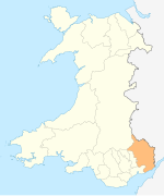
Llanwenarth is a small village and parish in the Usk Valley of Monmouthshire, south-east Wales, United Kingdom. It is in the community of Llanfoist Fawr and covered by the electoral ward of Llanwenarth Ultra.
Llanwenarth is a small village and parish in the Usk Valley of Monmouthshire, south-east Wales, United Kingdom. It is in the community of Llanfoist Fawr and covered by the electoral ward of Llanwenarth Ultra.
Llanwenarth is located two miles (3 km) west of the market town of Abergavenny, close to the banks of the River Usk. [1]
St Peter's Church is the parish church: an ogival-headed priest's doorway in the chancel, and two windows with reticulated tracery are assigned to the fourteenth century, and a lancet in the west wall of the nave seems to be from the thirteenth, [2] where a square tower with battlemented top was added later. The village once had a Victorian schoolhouse (now demolished). The village, which has the full name of Llanwenarth Citra, sits in flattish grassy pastures [3] between the Blorenge mountain and the Sugar Loaf Mountain, Wales. Some of these meadows have been designated a Site of Special Scientific Interest(SSSI). Llanwenarth House was built in the 16th century and is operated as a hotel, located to the west of nearby Govilon.
The busy A40 Abergavenny to Brecon road passes along the valley side above the flood plain of the River Usk, and Nevill Hall Hospital is situated close by on the outskirts of Abergavenny town.
The annual Abergavenny and Border Counties Show, similar to Monmouth Show, used to be held on the fields close to the church until the 1990s.
An old cable ferry (similar to Hampton Loade Ferry on the River Severn) used to be used in Victorian times to cross the River Usk from a field on the Abergavenny/Llanwenarth side to the Govilon side of the river, where the bank was referred to as 'Llanwenarth Ultra.'
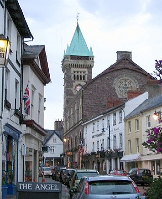
Abergavenny is a market town and community in Monmouthshire, Wales. Abergavenny is promoted as a Gateway to Wales; it is approximately 6 miles (10 km) from the border with England and is located where the A40 trunk road and the recently upgraded A465 Heads of the Valleys road meet.

The River Usk rises on the northern slopes of the Black Mountain, Wales, in the westernmost part of the Brecon Beacons National Park. Initially forming the boundary between Carmarthenshire and Powys, it flows north into Usk Reservoir, then east by Sennybridge to Brecon before turning southeast to flow by Talybont-on-Usk, Crickhowell and Abergavenny, after which it takes a more southerly course.

Crickhowell is a town and community in southeastern Powys, Wales, near Abergavenny, and is in the historic county of Brecknockshire.

Llanfoist is a village near Abergavenny, in Monmouthshire, Wales, in the community of Llanfoist Fawr. Llanfoist derives from Ffwyst, an early Christian Welsh saint, although the anglicised version of the church patron is Saint Faith. The population was 1,228 in 2011.
Llanelly is the name of a parish and coterminous community in the principal area of Monmouthshire, within the historic boundaries of Brecknockshire, south-east Wales. It roughly covers the area of the Clydach Gorge. The population of the parish and ward at the 2011 census was 3,899.

Blorenge, also called The Blorenge, is a prominent hill overlooking the valley of the River Usk near Abergavenny, Monmouthshire, southeast Wales. It is situated in the southeastern corner of the Brecon Beacons National Park. The summit plateau reaches a height of 561 metres (1,841 ft).

Kemeys Commander is a village in Monmouthshire, in South East Wales.
Llanbadoc is a village and community in the county of Monmouthshire and the preserved county of Gwent in Wales. The population of the village at the 2011 census was 806.

Gilwern is a village within the Brecon Beacons National Park in Monmouthshire, Wales. Historically in Brecknockshire, it extends to either side of the River Clydach on the south side of the Usk valley. Its position beside the Monmouthshire and Brecon Canal led to it being an important industrial centre at one time.

Govilon is a small Welsh village located between Llanfoist and Gilwern near Abergavenny in north Monmouthshire. It is part of the community of Llanfoist Fawr. The population was 1,447 in 2011.

Llanvihangel Crucorney is a small village in the community (parish) of Crucorney, Monmouthshire, Wales. It is located 5 miles (8.0 km) north of Abergavenny and 18 miles (29 km) southwest of Hereford, England on the A465 road.

Pandy is a hamlet in Monmouthshire, south east Wales, United Kingdom.

Gobannium was a Roman fort and civil settlement or Castra established by the Roman legions invading what was to become Roman Wales and lies today under the market town of Abergavenny, Monmouthshire in south east Wales.

The River Gavenny or sometimes the Gavenny River is a short river in Monmouthshire in south Wales. It rises 1 mile (1.6 km) southwest of the village of Llanvihangel Crucorney from springs near Penyclawdd Court, supplemented by springs in Blaen-Gavenny Wood and tributary streams there and within the Woodland Trust-owned Great Triley Wood. It flows south for about 4 miles (6.4 km) to its confluence with the River Usk towards the eastern end of Castle Meadows at Abergavenny. The town derives its English-language name from the Gavenny's confluence with the River Usk. Of the buildings on the banks of the river, the Gothic Decorated style church of St Teilo at Llantilio Pertholey is especially notable. Parts of the church date from the thirteenth century with multiple additions since. Blaengavenny Farm, the name of which signifies the 'head of the Gavenny', is a sixteenth-century farmhouse near the river's source.

Tor y Foel is a hill in the Brecon Beacons National Park in the county of Powys in Wales. It is located on the eastern flank of Talybont Reservoir, and the summit at 551m is marked by a small cairn. It gives excellent panoramic views over the valley of the River Usk, across to the Black Mountains and west to the Brecon Beacons.
Mynydd Llangynidr is a mountain in the Brecon Beacons National Park largely in the county of Powys, south Wales. Its southern slopes extend into the northernmost parts of the county borough of Blaenau Gwent. It is named from the village of Llangynidr which sits in the valley of the River Usk to the north of it. It is essentially an undulating plateau rising in the west to a height of 557m at Garn Fawr at OS grid ref SO 123151. A secondary high point is achieved at a point marked by a trig point at SO 147159. To the north the hill overlooks the valleys of Dyffryn Crawnon and Cwm Claisfer, themselves tributary valleys of the Usk. The shallow upper valley of the Ebbw River reaches into the plateau in the southeast whilst the upper reaches of the Sirhowy Valley and its tributary the Nant Trefil define its western margins. A further tributary, the Nant Milgatw, reaches in from the south whilst the sharp edge of Rassau Industrial Estate also defines a part of its southern margin. Passing east across the B4560, the hill merges with Mynydd Llangatwg which has a similar character.

Allt yr Esgair is a hill in the Brecon Beacons National Park in Powys, Wales. It is commonly referred to locally as simply 'The Allt'. The Welsh name signifies 'wooded slope of the ridge'. It takes the form of a northwest-southeast aligned ridge which rises to a height of 393m and which overlooks the valley of the River Usk to the west and south. To the northeast are panoramic views across Llangorse Lake to the Black Mountains There is a viewfinder on the summit erected as a monument to Eirene Lloyd White, Baroness White of Rhymney. It is a Marilyn with a prominence of 199 metres.

Llanwenarth House is a small country house, formerly a hotel, located off the B4246 road, west of Govilon and Llanfoist, just south of Abergavenny in the Usk valley of Monmouthshire, Wales. It was built in the late 16th century, although the drawing room and some of the furnishings are from the Georgian period.

Llanwenarth Baptist Chapel, Govilon, Monmouthshire is the oldest Baptist chapel in Wales. Founded in 1652, the present building was constructed in 1695, and was remodelled in the 18th, 19th and 21st centuries. The chapel is a Grade II* listed building and remains an active Baptist chapel.
Llanwenarth Ultra is an electoral ward near Abergavenny, Monmouthshire. The ward elects councillors to Llanfoist Fawr Community Council and Monmouthshire County Council.
51°49′N3°03′W / 51.817°N 3.050°W
| | This article relating to a location in Monmouthshire is a stub. You can help Wikipedia by expanding it. |