
The Feather River is the principal tributary of the Sacramento River, in the Sacramento Valley of Northern California. The river's main stem is about 73 miles (117 km) long. Its length to its most distant headwater tributary is just over 210 miles (340 km). The main stem Feather River begins in Lake Oroville, where its four long tributary forks join—the South Fork, Middle Fork, North Fork, and West Branch Feather Rivers. These and other tributaries drain part of the northern Sierra Nevada, and the extreme southern Cascades, as well as a small portion of the Sacramento Valley. The total drainage basin is about 6,200 square miles (16,000 km2), with approximately 3,604 square miles (9,330 km2) above Lake Oroville.

The Clavey River is a tributary of the Tuolumne River in the Sierra Nevada, located in the Stanislaus National Forest and Tuolumne County, California. The river is 31.3 miles (50.4 km) long, and is one of the few undammed rivers on the western slope of the Sierra. Via the Tuolumne River, the Clavey is part of the San Joaquin River watershed.
Feather Falls is a rural unincorporated community in Butte County, California north and east of Lake Oroville. It lies at an elevation of 2982 feet. It is home to Feather Falls Elementary School, a K-8 facility. It takes its name from the nearby 410-foot Feather Falls
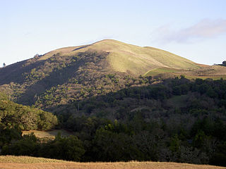
Bald Mountain is a name given to over fifty summits in California.
Sicard Flat is an unincorporated community in Yuba County, California, USA. It is located 3 miles (4.8 km) west-northwest of Smartville, at an elevation of 348 feet. The name honors Theodore Sicard, miner and merchant, who settled here in 1848.

Little Blitzen River is a 12.5-mile (20.1 km) tributary of the Donner und Blitzen River in the U.S. state of Oregon. Little Blitzen River rises on the west flank of Steens Mountain about 20 miles (32 km) southeast of Frenchglen and about 70 miles (110 km) south of Burns in Harney County. Flowing west in a steep-walled canyon, it joins the South Fork Donner und Blitzen River at 42.6737752°N 118.7935277°W to form the Donner und Blitzen main stem, which continues north about another 40 miles (64 km) to its mouth at 43.291542°N 118.8199273°W in Malheur Lake. The Donner und Blitzen River was named by soldiers of German origin and translates as "thunder and lightning". Little Blitzen River brings to mind one of Santa Claus's reindeer.

Camp Richardson is an unincorporated community at Lake Tahoe, in El Dorado County, California. It lies at an elevation of 6250 feet in the Sierra Nevada.

Lake Valley is an unincorporated community in El Dorado County, California. It extends for 8 miles (13 km) along the Upper Truckee River from Lake Tahoe to Meyers, at an elevation of 6207 feet.
Outingdale is an unincorporated community in El Dorado County, California. It is located on the Middle Fork of the Cosumnes River 4 miles (6.4 km) north of Aukum, at an elevation of 1624 feet.

The South Fork Kings River is a 44.1-mile (71.0 km) tributary of the Kings River in the Sierra Nevada of Fresno County, California. The river forms part of Kings Canyon, the namesake of Kings Canyon National Park and one of the deepest canyons in North America with a maximum relief of 8,200 feet (2,500 m) from rim to river.
The Little Kern River is a 24.4-mile-long (39.3 km) major tributary of the upper Kern River in the Sequoia National Forest, in the southern Sierra Nevada, California. It is one of three streams, along with Volcano Creek and Golden Trout Creek, that harbor beautiful golden trout.
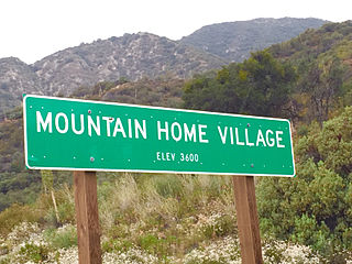
Mountain Home Village is an unincorporated community in San Bernardino County, California, United States with a population of 170 full-time residents as of 2010. Mountain Home Village is located along California State Route 38 5.2 miles (8.4 km) north-northeast of Yucaipa. It is located less than a mile east from the Thurman Flats Picnic Area, and the Loch Leven- and Mill Creek Campgrounds are located in the village. It is also where Mill Creek and Mountain Home Creek meets, while other creeks in area includes Skinner Creek, East Fork Mountain Home Creek, and Frustration Creek. The Mentone Boulders is also located nearby, which is a well-known rock-climbing area. It is located in the San Bernardino Mountains, just at the edge of the San Andreas Fault and offers some extraordinary valley views, and on clear days, also views of the City of San Bernardino. There are also numerous hiking trails located by the village. It is located within the San Bernardino National Forest and is surrounded by pine forest. Its elevation is 3600 feet.
Temescal Mountains, also known as the Sierra Temescal, are one of the northernmost mountain ranges of the Peninsular Ranges in western Riverside County, in Southern California in the United States. They extend for approximately 25 mi (40 km) southeast of the Santa Ana River east of the Elsinore Fault Zone to the Temecula Basin and form the western edge of the Perris Block.

Deep Creek is a tributary of the Mojave River, 23.4 miles (37.7 km) long, in San Bernardino County, California.

A triple divide or triple watershed is a point on the Earth's surface where three drainage basins meet. A triple divide results from the intersection of two drainage divides. Triple divides range from prominent mountain peaks to minor side peaks, down to simple slope changes on a ridge which are otherwise unremarkable. The elevation of a triple divide can be thousands of meters to barely above sea level. Triple divides are a common hydrographic feature of any terrain that has rivers, streams and/or lakes.
La Vereda del Monte was a backcountry route through remote regions of the Diablo Range, one of the California Coast Ranges. La Vereda del Monte was the upper part of La Vereda Caballo,, used by mesteñeros from the early 1840s to drive Alta California horses to Sonora for sale.
Tommie Creek is a stream in Polk County in the U.S. state of Missouri. It is a tributary of Slagle Creek.
First Creek is a stream in eastern Iron and western St Francois counties in the U.S. state of Missouri. It is a tributary of the St. Francis River. The stream headwaters are at 37°40′01″N90°39′16″W and the confluence with the St. Francis ia at 37°42′13″N90°39′07″W. The stream source area lies northwest of Middlebrook and the stream flows northeast to north paralleling Missouri Route W. Just southwest of Iron Mountain the streamcourse veers northwest and re-enters Iron County to its confluence with the St. Francis.


