| Mount Baldwin | |
|---|---|
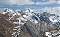
 Northeast aspect | |
| Highest point | |
| Elevation | 12,614 ft (3,845 m) [1] [2] |
| Prominence | 518 ft (158 m) [3] |
| Parent peak | Red Slate Mountain (13,163 ft) [2] |
| Isolation | 1.97 mi (3.17 km) [2] |
| Listing | Sierra Peaks Section |
| Coordinates | 37°31′55″N118°51′05″W / 37.5320615°N 118.8512690°W [4] |
| Geography | |
 Mount Baldwin Location in California  Mount Baldwin Mount Baldwin (the United States) | |
| Country | United States |
| State | California |
| County | Mono |
| Protected area | John Muir Wilderness |
| Parent range | Sierra Nevada [3] |
| Topo map | USGS Convict Lake |
| Geology | |
| Rock age | Paleozoic |
| Rock type | metamorphic rock |
| Climbing | |
| First ascent | 1928 [5] |
| Easiest route | class 2 [2] |
Mount Baldwin is a 12,614-foot-elevation (3,845-meter) mountain summit located in the Sierra Nevada mountain range in Mono County of northern California, United States. [4] It is situated in the John Muir Wilderness on land managed by Inyo National Forest. It is four miles north of Red and White Mountain, and approximately 10.5 miles (16.9 km) southeast of the community of Mammoth Lakes. The nearest higher neighbor is Red Slate Mountain, 2 miles (3.2 km) to the south-southwest. [3] Baldwin ranks as the 257th highest summit in California. [2] Topographic relief is significant as the east aspect rises 3,775 feet (1,151 meters) above McGee Canyon in 1.5 mile. The first ascent of the summit was made July 2, 1928, by Norman Clyde, who is credited with 130 first ascents, most of which were in the Sierra Nevada. [1]