
The Sierra Nevada is a mountain range in the Western United States, between the Central Valley of California and the Great Basin. The vast majority of the range lies in the state of California, although the Carson Range spur lies primarily in Nevada. The Sierra Nevada is part of the American Cordillera, an almost continuous chain of mountain ranges that forms the western "backbone" of the Americas.

Mount Whitney is the highest mountain in the contiguous United States, with an elevation of 14,505 feet (4,421 m). It is in East–Central California, in the Sierra Nevada, on the boundary between California's Inyo and Tulare counties, and 84.6 miles (136.2 km) west-northwest of North America's lowest topographic point, Badwater Basin in Death Valley National Park, at 282 ft (86 m) below sea level. The mountain's west slope is in Sequoia National Park and the summit is the southern terminus of the John Muir Trail, which runs 211.9 mi (341.0 km) from Happy Isles in Yosemite Valley. The eastern slopes are in Inyo National Forest in Inyo County. Mount Whitney is ranked 18th by topographic isolation.
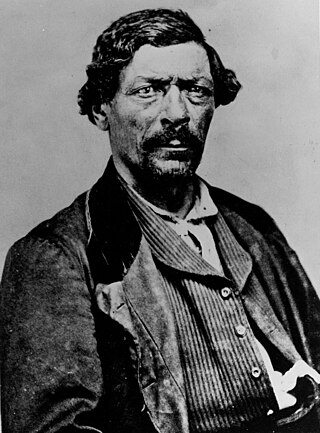
James Pierson Beckwourth was an American fur trapper, rancher, businessman, explorer, author and scout. Known as "Bloody Arm" because of his skill as a fighter, Beckwourth was of multiracial descent, being born into slavery in Frederick County, Virginia. He was eventually emancipated by his enslaver, who was also his father, and apprenticed to a blacksmith so that he could learn a trade.
Mount Gibbs is located in the Sierra Nevada of the U.S. state of California, 2.6 miles (4 km) south of Mount Dana. The mountain was named in honor of Oliver Gibbs, a professor at Harvard University and friend of Josiah Whitney. The summit marks the boundary between Yosemite National Park and the Ansel Adams Wilderness, and Mount Gibbs is the sixth-highest mountain, of Yosemite.

The Sierra Madre is a mountain range in southwestern California. It forms the southernmost part of the California Coast Ranges and lies mostly in Santa Barbara County, with a small portion extending into Ventura County. The Sierra Madre has a northwest-to-southeast orientation, bordered on the north and northeast by the Cuyama River and Cuyama Valley, and on the south and east by the drainage of the Sisquoc River.

Mount Ritter is the highest mountain in Madera County, California, in the Western United States, at an elevation of 13,149 feet (4,008 m). It is also the highest and most prominent peak of its namesake, the Ritter Range, a subrange of the Sierra Nevada in the Ansel Adams Wilderness of the Inyo and Sierra National Forests. Mount Ritter is the 15th highest mountain peak in California with at least 500 meters of topographic prominence.
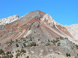
Red Slate Mountain is a summit in the Sierra Nevada. It lies along the Sierra Crest that divides Fresno County from Mono County, California.

Mount Humphreys is a mountain peak in the Sierra Nevada on the Fresno-Inyo county line in the U.S. state of California. It is the 13th highest peak in California, and the highest peak in the Bishop area. The mountain was named by the California Geological Survey of 1873 for Andrew A. Humphreys, the chief engineer of the United States Army at the time.

Mount Darwin is a flat-topped mountain in the Sierra Nevada, on the border of between Fresno and Inyo counties in Kings Canyon National Park and the John Muir Wilderness of California.

The North American Cordillera, sometimes also called the Western Cordillera of North America, the Western Cordillera, or the Pacific Cordillera, is the North American portion of the American Cordillera, the mountain chain system along the Pacific coast of the Americas. The North American Cordillera covers an extensive area of mountain ranges, intermontane basins, and plateaus in Western and Northwestern Canada, Western United States, and Mexico, including much of the territory west of the Great Plains.

Mount Williamson, at an elevation of 14,379 feet (4,383 m), is the second-highest mountain in both the Sierra Nevada range and the state of California, and the sixth-highest peak in the contiguous United States.

North Palisade is the third-highest mountain in the Sierra Nevada range of California, and one of the state's small number of peaks over 14,000 feet, known as fourteeners. It is the highest peak of the Palisades group of peaks in the central part of the Sierra range. It sports a small glacier and several highly prized rock climbing routes on its northeast side.

Mount Kaweah is a mountain in California's Sequoia National Park and forms part of the Kaweah Peaks Ridge, a spur of the Great Western Divide which extends south from Triple Divide Peak. It has a summit elevation of 13,807 ft (4,208 m), the highest along the Kaweah Peaks Ridge.

Mount Langley is a mountain located on the crest of the Sierra Nevada, on the boundary between Inyo and Tulare counties in eastern California, in the United States. To the east is the Owens Valley, and to the west is the Kern River Valley. It is the ninth-highest peak in the state and the seventh-highest in the Sierra. Mount Whitney, the highest peak in the contiguous United States, lies 4.8 miles (7.7 km) to the northwest. Mount Langley also has the distinction of being the southernmost fourteener in the United States.

Split Mountain is a fourteener in the Sierra Nevada of the U.S. state of California, near the southeast end of the Palisades group of peaks. It is the only fourteener in the watershed of the South Fork Kings River, and it rises to 14,064 feet (4,287 m), making it the eighth-highest peak in the state.
Middle Palisade is a 14,018-foot (4,273-meter) peak in the central Sierra Nevada mountain range in the U.S. state of California. It is a fourteener, and lies on the Sierra Crest as part of the Palisades group, a group of prominent Sierra Nevada mountain summits that includes multiple other fourteeners, approximately 12 miles (19 km) southwest of the town of Big Pine. Middle Palisade is the twelfth highest peak in California.

Olancha Peak is a mountain in the Sierra Nevada of California. It rises to an elevation of 12,132 feet (3,698 m) on the Tulare-Inyo county line in the South Sierra Wilderness. It takes its name from the nearby town of Olancha.

Sierra Azul Open Space Preserve is managed by the Midpeninsula Regional Open Space District in Santa Clara County, California. It is approximately 19,300 acres (7,800 ha) in area. The preserve is named for the Sierra Azul or "Blue Mountains", the name the colonizing Spanish used for the half of the Santa Cruz Mountains south of today's California Highway 17.

Mount Keith is a mountain on the crest of California's Sierra Nevada, between Mount Bradley to the north, and Junction Peak to the southwest. Its north and west facing slopes feed the Kings River watershed by way of Bubbs Creek, and its east and south slopes feed the Owens River via Shepherd Creek. By the same dividing line, Keith stands on the boundary of Kings Canyon National Park to the northwest, and the John Muir Wilderness to the southeast. It is a thirteener, a mountain which has a height over 13000 feet.
Herlihy Peak is an 11,758-foot-elevation (3,584 meter) mountain summit located in the Sierra Nevada mountain range in Mono County of northern California, United States. It is situated approximately four miles south of the community of Mammoth Lakes, in the John Muir Wilderness, on land managed by Inyo National Forest. Herlihy Peak is positioned midway between landmarks Crystal Crag and Bloody Mountain. Topographic relief is significant as the east aspect rises 2,060 feet above Valentine Lake in approximately one mile, and the west aspect rises 1,844 feet above Skelton Lake in 0.8 mile. Precipitation runoff from the peak drains to Mammoth Creek.


