The Sierra Madre is a mountain range in southwestern California. It forms the southernmost part of the California Coast Ranges and lies mostly in Santa Barbara County, with a small portion extending into Ventura County. The Sierra Madre has a northwest-to-southeast orientation, bordered on the north and northeast by the Cuyama River and Cuyama Valley, and on the south and east by the drainage of the Sisquoc River.

Mount Ritter is the highest mountain in Madera County, California, in the Western United States, at an elevation of 13,149 feet (4,008 m). It is also the highest and most prominent peak of its namesake, the Ritter Range, a subrange of the Sierra Nevada in the Ansel Adams Wilderness of the Inyo and Sierra National Forests. Mount Ritter is the 15th highest mountain peak in California with at least 500 meters of topographic prominence.
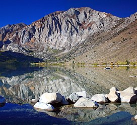
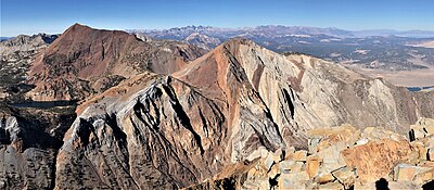
Red Slate Mountain is a summit in the Sierra Nevada. It lies along the Sierra Crest that divides Fresno County from Mono County, California.

Mount Humphreys is a mountain peak in the Sierra Nevada on the Fresno-Inyo county line in the U.S. state of California. It is the 13th highest peak in California, and the highest peak in the Bishop area. The mountain was named by the California Geological Survey of 1873 for Andrew A. Humphreys, the chief engineer of the United States Army at the time.

Castle Peak is a mountain in California's Sierra Nevada near I-80, Donner Pass, and the Nevada border. It is in the Tahoe National Forest not far off the Pacific Crest Trail, and adjacent to Castle Pass. It was originally named Mount Stanford by the Whitney Survey of 1860–1874.
Pyramid Peak is a mountain in the California's Sierra Nevada in the Crystal Range to the west of Lake Tahoe. It is the highest point in the Desolation Wilderness. With an elevation gain of almost 4,100 feet (1,250 m), the Rocky Canyon route is the mountain's most popular approach although it is very arduous. To the east, at the base of the peak, lies Pyramid Lake.

Mount Williamson, at an elevation of 14,379 feet (4,383 m), is the second-highest mountain in both the Sierra Nevada range and the state of California, and the sixth-highest peak in the contiguous United States.

North Palisade is the third-highest mountain in the Sierra Nevada range of California, and one of the state's small number of peaks over 14,000 feet, known as fourteeners. It is the highest peak of the Palisades group of peaks in the central part of the Sierra range. It sports a small glacier and several highly prized rock climbing routes on its northeast side.

Mount Kaweah is a mountain in California's Sequoia National Park and forms part of the Kaweah Peaks Ridge, a spur of the Great Western Divide which extends south from Triple Divide Peak. It has a summit elevation of 13,807 ft (4,208 m), the highest along the Kaweah Peaks Ridge.

Split Mountain is a fourteener in the Sierra Nevada of the U.S. state of California, near the southeast end of the Palisades group of peaks. It is the only fourteener in the watershed of the South Fork Kings River, and it rises to 14,064 feet (4,287 m), making it the eighth-highest peak in the state.

Mount Tallac is a mountain peak southwest of Lake Tahoe, in El Dorado County, California. The peak lies within the Desolation Wilderness in the Eldorado National Forest. It is quite visible from State Routes 89 and 28, and U.S. Route 50. A "cross of snow" is clearly visible on the mountain's face during the winter, spring, and early summer months.

Table Mountain is located near the northern end of the Great Western Divide, a sub-range of the Sierra Nevada in California. The summit marks a point on the boundary between Sequoia and Kings Canyon national parks and is 0.6 miles (1 km) south of Thunder Mountain and 1.3 miles (2.1 km) northeast of Midway Mountain.

Freel Peak is a mountain located in the Carson Range, a spur of the Sierra Nevada, near Lake Tahoe in California.

Mount Lola is a mountain in the Sierra Nevada of California. Its summit, located north of Donner Pass and Interstate 80, is the highest point in Nevada County. It is also the highest point in the Sierra Nevada north of Interstate 80. A subsidiary peak 1.2 miles (1.9 km) north of the main summit is highest point in Sierra County at 8,848 feet (2,697 m) NAVD 88.

Olancha Peak is a mountain in the Sierra Nevada of California. It rises to an elevation of 12,132 feet (3,698 m) on the Tulare-Inyo county line in the South Sierra Wilderness. It takes its name from the nearby town of Olancha.

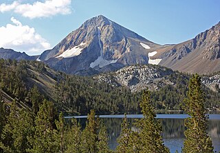
Mount Morgan is a mountain located in northwestern Inyo County, California, in the John Muir Wilderness of the Inyo National Forest.

Mount Keith is a mountain on the crest of California's Sierra Nevada, between Mount Bradley to the north, and Junction Peak to the southwest. Its north and west facing slopes feed the Kings River watershed by way of Bubbs Creek, and its east and south slopes feed the Owens River via Shepherd Creek. By the same dividing line, Keith stands on the boundary of Kings Canyon National Park to the northwest, and the John Muir Wilderness to the southeast. It is a thirteener, a mountain which has a height over 13000 feet.

Red and White Mountain is a remote 12,816-foot-elevation mountain summit located on the crest of the Sierra Nevada mountain range in northern California, United States. It is situated in the John Muir Wilderness on the shared boundary of Sierra National Forest with Inyo National Forest, and along the common border of Fresno County with Mono County. It is eight miles northeast of Lake Thomas A Edison, and approximately 13 miles (21 km) southeast of the community of Mammoth Lakes. The nearest higher neighbor is Red Slate Mountain, 2 miles (3.2 km) to the north-northwest.

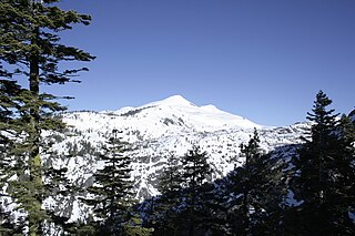
Mount Baldwin is a 12,614-foot-elevation (3,845-meter) mountain summit located in the Sierra Nevada mountain range in Mono County of northern California, United States. It is situated in the John Muir Wilderness on land managed by Inyo National Forest. It is four miles north of Red and White Mountain, and approximately 10.5 miles (16.9 km) southeast of the community of Mammoth Lakes. The nearest higher neighbor is Red Slate Mountain, 2 miles (3.2 km) to the south-southwest. Baldwin ranks as the 257th highest summit in California. Topographic relief is significant as the east aspect rises 3,775 feet above McGee Canyon in 1.5 mile. The first ascent of the summit was made July 2, 1928, by Norman Clyde, who is credited with 130 first ascents, most of which were in the Sierra Nevada.