Loch Libo

Last updated

Loch Libo
Caldwell - later Uplawmoor, station site geograph-3098674-by-Ben-Brooksbank.jpg
Loch Libo and the railway to Glasgow
East Renfrewshire UK relief location map.jpg
Red pog.svg
Loch Libo
Location Uplawmoor, East Renfrewshire, Scotland
Coordinates Coordinates: 55°46′8.3″N4°29′45.9″W / 55.768972°N 4.496083°W / 55.768972; -4.496083
Lake type Old freshwater loch
Primary inflows Thorter Burn, rainfall and natural drainage
Primary outflows Lugton Water
Basin  countriesScotland
Surface area 24 acres (9.7 ha)
Average depthShallow
Surface elevation395 ft (120 m)
Islands None
Settlements Neilston

Loch Libo is a freshwater loch in East Renfrewshire, Parish of Neilston, Scotland. The Lugton Water has its source from the southern end of loch, running 14 miles before reaching its confluence with the River Garnock near Kilwinning. The village of Uplawmoor and the hamlet of Shillford lie nearby. 3 mi (4.8 km) away to the northeast is the town of Neilston.

Contents

History

The name is of great antiquity and 'Libo' may be pre-Gaelic in origin. [1] The loch lies in a glen, with Caldwell Law to the north and Uplawmoor Wood to the south. [2] In the 14th century was referred to as 'Loch le Bog Syde' in a charter, meaning the 'Bogside Loch'. [3] The loch is now owned by the Scottish Wildlife Trust (SWT) and is managed as a nature reserve. [4]

Usage

Transport

Pedestrian crossing over the railway Pedestrian Railway crossing - geograph.org.uk - 1541511.jpg
Pedestrian crossing over the railway

.

The old turnpike, now the A736 Lochlibo Road (locally known as the 'Low Road'), ran for about a mile along the southern margin of the loch, later joined by the Glasgow, Barrhead and Kilmarnock Joint Railway that stands even closer to the loch's waters. [2] Caldwell railway station, later renamed Uplawmoor was situated close by and was convenient for visitors, such as curlers, who used the loch. The station closed in 1966, the railway remaining open, although the track has been singled; pedestrians cross the line to access the loch at a dedicated railway crossing with trains passing every fifteen minutes on weekdays (datum 2012).

Angling

Loch Libo's waters are recorded to hold tench, eels, perch, pike, carp, and roach (braise in Scots); it is however the fishing preserve of the Scottish Carp Group members as is advertised by signs erected at the loch shore. [5] [6] The 1895 OS map shows a boat house on the northern side near where a burn feeds into the loch. [7]

Curling

Curling matches began at Loch Libo in 1885 when a Curling-stone house was built. The club cancelled all matches ‘during the current emergency’ from 1915 to 1919 where the minutes also record that there were insufficient members to form a quorum at the AGM during these war years. In 1919 The club moved to Kirkton Dam and arrangements were put in hand to relocate the Curling-stone house from Loch Libo. The loch and its back drop The Neilston Pad form the Club Badge worn on Neilston CC sports wear, in the club colours of dark blue, light blue and white. [8]

The Neilston Curling Club members enjoyed concessions granted by the Glasgow, Barrhead and Kilmarnock Joint Railway Company for members and their curling stones to travel between Neilston and Caldwell stations and return for the cost of the single journey. A key for the clubhouse was also kept at the then Caldwell station. [8]

Cartographic evidence

The loch is roughly oval in shape, generally shallow, but of considerable depth in the centre. [3] Timothy Pont's map of circa 1601 records 'Loch Libo' with the present spelling, as does the 1654 map of Blaeu. John Ainslie's map renders the name as 'Loch Lebe'. The OS maps show a boat house until 1969. [9]

Scotland relief location map.jpg
Red pog.svg
Loch Libo
Location of Loch Libo, East Renfrewshire

Hydrology

The Lugton Water has its origins at the south-west end of the loch and the Thorter Burn was diverted to run into the loch following the construction of the Glasgow, Barrhead and Kilmarnock Joint Railway. [2] The Caldwell Law Burn runs into the loch on the northern side. A burn runs into the loch from Shillford and this is in addition to rainfall and drainage.

Coal mining

A coal seam dips down under the southern margin of the loch and a mine was dug in the 1780s. In 1793 the waters of the loch burst into the workings and at least six miners were drowned, their bodies never being recovered. A servant collecting coal was also drowned, having wandered into the pit out of curiosity. [10] Several attempts were made to drain and re-open the mine, to no avail, [5] however it was reopened around 1830 as the Loch Coal Co. with much deeper shafts and two seams being exploited, one Ell Coal and the other Craw Coal; both seams were about four feet thick. These workings were worked out many years ago. [3]

It was reported in The Scotsman , on 23 September 1843 that the original pit had been sealed and the water pumped out, exposing a skeleton of what may have been a young man, along with a pair of shoes and some buttons. The skeleton was subsequently buried at the Neilston Church cemetery. [11]

Sand quarry

The 1895 and later map shows a large sand quarry off the lane leading to Westhead of Side Farm. [7]

Natural history

Great tussock sedge at the eastern end of the loch. View of Loch Libo 's Greater Tussock Sedges.JPG
Great tussock sedge at the eastern end of the loch.

The loch and part of Caldwell-Lawside Wood have been a Site of Scientific Interest (SSSI) since 1972, covering 17.82 ha as designated by Scottish Natural Heritage (SNH) and a Scottish Wildlife Trust (SWT) wildlife site. The loch is owned by the SWT. [12]

Loch Libo is the best example of a eutrophic in East Renfrewshire with aquatic and emergent vegetation. Significant plants include the Nationally Scarce cowbane Cicuta virosa and the locally uncommon greater tussock sedge Carex paniculata and lesser pond sedge Carex acutiformis . The nationally uncommon species lesser tussock sedge Carex diandra , water sedge Carex aquatilis , slender tufted sedge Carex acuta and water parsnip Berula erecta are also present. [12]

Birds recorded at the site include: jack snipe, common snipe, grey heron, whooper swan, mute swan, teal, wigeon, goldeneye, tufted duck, mallard, coot, moorhen, buzzard, wren, coal tit, great tit, blue tit, long-tailed tit, treecreeper, great spotted woodpecker, song thrush, blackbird, robin, dunnock, chaffinch, jackdaw, carrion crow, sparrowhawk, water rail, redshank, pheasant, owls, grasshopper warbler and reed bunting. Other animals are bats, deer, mice, otters, common frog, common toad, smooth and palmate newts and water vole. [3]

Micro-history

A geocache is located in the Caldwell-Lawside Wood.

By 1895 'targets' are marked below the Caldwell-Lawside Woods at the western end of the loch. [13]

Related Research Articles

Uplawmoor Human settlement in Scotland

Uplawmoor is a village in East Renfrewshire, Scotland. Its population was 700 as of 2016.

Neilston Village in East Renfrewshire, Scotland

Neilston is a village and parish in East Renfrewshire in the west central Lowlands of Scotland. It is in the Levern Valley, two miles southwest of Barrhead, 3+34 miles south of Paisley, and 5+34 miles south-southwest of Renfrew, at the southwestern fringe of the Greater Glasgow conurbation. Neilston is a dormitory village with a resident population of just over 5,000 people.

Glasgow South Western Line Railway line in the UK

The Glasgow South Western Line is a mainline railway in Scotland that runs from Glasgow to Kilmarnock, and then either Carlisle via Dumfries, or Stranraer via Ayr, with a branch to East Kilbride.

Barrhead railway station Railway station of Barrhead, Greater Glasgow, Scotland

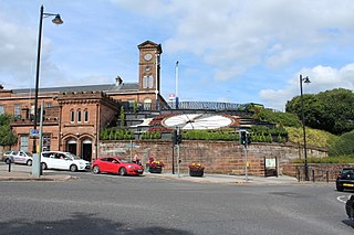
Barrhead railway station is a railway station in the town of Barrhead, East Renfrewshire, Greater Glasgow, Scotland. The station is managed by ScotRail and is on the Glasgow South Western Line, 7+12 miles (12.1 km) southwest of Glasgow Central.

Kilmaurs railway station Railway station in East Ayrshire, Scotland

Kilmaurs railway station is a railway station in the town of Kilmaurs, East Ayrshire, Scotland. The station is managed by ScotRail and is on the Glasgow South Western Line.

Kilmarnock railway station Railway station in East Ayrshire, Scotland

Kilmarnock railway station is a railway station in Kilmarnock, East Ayrshire, Scotland. The station is managed by ScotRail and is served by trains on the Glasgow South Western Line.

Lugton Human settlement in Scotland

Lugton is a small village or hamlet in East Ayrshire, Scotland with a population of 80 people. The A736 road runs through on its way from Glasgow, 15 miles (24.1 km) to the north, to Irvine in North Ayrshire. Uplawmoor is the first settlement on this 'Lochlibo Road' to the north and Burnhouse is to the south. The settlement lies on the Lugton Water which forms the boundary between East Ayrshire and East Renfrewshire as well as that of the parishes of Dunlop and Beith.

The Lanarkshire and Ayrshire Railway (L&AR) was an independent railway company built to provide the Caledonian Railway with a shorter route for mineral traffic from the coalfields of Lanarkshire to Ardrossan Harbour, in Scotland.

The Glasgow, Barrhead and Kilmarnock Joint Railway was a railway jointly owned by the Caledonian Railway and the Glasgow and South Western Railway, completed in 1873, and giving the latter a shorter access to its Carlisle main line. A branch to Beith was also built.

Uplawmoor (GB&K) railway station

Uplawmoor railway station was a railway station near the village of Uplawmoor, East Renfrewshire, Scotland. The station was originally part of the Glasgow, Barrhead and Kilmarnock Joint Railway.

The Paisley and Barrhead District Railway was a railway in Scotland that ran between the towns of Paisley and Barrhead. It was intended to serve industrial premises and develop local passenger and goods business.

Lugton Water

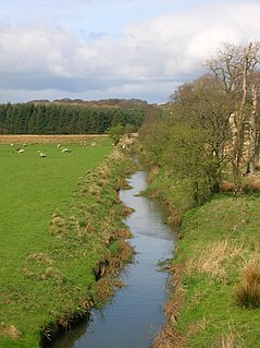
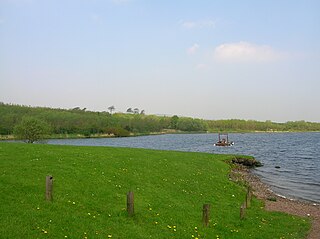
The Lugton Water, the largest tributary of the River Garnock, runs 14 miles (23 km) from Loch Libo in Uplawmoor, through Lugton and the parishes of Neilston, Beith, Dunlop, Stewarton and Kilwinning. The Lugton joins the Garnock below the tidal limit, shortly after passing through Eglinton Country Park, developed around the ancient estate of the Earl of Eglinton.

Levern Water

The Levern Water, is a small river in East Renfrewshire and Glasgow, Scotland. It rises in the Long Loch, and flows generally north and east, past the towns of Neilston and Barrhead, for a total distance of 9 miles (14 km). It empties into the White Cart River.

Caldwell, East Renfrewshire

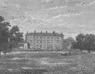
Caldwell is a mansion and old estate with the remains of a castle nearby. These lands lie close to the Lugton Water and the villages of Uplawmoor in East Renfrewshire and Lugton in East Ayrshire.

Renfrewshire South (Scottish Parliament constituency) Region or constituency of the Scottish Parliament

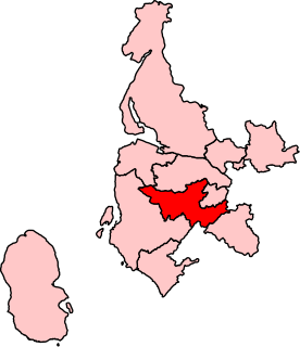
Renfrewshire South is a constituency of the Scottish Parliament covering parts of the council areas of Renfrewshire and East Renfrewshire. It elects one Member of the Scottish Parliament (MSP) by the first past the post method of election. It forms one of ten constituencies in the West Scotland electoral region, which also elects seven additional members to produce a form of proportional representation for the region as a whole.

Kilbirnie Loch Lake in the Scotland

Kilbirnie Loch, is a freshwater Loch situated in the floodplain between Kilbirnie, Glengarnock and Beith, North Ayrshire, Scotland. It runs south-west to north-east for almost 2 km (1.2 mi), is about 0.5 km (0.31 mi) wide for the most part and has an area of roughly 3 km2. It has a general depth of around 5.2 metres (17 feet) to a maximum of around 11 metres (36 feet). The loch is fed mainly by the Maich Water, which rises in the Kilbirnie Hills near Misty Law, and is drained by the Dubbs Water that runs past the Barr Loch into Castle Semple Loch, followed by the Black Cart, the White Cart at Renfrew and finally the River Clyde. The boundary between East Renfrewshire and North Ayrshire, in the vicinity of the loch, runs down the course of the Maich Water along the northern loch shore to then run up beside the Dubbs Water.

Blae Loch (Beith) A lake in Ayrshire, Scotland

The Blae Loch is a small freshwater loch situated in a hollow in a low-lying area beneath Blaelochhead Hill in the Parish of Beith, North Ayrshire, Scotland.

The Reed Loch was also known as Loch Green. As a curling pond it was probably known as the Fullarton House Pond, located as it was on the edge of the Fullarton House and Crosbie Castle estate curtilage, It was originally a shallow and overgrown freshwater loch, hence the name Reed Loch and its marshy appearance on Johnson's 1828 map. It was cleaned out and used as a curling pond in the latter part of the 19th century before falling out of use and being drained in the late 20th century.

Shillford Human settlement in Scotland

Shillford or Shilford is a hamlet to the south-west of Barrhead on the Lochlibo Road in East Renfrewshire near Uplawmoor, Scotland in the parish of Neilston. It is located around 11 miles (18 km) south-west of Glasgow and north of Kilmarnock, and around 5 miles (8 km) south of Paisley.

Netherton Goods station

Netherton Goods station or Netherton Depot was a railway public freight facility located between Neilston railway station and Patterton railway station just west of the proposed site of Lyoncross railway station, East Renfrewshire, Scotland. Netherton Goods served the industrial and agricultural requirements for transportation in the vicinity, with the town of Arthurlie not far away, sitting on and near to country lanes to Neilston, Arthurlie and Barrhead. Netherton, Glanderston, Balgraystone and Dyke Farms were located nearby. Netherton Goods was close to Lyoncross Junction between the Lanarkshire and Ayrshire Railway and the Paisley and Barrhead District Railway near Balgray Reservoir.

References

Notes
  1. Pride, Page 212
  2. 1 2 3 Pride, Page 34
  3. 1 2 3 4 Scottish Carper Retrieved : 2012-12-23
  4. SWT Retrieved : 2012-12-23
  5. 1 2 Pride, Page 35
  6. Gazetteer of Scotland Retrieved : 2012-12-23
  7. 1 2 6 inch OS map 1895 Retrieved : 2012-12-23
  8. 1 2 Neilston CC Retrieved : 20-12-12
  9. Old Maps Archived 2012-04-30 at the Wayback Machine Retrieved : 2012-12-23
  10. Pride, Page 142
  11. Geocaching Retrieved : 2012-12-23
  12. 1 2 Loch Libo SSSI Retrieved : 2012-12-23
  13. 6 inch OS Map Retrieved : 2012-12-23
Sources
  1. Johnson, William (1828). North and South Ayrshire Map. Drawm from estate Plans.
  2. Pride, David (1910).A History of the Parish of Neilston. Paisley : Alexander Gardner.