Locust Hill, Ontario

Last updated
Locust Hill
Unincorporated community and former hamlet
Locust Hill United Church.jpg
Locust Hill United Church
Coordinates: 43°53′16″N79°11′52″W / 43.88778°N 79.19778°W / 43.88778; -79.19778
Country Canada
Province Ontario
Regional municipality York
City Markham
Established1832
Elevation
205 m (673 ft)
Time zone UTC-5 (EST)
  Summer (DST) UTC-4 (EDT)
Area code(s) 905 and 289

Locust Hill is a historic community of Markham, Ontario centred on Hwy. 7 and the Canadian Pacific Railway and within the boundaries of the future national Rouge Park.

Contents

History

The Locust Hill railway station building is now at the Markham Museum Locust Hill Train Station (1936) at Markham Museum.jpg
The Locust Hill railway station building is now at the Markham Museum

Locust Hill was first settled about 1799 by Samuel Reynolds, a United Empire Loyalist from Dutchess County, New York. The hamlet, centred on lots 10 and 11, concession 10. Today the area is made up of existing and newer homes along Highway 7.

Locust Hill only became a place of significance with the arrival of the Ontario and Quebec Railway in the 1884, linking Toronto with Peterborough. Area business leaders from Whitevale and Green River petitioned to create a railway station at what is now Locust Hill. Originally called Green River Station and later renamed. The hamlet and station were named after the farm of William and Esther Reesor Armstrong, where locust trees were a prominent feature. [1]

Locust Hill was one of the busiest stations on the Toronto-Perth line and was built on the St Clair Farm owned by Captain William Button on the northwest side of Highway 7. [2] Flour, brushes, livestock and milk were shipped out of Locust Hill in quantity. In 1887 an elevator and mill were built east of the station, a water tower on the west side, [3] and a co-operative creamery was built on the south side of Highway 7 on the east bank of the Rouge River in 1893, which burned down in 1910. [4] The original Van Horne style [5] one and half storey station burned down in 1935 and was replaced by a single floor station in 1936. Rail service through Locust Hill ceased in 1969, but the line is still active. The old Locust Hill Station has been relocated in 1983 [3] and reconstructed at the Markham Museum and Historic Village and the station platform was removed and replaced with a grass strip.

Retail Sections

Locust Hill had a small number of retail businesses along Highway 7:

Churches, post office and school

In 1856, a Methodist Church as well [7]

A brick schoolhouse, SS#21, was built in 1864 on east side of Reesor Road north of Highway 7 and remained in use to the 1960s, converted to residential use and now partially repaired to the original configuration by Toronto Region Conservation Authority in 2017. [8]

A post office, now at present day 7842 Highway 7 East, was originally opened in 1886 and remains in use today. Neighbouring community of Belford to the south closed their post office in 1889 and services moved to Locust Hill.

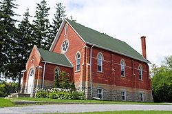
The present church structure, Locust Hill United Church, was built in 1890 (replacing earlier church on south side of Highway 7) [9] is shared site with Eastside Baptist Church. A cemetery is located across Highway 7 from the church and a cairn was added in the cemetery in 1990.

Future: Rouge National Park

While much of the city of Markham has become residential, the land immediately around Locust Hill is still in agricultural use. In 2011 the Canadian federal government announced plans to create a national Rouge Park. The park will completely encompass the community of Locust Hill. [10]

Transportation

The main roads linking Locust Hill is Highway 7 and Highway 407. The former was the main road into the hamlet. Reesor Road was used to reach the old school house.

Locust Hill Line

Metrolinx has a planned spur line off from the purposed Midtown corridor terminating a Locust Hill.

In film

Related Research Articles

<span class="mw-page-title-main">Markham, Ontario</span> City in Ontario, Canada

Markham is a city in the York Region of Ontario, Canada. It is approximately 30 km (19 mi) northeast of Downtown Toronto. In the 2021 Census, Markham had a population of 338,503, which ranked it the largest in York Region, fourth largest in the Greater Toronto Area (GTA), and 16th largest in Canada.

<span class="mw-page-title-main">Regional Municipality of York</span> Regional municipality in Ontario, Canada

The Regional Municipality of York, also called York Region, is a regional municipality in Southern Ontario, Canada, between Lake Simcoe and Toronto. The region was established after the passing of then Bill 102, An Act to Establish The Regional Municipality of York, in 1970. It replaced the former York County in 1971, and is part of the Greater Toronto Area and the inner ring of the Golden Horseshoe. The regional government is headquartered in Newmarket.

<span class="mw-page-title-main">Whitchurch-Stouffville</span> Town in Ontario, Canada

Whitchurch-Stouffville is a town in the Greater Toronto Area of Ontario, Canada, approximately 50 km (31 mi) north of downtown Toronto, and 55 km (34 mi) north-east of Toronto Pearson International Airport. It is 206.22 km2 (79.62 sq mi) in area, and located in the mid-eastern area of the Regional Municipality of York on the ecologically-sensitive Oak Ridges Moraine. Its motto since 1993 is "country close to the city".

<span class="mw-page-title-main">Rouge River (Ontario)</span> River in Ontario, Canada

The Rouge River is a river in Markham, Pickering, Richmond Hill and Toronto in the Greater Toronto Area of Ontario, Canada. The river flows from the Oak Ridges Moraine to Lake Ontario at the eastern border of Toronto, and is the location of Rouge Park, the only national park in Canada within a municipality. At its southern end, the Rouge River is the boundary between Toronto and southwestern Pickering in the Regional Municipality of Durham.

Stouffville is the primary urban area within the town of Whitchurch-Stouffville in York Region, Ontario, Canada. It is situated within the Greater Toronto Area and the inner ring of the Golden Horseshoe. The urban area is centred at the intersection of Main Street, Mill Street, and Market Street. Between 2006 and 2011, the population of the Community of Stouffville grew 100.5% from 12,411 to 24,886, or from 51% to 66% of the total population of the larger town of Whitchurch-Stouffville. The population of Stouffville from the 2021 census is 36,753.

<span class="mw-page-title-main">Finch Avenue</span> Road in Toronto, Ontario, Canada

Finch Avenue is an arterial thoroughfare that travels east–west in Toronto, Ontario, Canada. The road continues west into the Regional Municipality of Peel as Regional Road 2 and east into the Regional Municipality of Durham as Regional Road 37.

<span class="mw-page-title-main">Malvern, Toronto</span> Neighbourhood in Toronto, Ontario, Canada

Malvern is a neighbourhood in the city of Toronto, Ontario, Canada, with a population of 44,315. It is located in the northeast corner of the city.

<span class="mw-page-title-main">Cornell, Markham</span> Unincorporated community in Ontario, Canada

Cornell is a new community village being developed in northeast Markham, Ontario and bounded by Highway 407, 16th Avenue, Ninth Line, and the Donald Cousens Parkway. The 2011 population of this area was 9,880. Adding Cornell North's 2,178 it had 12,058 residents.

<span class="mw-page-title-main">Gormley, Ontario</span> Unincorporated community in Ontario, Canada

Gormley is a hamlet in York Region, Ontario, Canada that overlaps parts of Richmond Hill, and Whitchurch–Stouffville, two municipalities within the Greater Toronto Area. It was divided into two parts due to the construction of Highway 404. A portion of Gormley situated within Richmond Hill's political boundaries is subject to "Heritage Conservation District" controls. A post office in Gormley (East) serves as the mailing address for the Whitchurch–Stouffville communities of Bethesda, Gormley, Preston Lake, Vandorf, and Wesley Corners.

Box Grove(Census Tract 5350400.01) is an original community in Markham, Ontario.

Cedar Grove is a community in Markham, Ontario on the Little Rouge River. It is centred on 14th Avenue and Reesor Road and within the boundaries of the future national Rouge Park.

Dickson Hill is a small community in northeast Markham, Ontario, Canada, located near Highway 48 and 19th Avenue, on the border to Whitchurch-Stouffville.

Vinegar Hill is an unincorporated community in Markham, Ontario, Canada bounded by Highway 7 to the north, Highway 407 to the south, and streets just west and east of Main Street South, bordered by the Rouge River. The name of the community is believed to be linked to a cider mill on the east side of the river valley or barrel makers that filled them with vinegar to test their straightness when rolling down Markham Road.

<span class="mw-page-title-main">Donald Cousens Parkway</span> Arterial bypass of Markham

Donald Cousens Parkway or York Regional Road 48, also referred to historically as the Markham Bypass or Markham Bypass Extension, is a regionally-maintained arterial bypass of Markham in the Canadian province of Ontario. Named for former Markham mayor Don Cousens in April 2007, the route initially travelled northward from Copper Creek Drive in Box Grove, south of Highway 407, to Major Mackenzie Drive. A southern extension to Steeles Avenue was later completed and the name Donald Cousens Parkway applied along the extension to Ninth Line. In addition to its role of funneling through-traffic around downtown Markham, the route serves as a boundary to residential development as land to the north and east are part of the protected Rouge National Urban Park and southwest limits of the planned Pickering Airport.

Mongolia is an historical community in Markham, Ontario centred on 10th Line and Elgin Mills Rd. East, immediately south of the Town of Whitchurch-Stouffville. The hamlet lies completely within the expropriated federal Pickering Airport lands and also within the proposed boundaries of a future national Rouge Park.

Markham Village is the historic town centre of Markham, Ontario, Canada. Originally settled in 1825, the village, which was originally named "Reesorville" sometime after 1804 and also known as "Mannheim", was founded by Mennonites from Upstate New York and Pennsylvania. Eventually, as Upper Canada started to experience immigration from the British Isles, Markham would experience significant growth. By 1825, the name "Markham" was established as the permanent name. In 1850, it was established as a police village, and in 1873 was fully incorporated as a village within York County. Markham was amalgamated with the surrounding Markham Township, which included the villages of Unionville and Thornhill in 1971, and incorporated as a town.

Milnesville is a historic community of Markham, Ontario on the 8th Line or 8th Concession Road, between Elgin Mills Road and Major Mackenze Drive, and the Little Rouge Creek.

<span class="mw-page-title-main">Peter Reesor</span>

Peter Reesor was one of the original settlers of Markham, Ontario.

Old Bailey Bridge is a Bailey bridge located below 16th Avenue east of Reesor Road within Rouge Park in Markham, Ontario, Canada. The bridge crossed the Little Rouge Creek, a tributary of the Rouge River. A new bridge was built above this bridge to provide two way access for 16th Avenue east of Ressor Road. The old bridge is in situ with ends fenced off to prevent trespassing.

References

  1. For a full account of Locust Hill's history, cf. Isabel Champion, ed., Markham: 1793-1900 (Markham, ON: Markham Historical Society, 1979), pp. 246-248; 160; 183ff.; 89. See also Myra Chepack, "Markham Fair President 1910: James McCreight Armstrong [ permanent dead link ]," Markham Fair official website. Esther Reesor Armstrong was a daughter of Peter Reesor, founder of Reesorville, later the Village of Markham.
  2. "History of Belford". Pickering-Ajax Digital Archive. Archived from the original on April 10, 2016.
  3. 1 2 "Old Time Trains: Locust Hill". Trainweb.org. Retrieved November 20, 2020.
  4. "The Creamery". Pickering-Ajax Digital Archive. Archived from the original on April 10, 2016.
  5. Brown, Ron (2014-08-19). The Train Doesn't Stop Here Anymore: An Illustrated History of Railway Stations in Canada. ISBN   9781459727830.
  6. https://pub-markham.escribemeetings.com/filestream.ashx?documentid=4122 [ bare URL PDF ]
  7. Detailed 1878 map, "Township of Markham," Illustrated historical atlas of the county of York and the township of West Gwillimbury & town of Bradford in the county of Simcoe, Ont. (Toronto: Miles & Co., 1878). Note that Locust Hill is not noted, only Belford.
  8. Kenter, Peter (July 28, 2017). "Old school masonry work stabilizes Locust Hill School House". ConstructConnect Canada, Inc. Retrieved November 20, 2020.
  9. See North Pickering Community Development Project, The Historical Complexities of Pickering, Markham, Scarborough and Uxbridge Archived 2011-09-28 at the Wayback Machine , Sept. 1973, pp. 52f.
  10. See the Rouge Park Alliance, Park Map Archived 2011-07-23 at the Wayback Machine .

43°53′27″N79°11′52″W / 43.89083°N 79.19778°W / 43.89083; -79.19778