
Bourbonnais is a village in Kankakee County, Illinois, United States. The population was 15,256 in the 2000 census, but had grown to 18,631 in the 2010 census. It is part of the Kankakee-Bourbonnais-Bradley Metropolitan Statistical Area.
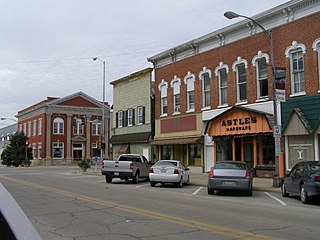
Momence is a city in Kankakee County, Illinois, United States. The population was 3,171 at the 2000 census, and 3,310 in 2010. It is part of the Kankakee–Bradley Metropolitan Statistical Area.
The Log Cabin Republicans (LCR) is an organization that works within the Republican Party to advocate equal rights for LGBT people in the United States.

A log cabin is a small log house, especially a less finished or architecturally sophisticated structure. Log cabins have an ancient history in Europe, and in America are often associated with first generation home building by settlers.

The Kankakee River is a tributary of the Illinois River, approximately 133 miles (214 km) long, in northwestern Indiana and northeastern Illinois in the United States. At one time, the river drained one of the largest wetlands in North America and furnished a significant portage between the Great Lakes and the Mississippi River. Significantly altered from its original channel, it flows through a primarily rural farming region of reclaimed cropland, south of Lake Michigan.
Illinois Route 114 is a rural east–west road that connects State Road 10 in Indiana, USA, with Illinois Route 1 and Illinois Route 17, which overlap in Momence. This is a distance of 7.40 miles (11.91 km).

Ernie's Grove is a small unincorporated community in King County, Washington, United States, near the North Fork of the Snoqualmie River outside the city of Snoqualmie.

Aroma Township is one of seventeen townships in Kankakee County, Illinois, USA. As of the 2010 census, its population was 5,157 and it contained 2,203 housing units.
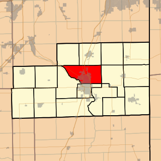
Bourbonnais Township is one of seventeen townships in Kankakee County, Illinois, USA. As of the 2010 census, its population was 40,137 and it contained 15,153 housing units.

Ganeer Township is one of seventeen townships in Kankakee County, Illinois, USA. As of the 2010 census, its population was 3,215 and it contained 1,411 housing units.

Kankakee River State Park is an Illinois state park on 4,000 acres (1,619 ha) primarily in Kankakee and Will Counties, Illinois, United States. Originally, 35 acres (14 ha) of land was donated by Ethel Sturges Dummer for the creation of the state park in 1938. Another 1,715 acres (694 ha) was donated by Commonwealth Edison in 1956, which again donated more land in 1989. The islands of Smith, Hoffman, Langham, and Willow are all located inside the park on the Kankakee River.

The Kankakee Outwash Plain is a flat plain interspersed with sand dunes in the Kankakee River valley in northwestern Indiana and northeastern Illinois of the United States. It is just south of the Valparaiso Moraine and was formed during the Wisconsin Glaciation. As the glacier, stopped at the Valparaiso Moraine, melted, the meltwater was carried away to the outwash plain. On the south side of the moraine, where the elevation drops, the meltwaters eroded away valleys, carrying sand and mud with them. As the muddy meltwater reached the valley where the slope lessened, the water slowed down, depositing the sand on the outwash plain. This created a smooth, flat, and sandy plain. Before its draining, the Kankakee Marsh, located on the outwash plain, was one of the largest freshwater marshes in the United States.

The Log Cabin Motel, also known as Camp O' The Pines in Pinedale, Wyoming, United States, was built in 1929 as a cabin camp to serve growing numbers of automobile-borne tourists bound for Yellowstone National Park. The camp was owned by Walter Scott, who operated the Pinedale Cash Store. Contrary to the name, Scott allowed customers to buy on credit, and some worked off their credit by building cabins at Camp O' The Pines. Unlike many auto camps, the camp was open year-round, with cabins often rented by the month by local people.

Elsie is an unincorporated community in Clatsop County, Oregon, United States. It is located in the Northern Oregon Coast Range, west of the junction of Oregon Route 103 and U.S. Route 26 where the roads cross the Nehalem River.
Ahern is an unincorporated community in Kankakee County, Illinois, United States. Ahern is located on Illinois Route 114, 3 miles (4.8 km) east-southeast of Momence.
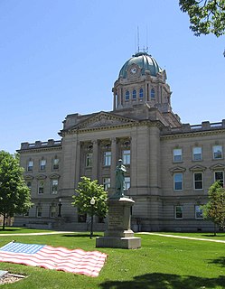
The Kankakee County Courthouse in Courthouse Square is a historic building in Kankakee, Illinois, United States that has been home to the government of Kankakee County since 1912. The current structure, the third county courthouse, took three years to build and is considered a fine example of Beaux-Arts architecture.

Lake Kankakee formed 14,000 years before present (YBP) in the valley of the Kankakee River. It developed from the outwash of the Michigan Lobe, Saginaw Lobe, and the Huron-Erie Lobe of the Wisconsin glaciation. These three ice sheets formed a basin across Northwestern Indiana. It was a time when the glaciers were receding, but had stopped for a thousand years in these locations. The lake drained about 13,000 YBP, until reaching the level of the Momence Ledge. The outcropping of limestone created an artificial base level, holding water throughout the upper basin, creating the Grand Kankakee Marsh.
Illiana Heights is an unincorporated community in Kankakee County, Illinois, United States. The community is located on the Kankakee River 6.3 miles (10.1 km) east of Momence.


