
Abraham Lincoln Capital Airport is a civil-military airport in Sangamon County, Illinois, United States, three miles (6 km) northwest of downtown Springfield. It is owned by the Springfield Airport Authority (SAA).

Ann Arbor Municipal Airport is a general aviation airport in Washtenaw County, Michigan, United States. It is included in the Federal Aviation Administration (FAA) National Plan of Integrated Airport Systems for 2017 to 2021, in which it is categorized as a regional general aviation facility.
Huron County Memorial Airport is a county-owned, public-use airport located one nautical mile (1.85 km) south of the central business district of Bad Axe, a city in Huron County, Michigan, United States. It is included in the Federal Aviation Administration (FAA) National Plan of Integrated Airport Systems for 2017–2021, in which it is categorized as a local general aviation facility.

Monroe County Airport is a county-owned public-use airport located four nautical miles southwest of the central business district of Bloomington, a city in Monroe County, Indiana, United States. Commercial service has been available at different points in the airport's history but as of today and for the future, no scheduled service is available.
Delaware Airpark is a public use airport serving the Dover area. It is owned by the Delaware Department of Transportation and operated by the Delaware River and Bay Authority and located one nautical mile (2 km) west of the central business district of Cheswold, a town in Kent County, Delaware, United States. It is included in the Federal Aviation Administration (FAA) National Plan of Integrated Airport Systems for 2017–2021, in which it is categorized as a local general aviation facility.
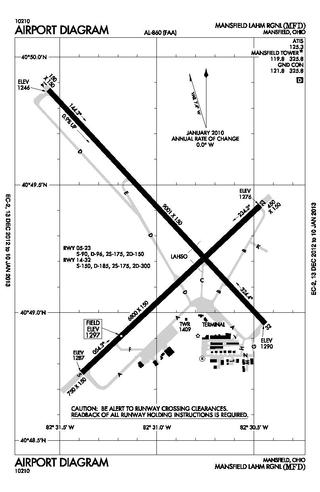
Mansfield Lahm Regional Airport is three miles (5 km) north of Mansfield, in Richland County, Ohio. By car the airport is an hour away from Cleveland and Columbus, near Interstate I-71, US Rt 30, State Route 13.
Grosse Ile Municipal Airport is on Grosse Ile, in Wayne County, Michigan. It is owned by the Township of Grosse Ile. The Federal Aviation Administration (FAA) National Plan of Integrated Airport Systems for 2017–2021 categorized it as a local reliever airport facility.

Gratiot Community Airport is a public use airport located three nautical miles (6 km) southwest of the central business district of Alma, a city in Gratiot County, Michigan, United States. It is owned by the city and county. It is included in the Federal Aviation Administration (FAA) National Plan of Integrated Airport Systems for 2017–2021, in which it is categorized as a local general aviation facility.
Drummond Island Airport is a public airport located one mile (2 km) southwest of the central business district of Drummond Island, in Chippewa County, Michigan, United States. It is owned by Drummond Township. It is included in the Federal Aviation Administration (FAA) National Plan of Integrated Airport Systems for 2017–2021, in which it is categorized as a basic general aviation facility.

Middletown Regional Airport, also known as Hook Field, is a city-owned public-use airport located two nautical miles (3.7 km) north of the central business district of Middletown, a city in Butler County, Ohio, United States. The airport was renamed in October 2008; it was previously known as Hook Field Municipal Airport.
Newark–Heath Airport is a public airport located in Heath, Ohio. It is three miles (4.8 km) southwest of the central business district of Newark, a city in Licking County, Ohio, United States. The airport was opened in 1930 by the city of Newark, and was transferred to the Licking County Regional Airport Authority in 1967. The airport currently has a McDonnell Douglas F-4C Phantom II S.N. 64–0683 on static display.

Canton–Plymouth Mettetal Airport is a public use airport located in Canton Township, Michigan, United States. The airport lies two nautical miles (3.7 km) south of the central business district of Plymouth, in Wayne County. The airport is owned and operated by the Michigan Department of Transportation (MDOT). It is also referred to as Mettetal Airport. The airport is uncontrolled (non-towered), and is used for general aviation purposes.
Fairfield County Airport is a public use airport in Fairfield County, Ohio, United States. It is located three nautical miles (6 km) northwest of the central business district of Lancaster, the county seat. The airport is owned by the Fairfield County Commissioners.
Highland County Airport is a public-owned, public-use airport located at 9500 North Shore Drive three nautical mile (4.8 km) southeast of the central business district of the city of Hillsboro, in Highland County, Ohio, United States.
Kennett Memorial Airport is a city-owned, public-use airport located one nautical mile (1.85 km) southeast of the central business district of Kennett, a city in Dunklin County, Missouri, United States. This airport is included in the National Plan of Integrated Airport Systems, which categorized it as a general aviation facility.
Penn Valley Airport is a public airport a mile north of Selinsgrove, a borough in Snyder County, Pennsylvania. It is owned by the Penn Valley Airport Authority. The National Plan of Integrated Airport Systems for 2011–2015 categorized it as a general aviation facility.
The Youngstown Elser Metro Airport is a privately owned, public use general aviation airport located 7 miles southwest of Youngstown in Beaver Township, Mahoning County, Ohio, United States. It has a 10/28 asphalt runway of 4,012 ft × 50 ft in dimension.

Geauga County Airport, is a public use airport in southern Geauga County, Ohio, United States. Owned and operated by Geauga County since 1968, it serves all of Geauga County. The airport is located 40 nautical miles east of downtown Cleveland.
Ontonagon County Airport, also known as Schuster Field, is a county-owned public-use airport located 3 miles (5 km) west of the central business district of Ontonagon, Michigan, a village in Ontonagon County, Michigan, United States. It is included in the Federal Aviation Administration (FAA) National Plan of Integrated Airport Systems for 2021–2025, in which it is categorized as a basic general aviation facility.
Sparta Community Airport, also known as Hunter Field, is a civil, public use airport 2 miles north of Sparta in Randolph County, Illinois. The airport is publicly owned by the Sparta Community Airport Authority.

