Long Creek, Illinois

Last updated

Long Creek, Illinois
Macon County Illinois Incorporated and Unincorporated areas Long Creek Highlighted.svg
Location in Macon County, Illinois
Usa edcp location map.svg
Red pog.svg
Long Creek
Location in the United States
Coordinates: 39°48′32″N88°51′24″W / 39.80889°N 88.85667°W / 39.80889; -88.85667
CountryUnited States
StateIllinois
County Macon
Township Long Creek
Area
[1]
  Total2.83 sq mi (7.32 km2)
  Land2.83 sq mi (7.32 km2)
  Water0.00 sq mi (0.00 km2)
Elevation
672 ft (205 m)
Population
 (2020) [2]
  Total1,261
  Density446.37/sq mi (172.34/km2)
Time zone UTC-6 (CST)
  Summer (DST) UTC-5 (CDT)
ZIP code
62521
Area code 217
FIPS code 17-44498

Long Creek is a village in Macon County, Illinois, United States. As of the 2020 census there were 1,261 people. [2] It is included in the Decatur, Illinois Metropolitan Statistical Area.

Contents

History

Long Creek is named for the creek that runs through the area.

The first settlers arrived in 1828 from North Carolina and subsequently built log cabins and made improvements on the surrounding land. [3] In the fall of 1828, a band of Native Americans from the Kickapoo Tribe of Oklahoma arrived and set up camp along Long Creek and began trapping, hunting, and fishing. When they were relatively unsuccessful at catching game, the Kickapoo began killing hogs and stealing poultry from the early settlers. Eventually a group of settlers drove them from the county.

During the early 1830s the area saw more settlers arriving, and the first schoolhouse was constructed in 1834. The school also served as a place of worship before the first church was built in 1842. [4]

Geography

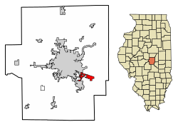
Long Creek is located in eastern Macon County at 39°48′32″N88°51′24″W / 39.80889°N 88.85667°W / 39.80889; -88.85667 (39.808936, -88.856548). [5] It is bordered to the northwest by the city of Decatur, the county seat, and to the southwest by the village of Mount Zion. U.S. Route 36 runs along the northern edge of Long Creek village, leading northwest 6 miles (10 km) to the center of Decatur and east 31 miles (50 km) to Tuscola.

According to the U.S. Census Bureau, the village of Long Creek has a total area of 2.83 square miles (7.33 km2), all land. [1] Long Creek flows through the center of the village limits, running west to Finley Creek at the southeast arm of Lake Decatur, a reservoir on the Sangamon River.

Demographics

Historical population
CensusPop.Note
1990 1,250
2000 1,3649.1%
2010 1,328−2.6%
2020 1,261−5.0%
U.S. Decennial Census [6]

As of the census [7] of 2000, there were 1,364 people, 486 households, and 408 families residing in the village. The population density was 513.2 inhabitants per square mile (198.1/km2). There were 500 housing units at an average density of 188.1 per square mile (72.6/km2). The racial makeup of the village was 98.61% White, 0.44% African American, 0.15% Native American, 0.29% Asian, 0.07% from other races, and 0.44% from two or more races. Hispanic or Latino people of any race were 0.51% of the population.

There were 486 households, out of which 38.5% had children under the age of 18 living with them, 74.1% were married couples living together, 5.6% had a female householder with no husband present, and 16.0% were non-families. 13.8% of all households were made up of individuals, and 6.6% had someone living alone who was 65 years of age or older. The average household size was 2.81 and the average family size was 3.08.

In the village, the population was spread out, with 27.7% under the age of 18, 5.6% from 18 to 24, 29.4% from 25 to 44, 28.3% from 45 to 64, and 8.9% who were 65 years of age or older. The median age was 39 years. For every 100 females, there were 98.8 males. For every 100 females age 18 and over, there were 104.6 males.

The median income for a household in the village was $56,083, and the median income for a family was $58,056. Males had a median income of $43,958 versus $27,344 for females. The per capita income for the village was $23,141. About 3.5% of families and 5.1% of the population were below the poverty line, including 7.4% of those under age 18 and 2.2% of those age 65 or over.

Related Research Articles

<span class="mw-page-title-main">Macon County, Illinois</span> County in Illinois, United States

Macon County is a county located in the U.S. state of Illinois. According to the 2020 United States Census, it had a population of 103,998. Its county seat and most populous city is Decatur.

<span class="mw-page-title-main">Waynesville, Illinois</span> Village in Illinois, United States

Waynesville is a village in DeWitt County, Illinois, United States. The population was 381 at the 2020 census.

<span class="mw-page-title-main">Argenta, Illinois</span> Village in Illinois, United States

Argenta is a village in Macon County, Illinois, United States, whose population was 913 at the 2020 census. It is included in the Decatur, Illinois Metropolitan Statistical Area.

<span class="mw-page-title-main">Blue Mound, Illinois</span> Village in Illinois, United States

Blue Mound is a village in Macon County, Illinois, United States. The population was 1,133 at the 2020 census. It is included in the Decatur, Illinois Metropolitan Statistical Area.

<span class="mw-page-title-main">Forsyth, Illinois</span> Village in Illinois, United States

Forsyth is a village in Macon County, Illinois, United States. Its population was 3,734 at the 2020 census, up from 3,490 in 2010. It is included in the Decatur, Illinois Metropolitan Statistical Area.

<span class="mw-page-title-main">Harristown, Illinois</span> Village in Illinois, United States

Harristown is a village in Macon County, Illinois, United States. The population was 1,310 at the 2020 census. It is included in the Decatur, Illinois Metropolitan Statistical Area.

<span class="mw-page-title-main">Macon, Illinois</span> City in Illinois, United States

Macon is a town in Macon County, Illinois, United States whose population was 1,177 at the 2020 census. It is included in the Decatur, Illinois Metropolitan Statistical Area and lies 9 miles (14 km) south of Decatur.

<span class="mw-page-title-main">Maroa, Illinois</span> City in Illinois, United States

Maroa is a city in Macon County, Illinois, United States. Its population was 1,577 at the 2020 census, down from 1,801 in 2010. It is included in the Decatur, Illinois Metropolitan Statistical Area.

<span class="mw-page-title-main">Niantic, Illinois</span> Village in Illinois, United States

Niantic is a village in Macon County, Illinois, United States. Its population was 612 at the 2020 census, down from 707 in 2010. It is included in the Decatur, Illinois Metropolitan Statistical Area.

<span class="mw-page-title-main">Oreana, Illinois</span> Village in Illinois, United States

Oreana is a village in Macon County, Illinois, United States, which had a population of 891 at the 2020 census. It is included in the Decatur, Illinois Metropolitan Statistical Area.

<span class="mw-page-title-main">Warrensburg, Illinois</span> Village in Illinois, United States

Warrensburg is a village in Macon County, Illinois, United States. Its population was 1,110 at the 2020 census, down from 1,201 in 2010. It is included in the Decatur, Illinois Metropolitan Statistical Area. Warrensburg was established in 1841.

<span class="mw-page-title-main">Scottville, Illinois</span> Village in Illinois, United States

Scottville is a village in Macoupin County, Illinois, United States. The population was 93 at the 2020 census.

<span class="mw-page-title-main">Worden, Illinois</span> Village in Illinois, United States

Worden is a village in Madison County, Illinois, United States. The population was 1,096 at the 2020 census.

<span class="mw-page-title-main">Blandinsville, Illinois</span> Village in Illinois, United States

Blandinsville is a village in McDonough County, Illinois, United States. The population was 569 at the 2020 census, down from 651 in 2010.

<span class="mw-page-title-main">Downs, Illinois</span> Village in Illinois, United States

Downs is a village in McLean County, Illinois, United States. The population was 1,201 at the 2020 census, up from 1,005 in 2010. It is part of the Bloomington–Normal Metropolitan Statistical Area.

<span class="mw-page-title-main">Heyworth, Illinois</span> Village in Illinois, United States

Heyworth is a village in McLean County, Illinois, United States. It was founded in 1859. As of the 2020 census, Heyworth had a population of 2,791. It is part of the Bloomington–Normal Metropolitan Statistical Area.

<span class="mw-page-title-main">Alexis, Illinois</span> Village in Illinois, United States

Alexis is a village in Mercer and Warren counties in Illinois, United States. The population was 793 at the 2020 census.

<span class="mw-page-title-main">Auburn, West Virginia</span> Town in West Virginia, United States

Auburn is a town in Ritchie County, West Virginia, United States. The population was 80 at the 2020 census.

Adams is a village in the town of Adams in Jefferson County, New York, United States. The population was 1,775 at the 2010 census. The village is named after President John Adams.

<span class="mw-page-title-main">Mount Zion, Illinois</span> Village in Illinois, United States

Mount Zion is a village in Macon County, Illinois, United States. The population was 6,019 at the 2020 census.

References

  1. 1 2 "2022 U.S. Gazetteer Files: Illinois". United States Census Bureau. Retrieved February 6, 2023.
  2. 1 2 "P1. Race – Long Creek village, Illinois: 2020 DEC Redistricting Data (PL 94-171)". U.S. Census Bureau. Retrieved February 6, 2023.
  3. "Long Creek Township History" . Retrieved September 17, 2018.
  4. "History of Long Creek, Illinois" . Retrieved September 17, 2018.
  5. "US Gazetteer files: 2010, 2000, and 1990". United States Census Bureau. February 12, 2011. Retrieved April 23, 2011.
  6. "Census of Population and Housing". Census.gov. Retrieved June 4, 2015.
  7. "U.S. Census website". United States Census Bureau . Retrieved January 31, 2008.