Long Kin East Cave - Rift Pot System

Last updated

Long Kin East - Rift Pot System
Rift-pot-entrance-on-ingleborough.jpg
A caver descending the entrance pitch of Rift Pot
Yorkshire Dales NP map-pre-2016.svg
Red pog.svg
Location Ingleborough, North Yorkshire, England
OS grid SD 7624 7307
Coordinates 54°09′11″N2°21′55″W / 54.152966°N 2.365236°W / 54.152966; -2.365236
Depth116 metres (381 ft) [1]
Length1.5 kilometres (0.93 mi) [1]
Elevation411 metres (1,348 ft) [1]
Discovery1904
Geology Carboniferous limestone
Entrances5
Hazardsverticality, water, boulders [1]
Access Booking required
Cave survey On Cave Mapper

The Long Kin East Cave - Rift Pot system is a limestone cave system on the southern flanks of Ingleborough, North Yorkshire in England lying within the designated Ingleborough Site of Special Scientific Interest. [2] Long Kin East Cave starts as a long meandering stream passage but then plummets down a 58-metre (190 ft) deep shaft when it meets a shattered fault into which Rift Pot also descends. At the bottom, the stream flows through some low canals and sumps, to eventually emerge at Austwick Beck Head in Crummackdale.

Contents

Description

The main entrance to Long Kin East Cave ( 54°09′11″N2°21′55″W / 54.152966°N 2.365236°W / 54.152966; -2.365236 ) is where a small stream sinks into a deepening fissure in a small exposure of limestone rocks located in an extensive area of moorland. The fissure gains a roof and morphs into a walking-sized meandering stream passage, passing an alternative dry entrance at the first corner. After 216 metres (709 ft) the passage passes below a walled-off pothole ( 54°09′06″N2°21′57″W / 54.151669°N 2.365922°W / 54.151669; -2.365922 ) where daylight enters. After a further 43 metres (141 ft) an ascent up a slope of rocks leads to the bottom of the Long Kin East Pot entrance - a 4-metre (13 ft) deep shaft ( 54°09′05″N2°21′56″W / 54.151351°N 2.365672°W / 54.151351; -2.365672 ). [1]

A route through the boulders at the bottom of the Long Kin East entrance drops into the continuation of the stream passage. This continues for a further 216 metres (709 ft) where it starts to descend a succession of small cascades and pitches. A final cascade leads into a chamber overlooking a 58-metre (190 ft) deep shaft, at the bottom of which is an elongated rift chamber formed within a fault. [1] Upstream ascends a boulder slope where various routes from Rift Pot enter. Downstream, a mud slope drops into a stream passage, which continues upstream as a series of oxbows that reappear in the chamber. The stream continues low and wide to a junction. Downstream continues to a 20-metre (66 ft) long sump that emerges in a 25-metre (82 ft) long canal at the end of which is a second sump. This has been explored for 120 metres (390 ft). [1] [3] Upstream from the junction, a wet crawl reaches some gour pools in a walking-sized passage, before continuing as a crawl which chokes just to the east of Jockey Hole. [1]

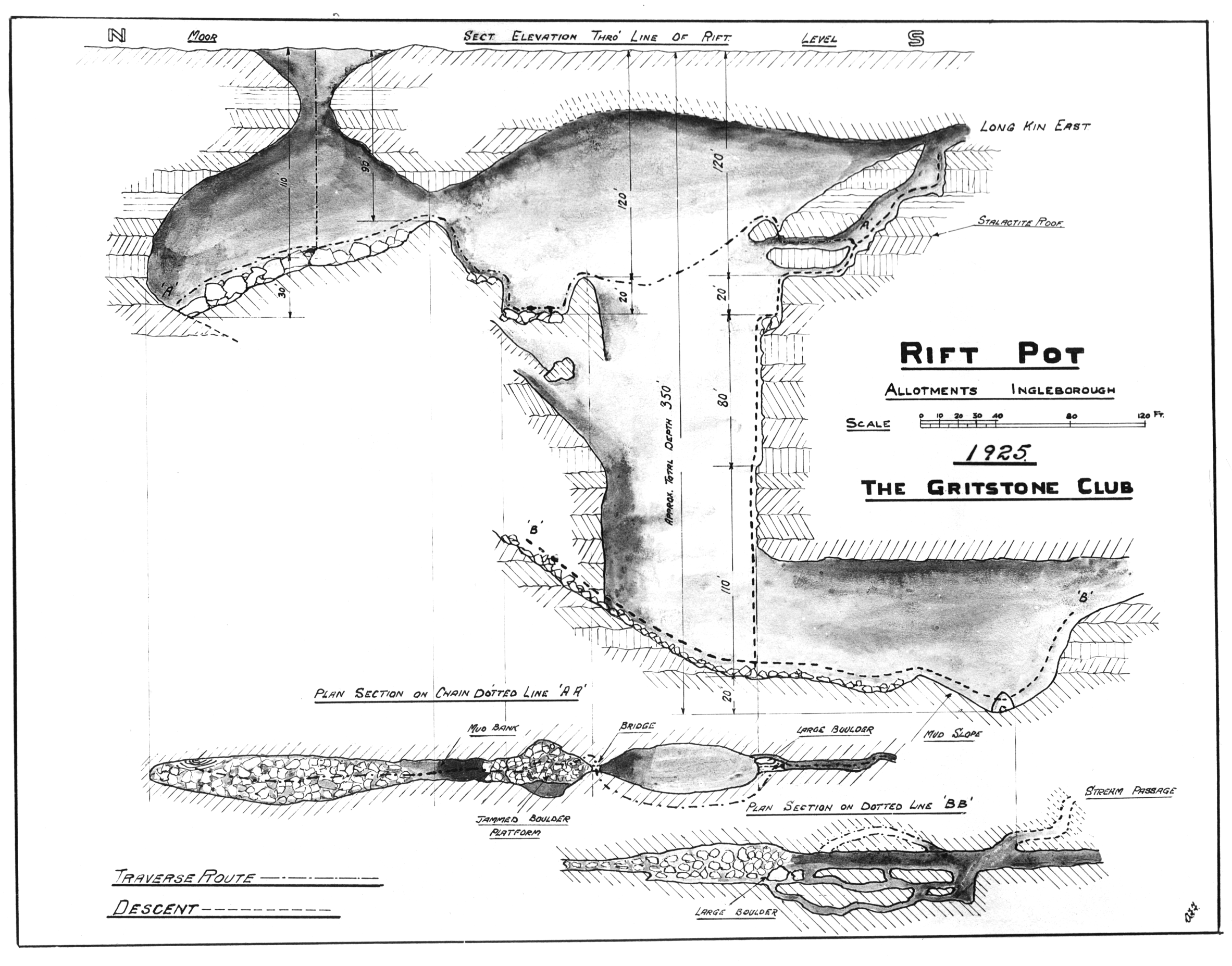
A few metres back from the chamber overlooking the main pitch, a bedding traverse in the roof of the passage leads to a high chamber overlooking the shaft. A boulder slope can be followed round the chamber to a rock bridge crossing the rift. A short descent from The Bridge leads into Rift Pot (see below). [1]

The Rift Pot entrance ( 54°09′05″N2°22′03″W / 54.151379°N 2.367571°W / 54.151379; -2.367571 ) is located on the same major fault as is seen underground. The 60-metre (200 ft) deep shaft of Jockey Hole lies 65 metres (71 yd) further up on the same fault. The entrance shaft drops 34 metres (112 ft) into a large chamber. The chamber is blind to the north, but an ascent of boulders on the south side climbs up into one end of the enormous fault chamber, at the far end of which enters Long Kin East Cave. Two small pitches over boulders lead to a boulder platform below The Bridge, from the top of which a traverse leads back into Long Kin East Cave. From the platform, a variety of routes may be descended to the floor of the chamber, 60 metres (200 ft) below, between the various jammed boulder platforms that partition the chamber. One route which does not descend through the boulders is the 68 Series, which start as a bedding plane passage leading off from a boulder chamber 37 metres (121 ft) above the floor. This complex of passages is about 122 metres (400 ft) long, one branch of which descends a succession of small pitches to finish at a window overlooking the bottom of the chamber some 9 metres (30 ft) above the floor. [4]

Both Rift Pot and Long Kin East Cave have been equipped with resin P-hangers allowing cavers to follow a number of different routes to the bottom using single rope techniques. [5] [6]

Geology and hydrology

The Long Kin East system is a solutional cave formed in Visean Great Scar limestone from the Mississippian Series of the Carboniferous period. [7] The entrance to Long Kin East Cave is close to the limestone margin where a small stream, with a mean flow of about 30 litres per second (6.6 impgal/s), sinks into the limestone. [8] [9] The entrance passage is a meandering vadose canyon which descends gradually following the local southerly dip before reaching the main shaft. This, and Rift Pot, are formed in the breccia and shear zone of a major fault. [8] [9] Exploration of the phreatic stream passage at the bottom of the shaft has reached a point which is 11 metres (36 ft) above and about 2 kilometres (1.2 mi) distant from the resurgence at Austwick Beck Head in Crummackdale. [10]

History

There is a mention of Long Kin in an article published in The Gentleman's Magazine , by Pastor, know to be a pseudonym for John Hutton, in March 1761, but despite associating it with the near-by Jockey Hole the description matches neither Rift Pot nor Long East Cave: "There is, likewise, partly south-east, a small rivulet which falls into a place considerable deep, called Long-Kin;". [11] [12] It is clear that the first part of Long Kin East Cave had been explored as far as the skylight entrances by 1889, as a paper published in the Leeds Geological Association Transactions says: "these being three fissures connected by a subterranean passage, through which a small stream flows". [13] A detailed description of the cave was given by Balderstone in Ingleton: Bygone and Present, published in 1890, but it seems that he did not reach as far as the two skylight entries. He also describes two surface shafts he called "Long Kin Holes". It is clear from the description that one of them was what is now known as Jockey Hole, but the other was the then unnamed Rift Pot, which he plumbed to a depth of 35 metres (115 ft). [14] The hydrological connection between Long Kin East Cave and Austwick Beck Head was established in 1900 using fluorescein by the Yorkshire Geological Society. [10]

Rift Pot was first descended in 1904 by members of the Yorkshire Ramblers Club. The full descent was made over three separate days, with the party being hampered by a large quantity of loose rock. They named the pothole, Rift Pot, "because of its characteristic form, it being literally a huge vertical rift in the limestone". [15] In 1904 a party the Yorkshire Speleological Association (YSA) including Eli Simpson, dug through the boulders at the bottom of what is now known as Long Kin East Pot, to reach the continuation of the Long Kin East Cave streamway. Two more explorations took place in 1904 and 1905, but it is unclear how far was reached. In 1906 the YSA followed the stream through to the head of the 58-metre (190 ft) shaft which drops in the final chamber of Rift Pot. They also discovered the traverse over the head of the big pitch leading to the top of The Bridge in Rift Pot from where they could discern daylight filtering through from ahead. [16] The connection between the two caves was made in 1908 when a YSA group who had descended Long Kin East Cave hung a ladder from the bridge and joined a party who had descended Rift Pot. [17] The first descent of the big pitch in Long Kin East was made in 1925 by members of the Gritstone Club, when they also produced a survey of the relationship between the two caves. [18] [19] [20] The first mention of the upstream passages was in October 1969 when University of Leeds Speleological Association reported that they had surveyed them in 1967. [21] The 68 Series were explored in 1968 by members of the same club. [4]

The terminal sump was first dived by Dave Yeandle in 1975, but little progress was made in the low visibility. [22] Rick Stanton had three dives in 1987, to reach the current limit without reaching a positive conclusion. [23]

Related Research Articles

<span class="mw-page-title-main">Rowten Pot</span>

Rowten Pot is one of several entrances into the 27-kilometre (17 mi) long cave system that drains Kingsdale in North Yorkshire, England. Its entrance is a shaft some 27 metres (89 ft) long, 10 metres (33 ft) wide, and at the southern end 72 metres (236 ft) deep.

<span class="mw-page-title-main">Marble Arch Caves</span> Limestone caves in Northern Ireland

The Marble Arch Caves are a series of natural limestone caves located near the village of Florencecourt in County Fermanagh, Northern Ireland. The caves are named after the nearby Marble Arch, a natural limestone arch at the upstream end of Cladagh Glen under which the Cladagh River flows. The caves are formed from three rivers draining off the northern slopes of Cuilcagh mountain, which combine underground to form the Cladagh. On the surface, the river emerges from the largest karst resurgence in Ireland, and one of the largest in the United Kingdom. At 11.5 kilometres (7.1 mi) the Marble Arch Caves form the longest known cave system in Northern Ireland, and the karst is considered to be among the finest in the British Isles.

<span class="mw-page-title-main">Rumbling Hole</span> Cave in Lancashire, England

Rumbling Hole is a cave on Leck Fell, in Lancashire, England. Its entrance is a 50-metre (160 ft) deep fenced shaft, and it rapidly descends a series of pitches to a low aqueous passage that has been connected to Lost Johns' Cave. It is part of the Three Counties System, an 87-kilometre (54 mi) cave system that spans the borders of Cumbria, Lancashire, and North Yorkshire.

<span class="mw-page-title-main">Simpson Pot</span> Cave in North Yorkshire, England

Named after Eli Simpson, Simpson Pot is a limestone cave in West Kingsdale, North Yorkshire, England. It leads into Swinsto Cave and thence into Kingsdale Master Cave, and it is popular with cavers as it is possible to descend it by abseiling down the pitches, retrieving the rope each time, and exiting through Valley Entrance of Kingsdale Master Cave at the base of the hill. It is part of a 27-kilometre (17 mi) long cave system that drains both flanks of Kingsdale.

<span class="mw-page-title-main">Langcliffe Pot</span> Cave system in North Yorkshire

Langcliffe Pot is a cave system on the slopes of Great Whernside in Upper Wharfedale, about 3 kilometres (1.9 mi) SSE of Kettlewell in North Yorkshire. It is part of the Black Keld Site of Special Scientific Interest where the "underground drainage system which feeds the stream resurgence at Black Keld is one of the largest and deepest in Britain, although only a small proportion of its cave passages are accessible at present." Mossdale Caverns is also part of the Black Keld SSSI. Although a considerable length of passage has been explored in Langcliffe Pot, the current end is over 170 metres (560 ft) above the resurgence, and over 4 kilometres (2.5 mi) in distance. A trip to the far end has been described as "one of the most serious undertakings in British caving".

<span class="mw-page-title-main">Shannon Cave</span> Cave in the island of Ireland that feeds Shannon Pot

Shannon Cave is an active stream passage cave which straddles the border of County Fermanagh, Northern Ireland and County Cavan in the Republic of Ireland.

<span class="mw-page-title-main">Aquamole Pot</span> Cave in North Yorkshire, England

Aquamole Pot is a limestone cave in West Kingsdale, North Yorkshire, England. It was originally discovered by cave divers who negotiated 168 metres (551 ft) of sump passage from Rowten Pot in 1974, to enter a high aven above the river passage. All subsequent major explorations were undertaken from below before an entrance was opened up from the surface. It is part of a 27-kilometre (17 mi) long cave system that drains both flanks of Kingsdale.

The Nidderdale Caves are a series of caves in Upper Nidderdale in North Yorkshire, England. There are two cave systems and most of the caves are in some way linked with one or the other. The smaller system is the Eglin cave system in the valley of How Stean Beck, a tributary of the River Nidd, associated with How Stean Gorge. The larger system is the Goyden cave system under the valley of the River Nidd, which flows east from Scar House Reservoir, then south, and shortly after disappears underground down several sink holes to reappear at the rising just beyond the village of Lofthouse. Cavers are able to access several sections of this system via the different entrances.

<span class="mw-page-title-main">Short Drop Cave - Gavel Pot System</span>

Short Drop Cave and Gavel Pot are different entrances into the same cave system on Leck Fell, in Lancashire, England. The main top entrance, Short Drop Cave, is a small hole in a fenced off shakehole near the main stream sink; Gavel Pot, a window into the system, is a large fenced shakehole some 40-metre (130 ft) deep requiring tackle to descend. There are two other smaller entrances into Short Drop Cave. At its base the system links via a sump with Lost Johns' Cave, and is part of the Three Counties System, an 87 kilometres (54 mi) cave system which spans the borders of Cumbria, Lancashire, and North Yorkshire.

<span class="mw-page-title-main">Bar Pot</span>

Bar Pot is one of the entrances to the Gaping Gill cave system being located about 340 metres (370 yd) south of Gaping Gill Main Shaft, on Ingleborough in the Yorkshire Dales. It is a popular entrance into the system, being one of the easiest, driest, and having just two vertical pitches to contend with. It lies within the designated Ingleborough Site of Special Scientific Interest.

<span class="mw-page-title-main">Disappointment Pot</span>

Disappointment Pot is one of the entrances to the Gaping Gill cave system, located in a steep grassy shakehole some 120 metres (130 yd) south-east of Gaping Gill Main Shaft. Its mainly narrow stream passage descends a number of small shafts to enter the main system as a major inlet of Hensler's Master Cave. It lies within the designated Ingleborough Site of Special Scientific Interest.

<span class="mw-page-title-main">Stream Passage Pot</span>

Stream Passage Pot is one of the entrances to the Gaping Gill system being located about 320 metres (350 yd) ESE of Gaping Gill Main Shaft. It is a popular and sporting entrance into the system, featuring three well-watered big shafts. It is the highest entrance of the Gaping Gill system, so the full depth of the system, 198 metres (650 ft), is measured from its entrance. It lies within the designated Ingleborough Site of Special Scientific Interest.

<span class="mw-page-title-main">Flood Entrance Pot</span>

Flood Entrance Pot is one of the entrances to the Gaping Gill cave system located about 300 metres (330 yd) south of Gaping Gill Main Shaft. It was the first alternative entrance into the main system to be explored, and it is now a popular entrance into the system, with a fine 38-metre (125 ft) pitch landing in Gaping Gill's South-East Passage. It lies within the designated Ingleborough Site of Special Scientific Interest.

<span class="mw-page-title-main">Skirwith Cave</span> Cave in North Yorkshire, England

Skirwith Cave is a major resurgence solutional cave on Ingleborough in Chapel-le-Dale, North Yorkshire, England; it was a show cave between 1964 and 1974. It is no longer open to the public but is still visited by cavers. It lies within the designated Ingleborough Site of Special Scientific Interest.

<span class="mw-page-title-main">Yordas Cave</span> Cave in North Yorkshire, England

Yordas Cave is a solutional cave in Kingsdale, North Yorkshire, England. It has been renowned since the eighteenth century as a natural curiosity, and was a show cave during the nineteenth century. It is now a popular destination for cavers, walkers, and outdoor activity groups.

<span class="mw-page-title-main">Death's Head Hole</span> Cave in Lancashire, England

Death's Head Hole is a cave on Leck Fell, in Lancashire, England. Its entrance is a 64-metre (210 ft) deep shaft. It leads into Lost Johns' Cave and is part of the Three Counties System, an 87-kilometre (54 mi) cave system which spans the borders of Cumbria, Lancashire, and North Yorkshire.

Lost Pot is a cave on Leck Fell, in Lancashire, England. It leads into the top end of Lost Johns' Cave, and is part of the Three Counties System, an 87 kilometres (54 mi) cave system which spans the borders of Cumbria, Lancashire, and North Yorkshire.

Long Drop Cave is a cave on Leck Fell, in Lancashire, England. It leads into Death's Head Hole, and is part of the Three Counties System, an 87-kilometre (54 mi) cave system which spans the borders of Cumbria, Lancashire, and North Yorkshire.

<span class="mw-page-title-main">Swinsto Cave</span> Cave in North Yorkshire, England

Swinsto Cave is a limestone cave in West Kingsdale, North Yorkshire, England. It leads into Kingsdale Master Cave and it is popular with cavers as it is possible to descend by abseiling down the pitches, retrieving the rope each time, and exiting through Valley Entrance of Kingsdale Master Cave at the base of the hill. It is part of a 27-kilometre (17 mi) long cave system that drains both flanks of Kingsdale.

<span class="mw-page-title-main">Jingling Pot</span> Cave in North Yorkshire, England

Jingling Pot is a limestone cave in West Kingsdale, North Yorkshire, England. Located adjacent to Jingling Beck, it is a lenticular-shaped 45-metre (148 ft) deep shaft that descends straight from the surface. At the bottom the rift extends to the north and descends steeply into a further chamber, at the end of which the initials of the original explorers may be seen scratched into the rock. A narrow shaft in this second chamber drops into a complex of small crawls and rifts, which approach close to a passage in the One-armed Bandit Series of Aquamole Pot. A second set of shafts descend parallel to the surface shaft. These can be entered through a rock window a little way below the entrance.

References

  1. 1 2 3 4 5 6 7 8 9 Brook, A.; Brook, D.; Griffiths, J.; Long, M.H. (1991). Northern Caves Volume 2. The Three Peaks. Clapham: The Dalesman Publishing Co. Ltd. pp. 159–160, 167–168. ISBN   1855680335.
  2. "Designated Sites View - Ingleborough SSI". Natural England. Retrieved 31 July 2021.
  3. Hill, Elaine; Hall, Adrian (2015). Northern Sump Index 2015 (3rd ed.). Cave Diving Group. p. 314. ISBN   9780901031082.
  4. 1 2 Monico, Paul (1989). "The 68 Pitches, 1968". University of Leeds Speleological Society Explorations Journal. 2: 94–95.
  5. "Long Kin East Cave and Pot". Council of Northern Caving Clubs. Retrieved 26 July 2021.
  6. "Rift Pot". Council of Northern Caving Clubs. Retrieved 26 July 2021.
  7. Waters, Colin; Lowe, David (2013). "Geology of the Limestones". In Waltham, Tony; Lowe, David (eds.). Caves and Karst of the Yorkshire Dales Volume 1. Great Hucklow, Buxton: British Cave Research Association. pp. 11–23. ISBN   9780900265471.
  8. 1 2 Waltham, Tony; Brook, Dave (2017). "Caves of Ingleborough". In Waltham, Tony; Lowe, David (eds.). Caves and Karst of the Yorkshire Dales Volume 2. Great Hucklow, Buxton: British Cave Research Association. p. 367. ISBN   9780900265518.
  9. 1 2 Waltham, A.C. (1974). Limestones and Caves of North-West England. Newton Abbey: David & Charles. p. 385. ISBN   0715361813.
  10. 1 2 Carter, W.L.; Dwerryhouse, A.R. (1904). "The Underground Waters of North-West Yorkshire. Part II. The Underground Waters of Ingleborough". Proceedings of the Yorkshire Geological Society. 15 (2): 248–304. doi:10.1144/pygs.15.2.248.
  11. Hutton, John (March 1761). "Account of Ingleborough, a Remarkable Mountain". The Gentleman's Magazine . XXXI: 126–128. Retrieved 26 July 2021.
  12. Shaw, Trevor R. (September 1971). "John Hutton, 1740? – 1806. His 'Tour to the Caves....' and his Place in the History of Speleology". Studies in Speleology. London: William Pengelly Cave Studies Trust. Vol 2., Parts 3–4 : 112.
  13. Hardcastle, C.D. (1890). "The Physical Features of Ingleton". Transactions of the Leeds Geological Association. 5: 19–20. Retrieved 18 July 2021.
  14. Balderstone, Robert; Balderstone, Margaret (1890). Ingleton: Bygone and Present. London: Simpkin, Marshall and Co. pp. 49–52.
  15. Booth, T.S. (1905). "Jockey Hole and Rift Pot". Yorkshire Ramblers' Club Journal. 2 (6): 145–156.
  16. Simpson, Eli (1907). "Rift Pot. Ingleborough" (PDF). Journal of the Yorkshire Speleological Association. 1 (1): 1–3. Retrieved 19 July 2021.
  17. Simpson, Eli (1909). "Long Kin East. Ingleborough" (PDF). Journal of the Yorkshire Speleological Association. 1 (2): 17–21. Retrieved 19 July 2021.
  18. Griffiths, G.E. (1926). "Potholing in 1925". Gritstone Club. 2 (3): 23–25.
  19. "Cave Exploration". Yorkshire Ramblers' Club Journal. 5 (17): 244. 1927.
  20. "Rift Pot Survey". Yorkshire Dales Cave Maps. Retrieved 26 July 2021.
  21. Brook, Dave; Crabtree, Howard (October 1967). "Survey on the Allotment". ULSA Explorations Journal. 1: 48.
  22. Yeandle, D.W. (October 1975). "Rift Pot". Cave Diving Group Newsletter. 37: 15.
  23. Stanton, Rick (October 1987). "Rift Pot". Cave Diving Group Newsletter. 85: 7–8.