Interstate 45 (I-45) is an interstate highway located entirely within the U.S. state of Texas. While most interstate routes ending in five are cross-country north-south routes, I-45 is comparatively short, with the entire route located in Texas. It connects the cities of Dallas and Houston, continuing southeast from Houston to Galveston over the Galveston Causeway to the Gulf of Mexico.
In geology, a fault is a planar fracture or discontinuity in a volume of rock, across which there has been significant displacement as a result of rock-mass movement. Large faults within the Earth's crust result from the action of plate tectonic forces, with the largest forming the boundaries between the plates, such as subduction zones or transform faults. Energy release associated with rapid movement on active faults is the cause of most earthquakes.

A frontage road is a local road running parallel to a higher-speed, limited-access road. A frontage road is often used to provide access to private driveways, shops, houses, industries or farms. Where parallel high-speed roads are provided as part of a major highway, these are also known as local-express lanes.
U.S. Highway 175 (US 175) is an east-west United States highway completely within the state of Texas. It comes very close to meeting its "parent" route, US 75, but decommissioning and rerouting in downtown Dallas, Texas brings it a couple of miles short. Before the decommissioning of US 75 south of downtown Dallas in favor of Interstate 45, US 175 met its "parent" US 75. US 175's western terminus is in Dallas, Texas at Interstate 45. The highway's eastern terminus is in Jacksonville, Texas at an intersection with US 69.
Sinistral and dextral, in some scientific fields, are the two types of chirality ("handedness") or relative direction.

U.S. Route 290 is an east–west U.S. Highway located entirely within the state of Texas. Its current western terminus is at Interstate 10 near Harper, and its eastern terminus is at Interstate 610 on the northwest side of Houston. It is the main highway between Houston and Austin and is a cutoff for travelers wanting to bypass San Antonio on Interstate 10.

Mount Bonnell, also known as Covert Park, is a prominent point alongside the Lake Austin portion of the Colorado River in Austin, Texas. It has been a popular tourist destination since the 1850s. The mount provides a vista for viewing the city of Austin, Lake Austin, and the surrounding hills. It was designated a Recorded Texas Historic Landmark in 1969, bearing Marker number 6473, and was listed on the National Register of Historic Places in 2015.

A Texas U-turn, or Texas turnaround, boomerang, or loop around, is a lane allowing cars traveling on one side of a one-way frontage road to U-turn onto the opposite frontage road. Typically controlled by yield signs, these allow U-turning traffic to bypass two traffic signals and avoid crossing the local traffic twice.

A stack interchange, or colloquially butterfly junction, is a particular, free-flowing type of design for interchanges, meaning grade-separated road junctions. It is referred to as a directional interchange in the American Association of State Highway and Transportation Officials Policy on Geometric Design of Highways and Streets.

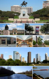
Houston, the most populous city in the Southern United States, is located along the upper Texas Gulf Coast, approximately 50 miles (80 km) northwest of the Gulf of Mexico at Galveston. The city, which is the ninth-largest in the United States by area, covers 601.7 square miles (1,558 km2), of which 579.4 square miles (1,501 km2), or 96.3%, is land and 22.3 square miles (58 km2), or 3.7%, is water.
Interstate 10 (I-10) is the major east–west Interstate Highway in the Southern United States. In the U.S. state of Texas, it runs east from Anthony, at the border with New Mexico, through El Paso, San Antonio and Houston to the border with Louisiana in Orange, Texas. At just under 880 miles (1,420 km), the Texas segment of I-10, maintained by the Texas Department of Transportation, is the longest continuous untolled freeway in North America that is operated by a single authority,. It is also the longest stretch of highway with a single designation within a single state. Mile marker 880 and its corresponding exit number in Orange, Texas, are the highest numbered mile marker and exit on any freeway in North America. After widening was completed in 2008, a portion of the highway west of Houston is now also believed to be the widest in the world, at 26 lanes. There is a wider section in China on the G4 Beijing–Hong Kong–Macau Expressway; however, that section is a toll plaza approach.

U.S. Highway 75 (US 75) in the state of Texas is a U.S. Highway that begins in Dallas and heads north to the Oklahoma state line.
Loop 289 is a multi-lane beltway servicing Lubbock as a freeway. The highway serves as the southern end for Interstate 27 on the south side of the city. The highway passes about a mile south of Lubbock Preston Smith International Airport on the north side near the intersection with I-27.

Long Point is an unincorporated area in Fort Bend County, Texas, United States. It is located 24 miles (39 km) southeast of Richmond, Texas at the intersection of Farm to Market Road 1994 and FM 361. There is no road sign identifying the community, though the nearby roads carry its name. Petroleum and sulphur were extracted near the community in the 1930s. Electric transmission towers pass through the site and a county landfill is located to the northeast.

Temple Butte, in the Grand Canyon, Arizona, USA is a prominence below the East Rim. The butte lies on the west bank of the south-flowing Colorado River. The outfall from the Little Colorado River, draining from the Painted Desert to the east and southeast, is about 2-mi upstream.

Isis Temple, in the Grand Canyon, Arizona, USA is a prominence below the North Rim, and adjacent Granite Gorge. The prominence lies north of the north bank of the west-flowing Colorado River, and is just north of Middle Granite Gorge. The Trinity Creek and canyon flow due-south at its west border; its north, and northeast border/flank is formed by Phantom Creek and canyon, a west tributary of Bright Angel Creek; the creeks intersect about 3 mi southeast, and 1 mi north of Granite Gorge.

Howellville or Howell is an unincorporated community in Harris County, Texas, United States, which has been absorbed by Greater Houston. The site is located at the intersection of Alief Clodine Road and Sugar Land Howell Road on the west side of Houston, approximately halfway between the original settlements of Clodine and Alief. There are no road signs identifying the place. The community began as a stop on a railroad line that no longer exists.

This is a list of the National Register of Historic Places listings in Houston County, Texas.

Growth faults are syndepositional or syn-sedimentary extensional faults that initiate and evolve at the margins of continental plates. They extend parallel to passive margins that have high sediment supply. Their fault plane dips mostly toward the basin and has long-term continuous displacement. Figure one shows a growth fault with a concave upward fault plane that has high updip angle and flattened at its base into zone of detachment or décollement. This angle is continuously changing from nearly vertical in the updip area to nearly horizontal in the downdip area.