Long Wharf (Santa Monica)

Last updated
Site of Port Los Angeles Long Wharf
Long Wharf, California c. 1890s (1996.0009.M275).jpg
Trains on wharf, c.1890s
Coordinates 34°1′52″N118°31′37″W / 34.03111°N 118.52694°W / 34.03111; -118.52694
Built1894
DesignatedMay 9, 1975
Reference no.881 [1]

The Long Wharf in Santa Monica, also known as Port Los Angeles or the Mile Long Pier, was an extensive pier wharf constructed by the Southern Pacific Railroad Company in Santa Monica Bay from 1892 to 1894. When it opened in 1894, it was the longest wharf in the world, measuring approximately 4,700 feet (1,400 m). [2] [3] It served as a cargo and passenger port until 1913, and in 1919 removal of the wharf started. The wharf, the 1,000 foot (300 m) tip of the pier, was removed by 1920. The remaining 3,600 feet (1,100 m) of pier was used as a run down fishing pier until 1933, when the remainder of the pier was removed. One of the major imports to the wharf was lumber from Northern ports, to help in the construction boom in Southern California. Southern Pacific Railroad and the street cars of the Los Angeles Pacific Railroad served the wharf. Los Angeles Pacific Railroad ran passenger trams to the wharf and from midnight to sunrise ran cargo cars.

Contents

The site of the Port Los Angeles Long Wharf is a California Historical Landmark, site number 881. [4] The wharf was north of the current Santa Monica Pier. Today, no trace remains of the pier. The current site of the Long Wharf is now Pacific Palisades and the California State Route 1, at the Will Rogers State Beach lifeguard headquarters. A Historical Landmark monument plaque is at the site, along with a few feet of track. [5]

Long Wharf in Santa Monica, 1900 SantaMonica-JapaneseFishingVillage-1900.jpg
Long Wharf in Santa Monica, 1900
Port Los Angeles Santa Monica 1894 Long Wharf in Santa Monica.jpg
Port Los Angeles Santa Monica 1894
Santa Monica Canyon and Long Wharf of Port of Los Angeles, c. 1900 Santa Monica Canyon and Long Wharf of Port of Los Angeles, ca.1900 (CHS-842).jpg
Santa Monica Canyon and Long Wharf of Port of Los Angeles, c.1900

History

Los Angeles lacked a natural harbor when the Southern Pacific Railroad and Collis P. Huntington wanted to create Port Los Angeles at Santa Monica. Huntington partnered with Nevada Senator John P. Jones, the founder of Santa Monica, to build a 1 mile (1,600 m) long pier wharf into the Pacific Ocean just north of Santa Monica Canyon. The Pier wharf had a double track rail track lines to move cargo and freight on and off the pier quickly. The pier jutting into the bay was vulnerable to storms. The long wharf diverted some shipping from San Pedro Bay, as it did not have a shallow bottom like San Pedro at that time. The political power of Jones and Huntington was used to slow the start of the breakwater construction at San Pedro Bay, while they campaigned for breakwater in Santa Monica bay. The Los Angeles Times publisher Harrison Gray Otis and U.S. Senator Stephen White pushed for federal support to build the Port of Los Angeles at San Pedro Bay. The Free Harbor Fight was settled when San Pedro was endorsed in 1897 by a commission headed by Rear Admiral John Grimes Walker (who later became chair of the Isthmian Canal Commission in 1904). [6] With US government support, breakwater construction began in 1899 in San Pedro and the Los Angeles Harbor Commission was founded in 1907. San Pedro Bay port area was annexed to Los Angeles in 1909. The Santa Monica wharf thus lost much of it traffic to San Pedro. Santa Monica almost became as important as the Port of Los Angeles in San Pedro as major shipping port.[ citation needed ] Political struggle between the Los Angeles Chamber of Commerce and the Southern Pacific Railroad put an end to the Santa Monica wharf.[ citation needed ]

Early port rail lines

Southern Pacific's train on the Long Wharf, 1895 Long Wharf in Santa Monica - Southern Pacific Railroad 1895.jpg
Southern Pacific's train on the Long Wharf, 1895
Southern Pacific's train on the Long Wharf, 1890 LongWharfSantaMonica1890.jpg
Southern Pacific's train on the Long Wharf, 1890

The Los Angeles and Independence Railroad was a key to its early success. The very steep coastal palisades in Santa Monica, made rail access limited giving Southern Pacific's trains a monopoly to the oceanfront land and to the wharf. The wharf was also served by the Los Angeles Pacific Railroad's street cars and was one of the stops on the Balloon Route. The tram line to the Wharf was called the Santa Monica Canyon Line built in 1891. This tram line was an extension of the Santa Monica Air Line. It ran from Ocean Ave & Colorado Ave down a tunnel to the beach. In July 1911 Pacific purchased the line till closure on August 22, 1933. [7]

Santa Monica Local Line

The Santa Monica Local Line was a small local streetcar line that served the Wharf and connected to the Santa Monica Air Line in Santa Monica.

See also

Related Research Articles

<span class="mw-page-title-main">South Bay (Los Angeles County)</span> Region in California, United States

The South Bay is a region of the Los Angeles metropolitan area, located in the southwest corner of Los Angeles County. The name stems from its geographic location stretching along the southern shore of Santa Monica Bay. The South Bay contains sixteen cities plus portions of the City of Los Angeles and unincorporated portions of the county. The area is bounded by the Pacific Ocean on the south and west and generally by the City of Los Angeles on the north and east.

<span class="mw-page-title-main">Pacific Electric</span> Southern California transit company

The Pacific Electric Railway Company, nicknamed the Red Cars, was a privately owned mass transit system in Southern California consisting of electrically powered streetcars, interurban cars, and buses and was the largest electric railway system in the world in the 1920s. Organized around the city centers of Los Angeles and San Bernardino, it connected cities in Los Angeles County, Orange County, San Bernardino County and Riverside County.
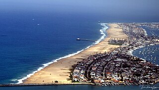
<span class="mw-page-title-main">Port of Los Angeles</span> Harbor in Los Angeles, California

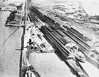
The Port of Los Angeles is a seaport managed by the Los Angeles Harbor Department, a unit of the City of Los Angeles. It occupies 7,500 acres (3,000 ha) of land and water with 43 miles (69 km) of waterfront and adjoins the separate Port of Long Beach. Promoted as "America's Port", the port is located in San Pedro Bay in the San Pedro and Wilmington neighborhoods of Los Angeles, approximately 20 miles (32 km) south of downtown.

The history of Santa Monica, California, covers the significant events and movements in Santa Monica's past.

The Free Harbor Fight refers to the legal battle in the late nineteenth century on the West Coast of the United States, around Los Angeles Area Chamber of Commerce against Huntington and the Southern Pacific. US Senator Stephen M. White failed to cave in to the pressure of the railroad baron Collis Huntington and his congressional allies, which resulted in the Port of Los Angeles being located in San Pedro, instead of Santa Monica, as Huntington had wanted.

<span class="mw-page-title-main">San Pedro Bay (California)</span> Bay near Los Angeles in California, United States

San Pedro Bay is an inlet on the Pacific Ocean coast of southern California, United States. It is the site of the Port of Los Angeles and the Port of Long Beach, which together form the fifth-busiest port facility in the world and the busiest in the Americas. The Los Angeles community of San Pedro borders a small portion of the western side of the bay. The city of Long Beach borders the port on the eastern side of the bay. The northern part of the bay, which is the largest part of the port, is bordered by the Los Angeles neighborhood of Wilmington.

<span class="mw-page-title-main">Pacific Electric Building</span> Historic building in Los Angeles, California

The historic Pacific Electric Building, opened in 1905 in the core of Los Angeles as the main train station for the Pacific Electric Railway, as well as the company's headquarters; Main Street Station served passengers boarding trains for the south and east of Southern California. The building was designed by architect Thornton Fitzhugh. Though not the tallest in Los Angeles, its ten floors enclosed the greatest number of square feet in any building west of Chicago for many decades. Above the train station, covering the lower floors, were five floors of offices; and in the top three was the Jonathan Club, one of the city's leading businessmen's clubs introduced by magnates from the Northeast. After the “Great Merger” of Pacific Electric into Southern Pacific Railroad in 1911, the PE Building became the home of Southern Pacific in Los Angeles. In 1925, a second electric rail hub, the Subway Terminal, was opened near Pershing Square to serve the north and west.

<span class="mw-page-title-main">Oakland Long Wharf</span> Former rail-ferry pier in California

The Oakland Long Wharf was an 11,000-foot railroad wharf and ferry pier along the east shore of San Francisco Bay located at the foot of Seventh Street in West Oakland. The Oakland Long Wharf was built, beginning 1868, by the Central Pacific Railroad on what was previously Oakland Point. Beginning November 8, 1869, it served as the west coast terminus of the First transcontinental railroad. In the 1880s, Southern Pacific Railroad took over the CPRR, extending it and creating a new ferry terminal building with the official station name Oakland Pier. The entire structure became commonly and popularly called the Oakland Mole. Portions of the Wharf lasted until the 1960s. The site is now part of the facilities of the Port of Oakland, while passenger train service operates at the nearby Jack London Square/Dellums Station and another nearby station in Emeryville.

<span class="mw-page-title-main">Pacific Coast Railway</span> Narrow-gauge railway in California, United States

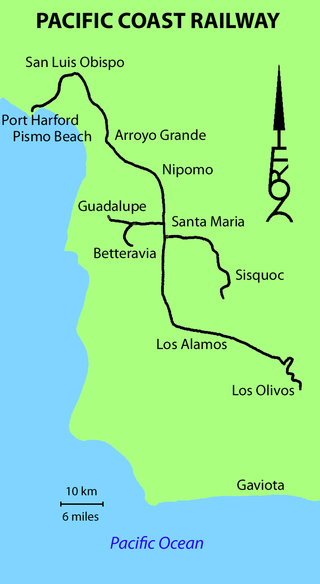
The Pacific Coast Railway was a 3 ft narrow gauge railway on the Central Coast of California. The original 10-mile (16 km) link from San Luis Obispo to Avila Beach and Port Harford was later built southward to Santa Maria and Los Olivos, with branches to Sisquoc and Guadalupe.

<span class="mw-page-title-main">Los Angeles and Independence Railroad</span> Former train service from Los Angeles to Santa Monica

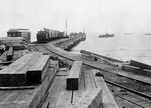
The Los Angeles and Independence Railroad, opened on October 17, 1875, was a steam-powered rail line which ran between the Santa Monica Long Wharf and 5th and San Pedro streets in downtown Los Angeles.

<span class="mw-page-title-main">Waterfront Red Car</span> California heritage railway (2003–2015)

The Port of Los Angeles Waterfront Red Car Line was a 1.5-mile (2.4 km) heritage streetcar line for public transit along the waterfront in San Pedro, at the Port of Los Angeles in Los Angeles, California. The line operated between July 2003 and September 2015, when service was discontinued due to major construction projects that resulted in the demolition of a portion of the route.

<span class="mw-page-title-main">Santa Monica Air Line</span> Former train service from Los Angeles to Santa Monica

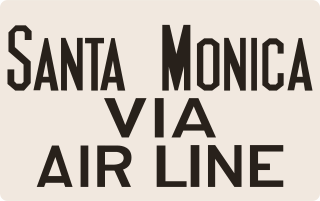
The Santa Monica Air Line was an interurban railroad operated by the Pacific Electric between Santa Monica and downtown Los Angeles. Electric passenger service operated over the line between 1908 and 1953. After abandonment as a freight railroad, most of the route was converted to light rail for use by the Metro E Line.

<span class="mw-page-title-main">Long Beach Line</span> Pacific Electric interurban route in California

The Long Beach Line was a major interurban railway operated by the Pacific Electric Railway between Los Angeles and Long Beach, California via Florence, Watts, and Compton. Service began in 1902 and lasted until 1961, the last line of the system to be replaced by buses.

Streetcars in Los Angeles over history have included horse-drawn streetcars and cable cars, and later extensive electric streetcar networks of the Los Angeles Railway and Pacific Electric Railway and their predecessors. Also included are modern light rail lines.

<span class="mw-page-title-main">California Central Railway</span> SoCal railroad system (1887-1889)

The California Central Railway was incorporated on April 23, 1887, with headquarters in San Bernardino, California. George O. Manchester was the President of the corporation.

<span class="mw-page-title-main">Los Angeles Pacific Railroad</span> California interurban and freight routes (1896–1911)

The Los Angeles Pacific Railroad (1896−1911) (LAP) was an electric public transit and freight railway system in Los Angeles County, California. At its peak it had 230 miles (370 km) of track extending from Downtown Los Angeles to the Westside, Santa Monica, and the South Bay towns along Santa Monica Bay.

<span class="mw-page-title-main">Port Ballona, California</span> 19th century planned harbor of Santa Monica Bay

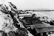
Port Ballona is an archaic place name for an area near the center of Santa Monica Bay in coastal Los Angeles County, where Playa Del Rey and Del Rey Lagoon are located today. Port Ballona was a planned harbor and town site from circa 1859 to 1903. The name comes from the Rancho La Ballona Mexican land grant.

<span class="mw-page-title-main">McFadden Wharf</span> California historic landmark

The place of McFadden Wharf was designated a California Historic Landmark (No.794) on July 3, 1964.

<span class="mw-page-title-main">Naval Base San Pedro</span> World War II Naval Base in Los Angeles

Naval Base San Pedro and San Pedro Submarine Base were United States Navy bases at the Port of San Pedro, California officially founded in 1919. While commissioned in 1919, the Navy started operating out of the port in 1910, by renting dock space at the City of San Pedro's Dock No. 1 in 1914. The Navy had vessels stationed at the port starting in 1913. The San Pedro Submarine Base closed in 1923, with the end of World War I. Naval Base San Pedro became part of Naval Operating Base Terminal Island on 25 September 1941, which closed in 1947.

References

  1. "Site of Port Los Angeles Long Wharf". Office of Historic Preservation, California State Parks. Retrieved 2014-08-05.
  2. "Southern Pacific Long Wharf, or Mile Long Pier, Pacific Palisades, ca.1893". USC Digital Library. USC. Retrieved 5 January 2015.
  3. "Santa Monica beach, including the long wharf, north of the canyon, 1912". USC Digital Library. Retrieved 5 January 2015.
  4. CA.GOV SITE OF PORT LOS ANGELES LONG WHARF, Historical Landmark
  5. abandonedrails.com, Santa Monica to Port Los Angeles
  6. United States. Board Appointed to Locate a Deep-Water Harbor at Port Los Angeles or at San Pedro, Calif; Russell Alexander Alger; John Grimes Walker (1897). Deep-water Harbor at Port Los Angeles Or at San Pedro, Cal: Letter of the Secretary of War, in Response to the Resolution of the Senate Dated March 3, 1897, Directing Him "to Transmit to the Senate the Report Made to Him by the Board Appointed ... Under the Provisions of the River and Harbor Act of June 3, 1896 : Together with the Plans, Specifications, and Estimates Made by Said Board" : Together with Accompanying Maps and Papers. Government, Print. Office.
  7. erha.org Santa Monica Canyon Line
  8. delreync.org, Del Rey Neighborhood Council, Marina Del Rey History Archived 2014-07-14 at the Wayback Machine
  9. erha.org Los Angeles Pacific Corporate Histories