Loomis, Michigan

Last updated

Loomis, Michigan
Loomis, Michigan.jpg
Intersection of Saginaw and Loomis Road
Loomis, MI location.png
Location within Isabella County
USA Michigan location map.svg
Red pog.svg
Loomis
Location within the state of Michigan
Usa edcp location map.svg
Red pog.svg
Loomis
Location within the United States
Coordinates: 43°47′36″N84°40′00″W / 43.79333°N 84.66667°W / 43.79333; -84.66667
CountryUnited States
State Michigan
County Isabella
Township Wise
Settled1871
Area
[1]
  Total2.82 sq mi (7.30 km2)
  Land2.80 sq mi (7.25 km2)
  Water0.02 sq mi (0.05 km2)
Elevation
[2]
805 ft (245 m)
Population
 (2020) [3]
  Total194
  Density69.29/sq mi (26.75/km2)
Time zone UTC-5 (Eastern (EST))
  Summer (DST) UTC-4 (EDT)
ZIP code(s)
48617 (Clare)
Area code 989
GNIS feature ID631028 [2]

Loomis is an unincorporated community and census-designated place (CDP) in Isabella County in the U.S. state of Michigan. [2] The population of the CDP was 194 at the 2020 census. [3] The community is located within Wise Township, and is also located within the Isabella Indian Reservation, home to the federally-recognized Saginaw Chippewa Tribal Nation.

Contents

History

The community was first settled as early as 1871 by Erastus Loomis, George Wise, and E. F. Gould, who built a sawmill and a general store. The same year, it received a train depot along the Flint and Pere Marquette Railroad and also received a post office under the name Buchtel on May 1, 1871. Wise served as the first postmaster. The post office was renamed to Loomis on December 8, 1871. When the area was organized as a new township on January 24, 1872, it was named Wise Township. [4] The community first appeared on an 1873 map of Isabella County, in which Wise Township then occupied two survey townships in the northeast portion of the county. [5]

Located about 16.0 miles (25.7 km) north of Mount Pleasant, the community grew quickly. In 1877, Loomis recorded a population of around 350 and included several sawmills, general stores, churches, and two hotels. During the height of the lumber and railroad industry, the area population may have been as high as 800. The railway served the community until about 1960 when the lines were removed. With the expansion of U.S. Route 10 in the early 1960s, the highway bypassed Loomis to the north, which prevented any direct traffic to the dwindling community. In 1970, Loomis may have had as few as 15 families, a gas station, the market, and the town hall. The oldest structure in the community is Patrick Holden's hotel, which was one of the original structures when the community was settled in 1871. The structure remains and is now a market and antique shop. [6]

At the 2010 census, Loomis was listed as a new census-designated place and recorded a population of 213. [7] The Loomis post office is no longer in operation, and the community is served by the Clare 48617 ZIP Code. [8] [9]

Geography

According to the U.S. Census Bureau, the Loomis CDP has a total area of 2.82 square miles (7.30 km2), of which 2.80 square miles (7.25 km2) is land and 0.02 square miles (0.05 km2) (0.71%) is water. [7]

U.S Route 10 passes through the community and is accessible via Loomis Road exit 98. The Pere Marquette Rail-Trail passes through the community along the former railway line. The community is also within the boundaries of the Isabella Indian Reservation.

The community is served by Clare Public Schools, which is located to the northwest in the city of Clare. [10]

Demographics

Historical population
CensusPop.Note
2010 213
2020 194−8.9%
U.S. Decennial Census [11]

Related Research Articles

<span class="mw-page-title-main">Garfield Township, Clare County, Michigan</span> Civil township in Michigan, United States

Garfield Township is a civil township of Clare County in the U.S. state of Michigan. The population was 1,807 at the 2020 census.

<span class="mw-page-title-main">Vernon Township, Isabella County, Michigan</span> Civil township in Michigan, United States

Vernon Township is a civil township of Isabella County in the U.S. state of Michigan. The population was 1,342 based on the 2000 census.

<span class="mw-page-title-main">Wise Township, Michigan</span> Civil township in Michigan, United States

Wise Township is a civil township of Isabella County in the U.S. state of Michigan. The population was 1,355 at the 2020 census.

Chase Township is a civil township of Lake County in the U.S. state of Michigan. The population was 1,194 at the 2000 census.

Sweetwater Township is a civil township of Lake County in the U.S. state of Michigan. The population was 238 at the 2000 census.

<span class="mw-page-title-main">Big Bay, Michigan</span> Census-designated place & unincorporated community in Michigan, United States

Big Bay is an unincorporated community in Marquette County of the U.S. state of Michigan. It is a census-designated place (CDP) for statistical purposes and does not have any legal status as an incorporated municipality. As of the 2020 census, the CDP had a population of 257, down from 319 in 2010. The community is located within Powell Township near the shore of Big Bay on Lake Superior.

<span class="mw-page-title-main">Michigamme, Michigan</span> Census-designated place & unincorporated community in Michigan, United States

Michigamme is an unincorporated community in Marquette County in the U.S. state of Michigan. It is located within Michigamme Township on the north shores of Lake Michigamme. For statistical purposes, the United States Census Bureau has defined Michigamme as a census-designated place (CDP). The CDP had a population of 255 at the 2020 census.

<span class="mw-page-title-main">Palmer, Michigan</span> Census-designated place & unincorporated community in Michigan, United States

Palmer is an unincorporated community in Marquette County in the U.S. state of Michigan. It is a census-designated place (CDP) for statistical purposes and has no legal status as an incorporated municipality. The CDP had a population of 378 at the 2020 census. It is located within Richmond Township along M-35.

<span class="mw-page-title-main">Republic, Michigan</span> Census-designated place & unincorporated community in Michigan, United States

Republic is an unincorporated community in Marquette County in the U.S. state of Michigan. It is also a census-designated place (CDP) for statistical purposes and no legal status as an incorporated municipality. The CDP had a population of 470 at the 2020 census, down from 570 in 2010. The community is located mostly within Republic Township with a small portion extending north into Humboldt Township.

Orient Township is a civil township of Osceola County in the U.S. state of Michigan. The population was 803 at the 2000 census.

<span class="mw-page-title-main">Freeland, Michigan</span> Census-designated place & unincorporated community in Michigan, United States

Freeland is a census-designated place in Tittabawassee Township, Saginaw County in the U.S. state of Michigan. It is part of the Saginaw-Midland-Bay Metropolitan Area. As of the 2000 census, the CDP population was 5,147. The CDP covers an area in the central portion of Tittabawassee Township. The Freeland post office, ZIP code 48623, serves nearly the entire township, as well as portions of Midland and Williams townships to the north, Frankenlust and Kochville townships to the east, Thomas and Richland townships to the south, and Ingersoll Township to the west.

Watertown Township is a civil township of Tuscola County in the U.S. state of Michigan. The population was 2,202 at the 2010 Census.

<span class="mw-page-title-main">Kenockee Township, Michigan</span> Civil township in Michigan, United States

Kenockee Township is a civil township of St. Clair County in the U.S. state of Michigan. The population was 2,470 at the 2010 Census.

<span class="mw-page-title-main">Attica, Michigan</span> Census-designated place & unincorporated community in Michigan, United States

Attica is an unincorporated community and census-designated place in Attica Township, Lapeer County, Michigan, United States. Its population was 994 as of the 2010 census. Attica has a post office with ZIP code 48412.

<span class="mw-page-title-main">Bay Port, Michigan</span> Census-designated place & unincorporated community in Michigan, United States

Bay Port is an unincorporated community and census-designated place (CDP) in Huron County in the U.S. state of Michigan. The population was 477 at the 2010 census. As an unincorporated community, Bay Port has no legal autonomy of its own but does have its own post office with the 48720 ZIP Code.

<span class="mw-page-title-main">Brethren, Michigan</span> Census-designated place in Michigan, United States

Brethren is an unincorporated community and census-designated place (CDP) in the U.S. state of Michigan. The community is located within Dickson Township, Manistee County, and is in the Northern Lower Peninsula of Michigan. The community had a population of 331 at the 2020 census, down from 410 in 2010. The community is located in the Manistee National Forest, 18 miles (29 km) northeast of Manistee. Brethren has a post office with ZIP code 49619.

<span class="mw-page-title-main">Riverdale, Michigan</span> Census-designated place & unincorporated community in Michigan, United States

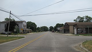
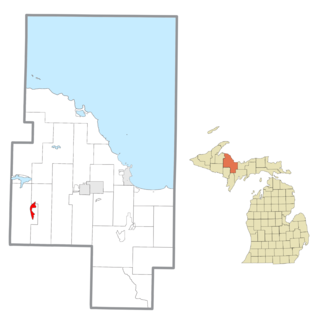
Riverdale is an unincorporated community and census-designated place (CDP) in Gratiot County in the U.S. state of Michigan. The population of the CDP was 281 at the 2020 census. The community is located within Seville Township.

<span class="mw-page-title-main">Winn, Michigan</span> Census-designated place & unincorporated community in Michigan, United States

Winn is an unincorporated community and census-designated place (CDP) in Isabella County in the U.S. state of Michigan. The CDP had a population of 166 at the 2020 census. The community is located within Fremont Township.

<span class="mw-page-title-main">Lake, Clare County, Michigan</span> Unincorporated community in Michigan, United States

Lake is an unincorporated community in Clare County in the U.S. state of Michigan. The community is located within Garfield Township. As an unincorporated community, Lake has no legal autonomy of its own but does have its own post office with the 48632 ZIP Code.

Stronach is an unincorporated community and census-designated place (CDP) in Stronach Township, Manistee County, Michigan, United States. Its population was 170 as of the 2020 census. The community is located at the southeast end of Manistee Lake.

References

  1. "2020 U.S. Gazetteer Files". United States Census Bureau. Retrieved May 21, 2022.
  2. 1 2 3 U.S. Geological Survey Geographic Names Information System: Loomis, Michigan
  3. 1 2 United States Census Bureau (June 14, 2023). "Loomis CDP; Michigan".
  4. Romig, Walter (October 1, 1986) [1973]. Michigan Place Names: The History of the Founding and the Naming of More Than Five Thousand Past and Present Michigan Communities (Paperback). Detroit, Michigan: Wayne State University Press. pp. 334–335. ISBN   978-0-8143-1838-6.
  5. Cartography Associates (2023). "Map of Isabella County, Michigan (1873)" . Retrieved June 23, 2023.
  6. Ray, Dodge (1990) [1970, 1971]. Michigan Ghost Towns: Of the Lower Peninsula (formerly Michigan Ghost Towns I & II). Alpena, Michigan: Thunder Bay Press Michigan. p. 108. ISBN   0-932-21264-6.
  7. 1 2 "Michigan: 2010 Population and Housing Unit Counts 2010 Census of Population and Housing" (PDF). 2010 United States census . United States Census Bureau. September 2012. pp. III-6, 26 Michigan. Archived (PDF) from the original on October 19, 2012. Retrieved January 13, 2023.
  8. Google (June 14, 2023). "48617 ZIP Code map" (Map). Google Maps . Google. Retrieved June 14, 2023.
  9. UnitedStatesZipCodes.org (2023). "ZIP Code 48617: Clare" . Retrieved June 14, 2023.
  10. Michigan Geographic Framework (November 15, 2013). "Isabella County School Districts" (PDF). Retrieved August 28, 2022.
  11. "Census of Population and Housing". Census.gov. Retrieved June 4, 2016.