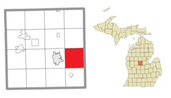
Chippewa Township, Michigan | |
---|---|
Coordinates: 43°35′52″N84°40′26″W / 43.59778°N 84.67389°W | |
Country | United States |
State | Michigan |
County | Isabella |
Area | |
• Total | 36.3 sq mi (94.0 km2) |
• Land | 36.2 sq mi (93.7 km2) |
• Water | 0.1 sq mi (0.3 km2) |
Elevation | 745 ft (227 m) |
Population (2000) | |
• Total | 4,617 |
• Density | 127.6/sq mi (49.3/km2) |
Time zone | UTC-5 (Eastern (EST)) |
• Summer (DST) | UTC-4 (EDT) |
ZIP code(s) | 48858, 48883 |
Area code | 989 |
FIPS code | 26-15580 [1] |
GNIS feature ID | 1626079 [2] |
Chippewa Township is a civil township of Isabella County in the U.S. state of Michigan. As of the 2000 census, the township population was 4,617. The city of Mount Pleasant is nearby to the west, and the Mount Pleasant post office, with ZIP code 48858, also serves the northern portion of Chippewa Township. [3]
There are no incorporated municipalities within the township.
As of the census [1] of 2000, there were 4,617 people, 1,653 households, and 1,203 families residing in the township. The population density was 127.6 inhabitants per square mile (49.3/km2). There were 1,744 housing units at an average density of 48.2 per square mile (18.6/km2). The racial makeup of the township was 80.49% White, 0.61% African American, 14.81% Native American, 0.26% Asian, 0.11% Pacific Islander, 0.52% from other races, and 3.21% from two or more races. Hispanic or Latino of any race were 3.16% of the population.
There were 1,653 households, out of which 38.1% had children under the age of 18 living with them, 53.2% were married couples living together, 14.5% had a female householder with no husband present, and 27.2% were non-families. 20.4% of all households were made up of individuals, and 4.5% had someone living alone who was 65 years of age or older. The average household size was 2.78 and the average family size was 3.20.
In the township the population was spread out, with 29.9% under the age of 18, 10.2% from 18 to 24, 31.3% from 25 to 44, 21.1% from 45 to 64, and 7.5% who were 65 years of age or older. The median age was 32 years. For every 100 females, there were 100.5 males. For every 100 females age 18 and over, there were 98.5 males.
The median income for a household in the township was $35,676, and the median income for a family was $43,804. Males had a median income of $31,467 versus $24,344 for females. The per capita income for the township was $16,312. About 9.8% of families and 13.9% of the population were below the poverty line, including 14.6% of those under age 18 and 9.7% of those age 65 or over.
Isabella County is a county located in the U.S. state of Michigan. As of the 2020 Census, the population was 64,394. Its county seat is Mount Pleasant. The area was known as Ojibiway Besse, meaning "the place of the Ojibwa". Isabelle County contains the Isabella Indian Reservation, on which members of the Saginaw Chippewa Tribal Nation live.
Baltimore Township is a civil township of Barry County in the U.S. state of Michigan. As of the 2010 census, the township population was 1,861. Baltimore Township was established in 1849.
Clarence Township is a civil township located in northeast Calhoun County in the U.S. state of Michigan. It is part of the Battle Creek, Michigan Metropolitan Statistical Area. The population was 1,985 at the 2010 census. The township was originally named Pinkney Township.
Clarendon Township is a civil township of Calhoun County in the U.S. state of Michigan. The population was 1,139 at the 2010 census. The township is part of the Battle Creek Metropolitan Statistical Area.
Pickford Township is a civil township of Chippewa County in the U.S. state of Michigan. As of the 2010 census, the township population was 1,595.
Raber Township is a civil township of Chippewa County in the U.S. state of Michigan. The population was 647 at the 2010 census.
Coe Township is a civil township of Isabella County in the U.S. state of Michigan. The population was 2,993 at the 2000 census.
Isabella Township is a civil township of Isabella County in the U.S. state of Michigan. The population was 2,096 at the 2020 census.
Burnside Township is a civil township of Lapeer County in the U.S. state of Michigan. The population was 1,864 at the 2010 Census.
Lapeer Township is a civil township of Lapeer County in the U.S. state of Michigan. The population was 5,056 at the 2010 Census. The name is an Americanization of the French La pierre, which means "flint" or "flint stone".
Tallmadge Charter Township is a charter township of Ottawa County in the U.S. state of Michigan. The population was 7,575 at the 2010 census.
Brant Township is a civil township of Saginaw County in the U.S. state of Michigan. As of the 2010 Census, the township population was 2,012.
Delaware Township is a civil township of Sanilac County in the U.S. state of Michigan. The population was 784 at the 2020 census.
Elk Township is a civil township of Sanilac County in the U.S. state of Michigan. The population was 1,522 at the 2020 census.
Watertown Township is a civil township of Sanilac County in the U.S. state of Michigan. The population was 1,376 at the 2000 census.
Gilford Township is a civil township of Tuscola County in the U.S. state of Michigan. The population was 741 at the 2010 Census.
Watertown Township is a civil township of Tuscola County in the U.S. state of Michigan. The population was 2,202 at the 2010 Census.
Brookfield Township is a civil township of Eaton County in the U.S. state of Michigan. As of the 2010 census, the township population was 1,537.
Franklin Township is a civil township of Lenawee County in the U.S. state of Michigan. The population was 2,939 at the 2000 census.
Richland Township is a civil township of Montcalm County in the U.S. state of Michigan. The population was 2,646 at the 2020 census, down from 2,778 in 2010.