Interstate 57 (I-57) is an Interstate Highway in Missouri and Illinois that parallels the old Illinois Central rail line for much of its route. It runs from Sikeston, Missouri, at Interstate 55 to Chicago, Illinois, at Interstate 94. I-57 essentially serves as a shortcut route for travelers headed between the south and Chicago, bypassing St. Louis, Missouri. Between the junction of I-55 and I-57 in Sikeston, Missouri and the junction of I-55 and I-90/94 in Chicago, I-55 travels for 436 miles (702 km), while the combination of I-57 and I-94 is only 396 miles (637 km) long between the same two points. In fact, both the control cities on the overhead signs, as well as destination mileage signs, reference Memphis, Tennessee along southbound I-57, even as far north as its northern origin at I-94 in Chicago. Likewise, at its southern end, Chicago is the control city listed for I-57 on signs on northbound I-55 south of Sikeston, Missouri, even though I-55 also goes to Chicago.
Illinois Route 50 (IL 50) is a 66.49-mile-long (107.01 km) north–south state road in northeastern Illinois. It runs from the junction with U.S. Route 45 (US 45) in West Kankakee north to US 41 in Skokie. In Chicago and the suburbs it's known as Cicero Avenue. Before this, Cicero Avenue was previously known as 48th Avenue, owing to its City of Chicago address of 4800 West.
Illinois Route 23 is a north–south state highway in northern Illinois. It runs from Illinois Route 116 in Pontiac north to U.S. Route 14 south of Harvard. This is a distance of 122.77 miles (197.58 km).
Illinois Route 1 (IL 1) is a state highway in the U.S. state of Illinois. Running parallel to the Indiana border, it is also the longest state road, starting at the free ferry crossing to Kentucky at Cave-in-Rock on the Ohio River and running north to the south side of Chicago as Halsted Street at an intersection with Interstate 57. This is a distance of 325.59 miles (523.99 km).
The St. Charles Air Line is a rail line in Chicago, Illinois, partially owned by the BNSF Railway, Union Pacific Railroad, and Canadian National Railway.

The Chicago and Western Indiana Railroad was the owner of Dearborn Station in Chicago and the trackage leading to it. It was owned equally by five of the railroads using it to reach the terminal, and kept those companies from needing their own lines into the city. With the closure of Dearborn Station in 1971 and the Calumet steel mills in 1985, the railroad was gradually downgraded until 1994 when it became a subsidiary of the Union Pacific Corporation.

A level junction is a railway junction that has a track configuration in which merging or crossing railroad lines provide track connections with each other that require trains to cross over in front of opposing traffic at grade.
The Keokuk Junction Railway Co., is a Class III railroad in the U.S. states of Illinois and Iowa. It is a subsidiary of Pioneer Railcorp.
Illinois Route 41 is a north–south highway in rural west-central Illinois. It runs from U.S. Route 136 near Macomb north to U.S. Route 34 and Illinois Route 164 in Galesburg, a distance of 37.53 miles (60.40 km). Illinois 41 is maintained by the Illinois Department of Transportation.
The Terminal Railroad Association of St. Louis is a switching and terminal railroad that handles traffic in the St. Louis, Missouri, metropolitan area. It is co-owned by several Class I railroads that reach the city.

Rondout is an unincorporated community in Lake County, Illinois, United States that first formed around a railroad junction. The area is located within Libertyville Township. As Rondout is an unincorporated community rather than a municipality, it lacks clearly defined borders, and shares postal codes with Lake Bluff, Lake Forest and Libertyville, Illinois. It has its own elementary school which comes under Rondout School District 72. Illinois Route 176 passes east–west through Rondout, serving as the "main street" of the community, where it is also called "Rockland Road".

U.S. Route 395 (US 395) is a United States Numbered Highway, stretching from Hesperia, California to the Canadian border in Laurier, Washington. The California portion of US 395 is a 557-mile (896 km) route which traverses from Interstate 15 in Hesperia, north to the Oregon state line in Modoc County near Goose Lake. The route clips into Nevada, serving the cities Carson City and Reno, before returning to California.

75th Street is an electrified commuter rail station along the Metra Electric Main Line in the Greater Grand Crossing neighborhood of the City of Chicago, Illinois. It is located at and over both 75th Street and South Chicago Avenue, and is 9.32 miles (15.00 km) away from the northern terminus at Millennium Station. In Metra's zone-based fare system, Grand Crossing is in zone B.

Hartland, elevation 922 feet, is an unincorporated community in McHenry County, Illinois, United States.

The Central Corridor is a rail line operated by the Union Pacific Railroad from near Winnemucca, Nevada to Denver, Colorado in the western United States. The line was created after the merger with the Southern Pacific Transportation Company by combining portions of lines built by former competitors. No portion of the line was originally built by the Union Pacific; in fact, some portions were built specifically to compete with the Union Pacific's Overland Route. The line is known for significant feats of engineering while crossing the Wasatch Mountains of Utah and the Rocky Mountains of Colorado. The line features numerous tunnels, the longest and highest of these is the Moffat Tunnel.

The Kenwood branch was a rapid transit line which was part of the Chicago 'L' system from 1907 to 1957. The branch served the Kenwood neighborhood of Chicago and consisted of six elevated stations. It opened on September 20, 1907 and closed on December 1, 1957.
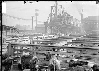
The Stock Yards branch was a rapid transit line which was part of the Chicago 'L' system from 1908 to 1957. The branch served the Union Stock Yards and the Canaryville neighborhood of Chicago and consisted of eight elevated stations. It opened on April 8, 1908, and closed on October 6, 1957.

Browns Mills Junction is an unincorporated community located within Pemberton Township in Burlington County, New Jersey, United States. The site, located about 1.6 miles (2.6 km) southwest of downtown Browns Mills, is located at the crossing of Junction Road and the Philadelphia and Long Branch Railway, later a part of the Pennsylvania Railroad. It was the site of a train station named Browns Mills in-the-Pines where a short branch connected the main line to Browns Mills. The settlement features a few houses along Junction Road and Mount Misery Road but is otherwise very forested as a part of the New Jersey Pine Barrens.

The California Zephyr is a passenger train operated by Amtrak between Chicago and the San Francisco Bay Area, via Omaha, Denver, Salt Lake City, and Reno. At 2,438 miles (3,924 km), it is Amtrak's longest daily route, and second-longest overall after the Texas Eagle's triweekly continuation from San Antonio to Los Angeles, with travel time between the termini taking approximately 511⁄2 hours. Amtrak claims the route as one of its most scenic, with views of the upper Colorado River valley in the Rocky Mountains, and the Sierra Nevada. The modern train is the second iteration of a train named California Zephyr; the original train was privately operated and ran on a different route through Nevada and California.


