Loring Hall

Last updated

Loring Hall
Loring Hall, North Cray (Southeast View - 01).jpg
Loring Hall
Bexley London UK location map.svg
Red pog.svg
Location within Bexley
Geography
Location North Cray, London, England
Coordinates 51°25′51″N0°8′22″E / 51.43083°N 0.13944°E / 51.43083; 0.13944
Organisation
Type Specialist
Services
Emergency department No
SpecialityPsychiatry
Helipad No
History
Opened2004

Loring Hall is a private mental health care facility in North Cray, London Borough of Bexley. Formerly known as Wollet Hall or Woollet Hall, it is a Grade II listed building. [1]

Contents

History

Blue plaque Blue Plaque for the Viscount Castlereagh.jpg
Blue plaque

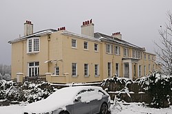
The present building was constructed in 1760 on the site of an earlier Tudor house known as "Waletts". [2] Its owner in this period was Neighbour Frith, Esq, a London silk merchant. Frith was the last member of a family who had held land in North Cray for many years: his father, John, and grandfather, Roger, are buried at nearby North Cray parish church. [3]

In 1776 Frith willed Woollet Hall to his nephew, the Rev. Edward Cockayn, who adopted the surname Frith. [4] Cockayn subsequently leased the house to a Mr Trimmer, probably Joshua Kirby Trimmer of Bexleyheath, whose son, the geologist Joshua Trimmer, was born at North Cray. [5]

From 1811 the house was the country residence of British Foreign Secretary, Viscount Castlereagh, later Marquess of Londonderry. In 1822 Castlereagh, after suffering a possible nervous breakdown, committed suicide there by cutting his own throat, aged 53. His residence at the house is still commemorated by a blue plaque installed by English Heritage. [6]

Subsequent to Castlereagh's ownership the house was owned by a banker, Richard Gosling. [7] The Gosling family did not use the name Woollet Hall during their time there. [8] By the 1850s the Hall had been purchased by Frederick Friend, whose family occupied it until the late 19th century. [9]

The west face of Loring Hall, from Foots Cray Meadows. Loring Hall (geograph 2841743).jpg
The west face of Loring Hall, from Foots Cray Meadows.

In 1939 the building and grounds were purchased by Goldsmiths College and Woollet Hall was renamed Loring Hall after the first warden of Goldsmiths College, Captain William Loring, who was killed at Gallipoli during the First World War. The main part of the hall was used as a hall of residence for male students and the stable block and associated house were used as an accommodation for a Head of Hall. The grounds became football, hockey and cricket fields for use by the students of Goldsmiths. [10]

Goldsmiths College sold the hall and grounds to Bupa sometime in the 1980s, who converted it into a care home. In 1999 it was bought by the charity Sargent Cancer Care for Children and was renamed Malcolm Sargent House. [11]

In 2003 it was sold again to a company called Oakfields Care and since March 2004 it has been a care facility for those with learning disabilities. [12]

See also

Related Research Articles

<span class="mw-page-title-main">Crayford</span> Human settlement in England

Crayford is a town and electoral ward in South East London, England, within the London Borough of Bexley. It lies east of Bexleyheath and north west of Dartford. Crayford was in the historic county of Kent until 1965. The settlement developed by the river Cray, around a ford that is no longer used.

<span class="mw-page-title-main">Sidcup</span> Human settlement in England

Sidcup is an area of south-east London, England, primarily in the London Borough of Bexley. It is 11.3 miles (18.2 km) south-east of Charing Cross, bordering the London Boroughs of Bromley and Greenwich. Before the creation of Greater London in 1965, it was in the historical county of Kent.

<span class="mw-page-title-main">London Borough of Bexley</span> Borough in United Kingdom

The London Borough of Bexley is a London borough in south-east London, forming part of Outer London. It has a population of 248,287. The main settlements are Sidcup, Erith, Bexleyheath, Crayford, Welling and Old Bexley. The London Borough of Bexley is within the Thames Gateway, an area designated as a national priority for urban regeneration. The local authority is Bexley London Borough Council.

<span class="mw-page-title-main">Bexley</span> Human settlement in England

Bexley is an area of south-eastern Greater London, England and part of the London Borough of Bexley. It is sometimes known as Bexley Village or Old Bexley to differentiate the area from the wider borough. It is located 13 miles (21 km) east-southeast of Charing Cross and south of Bexleyheath.

<span class="mw-page-title-main">Nicholas Vansittart, 1st Baron Bexley</span> British politician

Nicholas Vansittart, 1st Baron Bexley, was an English politician, and one of the longest-serving Chancellors of the Exchequer in British history.

<span class="mw-page-title-main">Foots Cray</span> Human settlement in England

Foots Cray is an area of South East London, England, within the London Borough of Bexley. Prior to 1965 it was in the historic county of Kent. It is located south-east of Sidcup, north of Orpington and north west of Swanley.

<span class="mw-page-title-main">River Cray</span> River

The River Cray is the largest tributary of the Darent. It is the prime river of outer, south-east Greater London, rising in Priory Gardens, Orpington, where rainwater percolates through the chalk bedrock of the Downs to form a pond where the eroded ground elevation gives way to impermeable clay. Initially it flows true to form northwards, past industrial and residential St Mary Cray, through St Paul's Cray and through Foots Cray, where it enters the parkland Foots Cray Meadows, flowing under by Five Arches bridge. It then flows by restored Loring Hall (c.1760), home of the Lord Castlereagh who killed himself there in 1822. It continues through North Cray and Bexley. It neighbours a restored Gothic (architecture) cold plunge bath house, built around 1766 as part of Vale Mascal Estate. It is then joined by the River Shuttle and then continues through the parkland of Hall Place, which was built for John Champneys in 1540. The Cray turns eastward through Crayford and Barnes Cray to join the Darent in Dartford Creek. The Creek is a well-watered partly tidal inlet between Crayford Marshes and Dartford Marshes by a slight projection of land, Crayford Ness. The villages through which the Cray flows are collectively known as "The Crays".

<span class="mw-page-title-main">West Malling</span> Human settlement in England

West Malling is a market town in the Tonbridge and Malling district of Kent, England. It has a population of 2,590.

<span class="mw-page-title-main">Danson Park</span> Historic site

Danson Park is a public park in the London Borough of Bexley, South East London, located between Welling and Bexleyheath. At 75 hectares, it is the second largest public park in the borough, and the most used by the community. Opened in 1925, it is often considered the finest green open space in the borough, and is Grade II listed on the Register of Historic Parks and Gardens. The park also gives its name to the electoral ward that covers the park and the surrounding area. The park is located at grid reference TQ472752. The southern boundary of both the park and the ward is delineated by Rochester Way, the A2 road.

<span class="mw-page-title-main">Hall Place</span>

Hall Place is a stately home in the London Borough of Bexley in south-east London, built in 1537 for Sir John Champneys, a wealthy merchant and former Lord Mayor of London. The house was extended in 1649 by Sir Robert Austen, a merchant from Tenterden in Kent. The house is a Grade I listed building and Scheduled Ancient Monument, and surrounded by a 65-hectare award-winning garden. It is situated on the A223, Bourne Road, south of Watling Street (A207) and north of the Black Prince interchange of the A2 dual carriageway and two lesser roads.

<span class="mw-page-title-main">Wilmington, Kent</span> Human settlement in England

Wilmington is a village and civil parish in the Borough of Dartford in Kent, England. It is located 2.7 miles south of Dartford, 3.5 miles north of Swanley and 4.3 miles south east of Bexleyheath, adjacent to the Kent border with Greater London.

<span class="mw-page-title-main">Albany Park, Bexley</span> Human settlement in England

Albany Park is an area in south east London, England, within the London Borough of Bexley. It is located 12.0 miles (19 km) south east of Charing Cross. Located midway between Sidcup and Bexley, Albany Park is situated on high ground overlooking the valleys of the River Cray and the River Shuttle.

<span class="mw-page-title-main">Joyden's Wood</span>

Joyden's Wood is an area of ancient woodland that straddles the border between the London Borough of Bexley in South East London and the Borough of Dartford in Kent, England. It is located 2.7 miles (4.3 km) north west of Swanley, 3.3 miles (5.3 km) south east of Bexleyheath and 3.6 miles (5.8 km) south west of Dartford. It is one of over 1,000 woodlands in the United Kingdom looked after by the Woodland Trust. The first records of a wood on this site go back to the year 1600. It is also the name of a housing estate to the east of the woodland itself.

<span class="mw-page-title-main">Amelia Stewart, Viscountess Castlereagh</span>

Amelia Anne Stewart, Marchioness of Londonderry, nicknamed "Emily" and, from 1794 until 1821 generally known as Lady Castlereagh, was the wife of the Georgian-era Anglo-Irish statesman Robert Stewart, Viscount Castlereagh, who from 1812 to 1822 was British Foreign Secretary and Leader of the House of Commons. Well-connected by birth to the aristocracy and wife of a prominent politician who was Britain's leading diplomat during the close of the Napoleonic Wars, Lady Castlereagh was an influential member of Regency London's high society.

Ruxley is a rural settlement of South East London, England that straddles the boundary of the London Boroughs of Bromley and Bexley. It is located 13 miles southeast of Charing Cross, the traditional centre of London, in the Metropolitan Green Belt between Sidcup and Swanley and is also adjacent to the Greater London border with the county of Kent.

<span class="mw-page-title-main">Hundred of Ruxley</span> Land division in Kent, England

Ruxley was an ancient hundred, a land division in the north west of the county of Kent, England. Its area has been mostly absorbed by the growth of London; with its name currently referring to the Ruxley district. Its former area now corresponds to a majority of the London Borough of Bromley, a large part of the London Borough of Bexley and a small part of the Kent District of Sevenoaks. The hundred was within the Lathe of Sutton-at-Hone, in the west division of Kent.

<span class="mw-page-title-main">North Cray</span> Human settlement in England

North Cray is a rural settlement in South East London, England, within the London Borough of Bexley. It is located east of Sidcup and south of Bexleyheath and is 12.6 miles (20.3 km) south-east of Charing Cross, the traditional centre of London in the Metropolitan Green Belt.

<span class="mw-page-title-main">Foots Cray Place</span>

Foots Cray Place was one of the four country houses built in England in the 18th century to a design inspired by Palladio's Villa Capra near Vicenza. Built in 1754 near Sidcup, Kent, Foots Cray Place was demolished in 1950 after a fire in 1949. Of the three other houses in England, Nuthall Temple in Nottinghamshire was built 1757 and demolished in 1929; the other two survive: Mereworth Castle and Chiswick House, both now Grade I listed buildings. A modern fifth example, Henbury Hall, was built near Macclesfield in the 1980s. Another example of a similar structure in England is the Temple of the Four Winds at Castle Howard, which is a garden building not a house.

<span class="mw-page-title-main">St Botolph's Church, Ruxley</span> Church in London Borough of Bromley, United Kingdom

St Botolph's Church is a church building in Ruxley, in the London Borough of Bromley, southeast London, England. It was constructed in the thirteenth century and dedicted to Botwulf of Thorney. St Botolph's was used as a church for around 300 years but was deconsecrated in 1557. The church was then used a farm building for over 400 years and the remains of an oast house are still adjacent to it. In the 1960s archaeological work was carried out on the site and found evidence of an older wooden building, suggesting there may have been an older Saxon church in the same location. Today the church is a Grade II listed building and a scheduled ancient monument on the grounds of Ruxley Manor Garden Centre, although many features are still intact, the church is in disrepair and English Heritage have agreed to pay a grant to help preserve the building.

References

  1. "Loring Hall, Greater London". britishlistedbuildings.co.uk. Retrieved 11 November 2013.
  2. Origin of place names in Bexley Archived 2013-12-22 at the Wayback Machine , Bexley Council
  3. North Cray Monumental Inscriptions, Kent Archaeological Society
  4. Hasted, Edward. The History and Topographic Survey of the County of Kent, v2, 1797, p.142
  5. Wikisource-logo.svg This article incorporates text from a publication now in the public domain :  Chisholm, Hugh, ed. (1911). "Trimmer, Joshua". Encyclopædia Britannica . Vol. 27 (11th ed.). Cambridge University Press.
  6. "Stewart, Robert, Viscount Castlereagh". English Heriitage. Retrieved 2 November 2011.
  7. Norman, Philip. Scores and Annals of the West Kent Cricket Club, 1897, p.6, p.85
  8. Norman, p.95
  9. "Loring Hall (previously known as Woollett Hall), North Cray - its early history". North Cray Residents Association. Retrieved 22 November 2021.
  10. "Loring Hall". Goldsmiths. Retrieved 2 November 2018.
  11. "Building is to become care home". News Shopper. 11 November 2003. Retrieved 2 November 2018.
  12. "Loring Hall Care Home" . Retrieved 2 November 2018.

Commons-logo.svg Media related to Loring Hall at Wikimedia Commons