The Warsaw Babice Airport was built between 1946 and 1950. Originally used by the military, it was scaled down at the end of the 1980s, with one of its two runways being removed, and eventually opened for civilian use in 1991.
Toponomy
The name Lotnisko translates in Polish to airfield, and refers to the Warsaw Babice Airport, which covers most of the neighbourhood area.[1]
History
Historically, the eastern area of the modern neighbourhood of Lotnisko was spanned by dunes, located between modern Boernerowo and Piaski. In 1655, during the Second Northern War, they were crossed by several Polish–Lithuanian infantry companies led by Janusz Radziwiłł. To commemorate the event, as the conflict was fought against Sweden, the dunes became known as the Swedish Mountains (Polish: Góry Szwedzkie).[2]
In 1794, during the Kościuszko Uprising, the combined Prussian and Russian forces took up positions on the hills to besiege the nearby city of Warsaw, with their artillery cannons. They were attacked by Polish forces, led by Józef Poniatowski, which managed to briefly occupy the dunes, before being pushed back. They were again captured in an attack led by Jan Henryk Dąbrowski. Another skirmish took place at the Swedish Mountains in 1831 during the November Uprising, when Polish–Lithuanian insurgents, following heavy fighting, were pushed out by the Russian forces, led by Ivan Paskevich.[2]
In 1916, a dirt runway aerodrome was built in the area, for the German Air Combat Forces.[1] In 1919, it was adapted by the Polish government for the use of the Aviation Institute of Technology, a government reaserch institution of aviation technologies.[4] It operated until 1939, and its institutions were inherited in 1953 by the Air Forse Institute of Technology, with majority of its laboratories now located within the nearby neighbourhood of Fort Bema, in the complex centred around 6 Księcia Bolesława Street.[5][6]
On 6 January 1940, while Warsaw was under the German occupation during the Second World War, the officers had executed and buried 96 people at the Swedish Mountains. It was one of the earliest mass executions committed in Poland during the conflict. The identity of the victims remains unknown. The bodies were exhumed in 1947.[9][10] In 2021, the event was commemorated with a memorial placed at the corner of Krasnodębskiego and Powstańców Śląskich Streets.[11]
On 2 August 1944, a resistance company unit of around 100 soldiers, led by Jerzy Terczyński, cryptonym Straż (Guard), was attacked by the German soldiers to the north of Boernerowo, within the area of the modern neighbourhood. The unit was retreating from Żoliborz and Bielany, while being separated and without means of communication with the rest of the insurgent forces. Polish soldiers, while in an open field, were ambushed and surrounded by German forces and shot at with machine guns. Additionally, they were shot at and rammed by a German tank. Over 70 resistance soldiers were killed, with a small number managing to escape, and a few being captured and executed afterwards. The German side suffered a few casualties and injuries.[12][13][14]
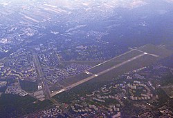
Between 1946 and 1950, the Warsaw Babice Airport was built in the area, with two concrete crossing runways. It was the first airfield in Poland designed for the jet aircraft. It was constructed mostly with the labour of around 2,000 German prisoners of war. After 1948, they were replaced with members of the paramilitary youth organisation Service of Poland.[1][15] Its location included the former aerodrome and the Swedish Mountains, which were flattened in 1949.[16] It took on the role of numerous smaller aerodromes around the city, which were closed down following its opening. The airport was owned and used by the military. Its existence and purpose remained classified from the public until 1957. At its peak, the airport had seven hangars and three air traffic control towers. On 24 July 1956, the Tupolev Tu-104 landed on the airfield, becoming the first civilian jet aircraft in the country. On 19 October 1956, Nikita Khrushchev, the General Secretary of the Communist Party of the Soviet Union, arrived at the airport during his visit to Poland. It was connected with the appointment of Władysław Gomułka as the First Secretary of the Polish United Workers' Party, and the following political crisis between both countries. In the following years, the airport was also visited by Richard Nixon, the Vice President of the United States, in 1972, and Charles de Gaulle, the President of France, in 1967.[1][15]
Throughout the 1970s and the 1980s, the area around the airport was developed with housing estates of apartment buildings. As such, at the end of the 1980s, it was decided to scale down the airfield. Its eastern runway and portion of the hangars were removed and sold for the housing development. The runway and several taxiways in the area, were redeveloped into roads, with the main one becoming the extension of Powstańców Śląskich Street. The airport was mostly demilitarised in 1991, and given for the use of the Polish Medical Air Rescue, Warsaw Aeroclub, and several training organisations. On 20 September 1996, it hosted a concert by Michael Jackson, during his HIStory World Tour, with 120,000 attendees. Since then, it has hosted numerous other concerts, including by Madonna (2009), AC/DC (2010), Iron Maiden (2011), and Metallica (2012).[1][15]
On 14 May 1951, the area was incorporated into the city of Warsaw, becoming part of the Wola district.[17][18] On 29 December 1989, following an administrative reform in the city, it became part of the municipality of Warsaw-Wola, and on 25 March 1994, of the municipality of Warsaw-Bemowo, which, on 27 October 2002, was restructured into the city district of Bemowo.[18] In 1997, it was subdivided into ten areas of the City Information System, with Lotnisko becoming one of them.[19]
The majority of the neighbourhood area is occupied by Warsaw Babice Airport, with its concrete runway. It is mainly used by the Polish Medical Air Rescue, Warsaw Aeroclub, and several training organisations.[1][15] Its western end covered by the Bemowo Woods.[20] It also includes several ruins of the former Transatlantic Radiotelegraph Exchange from the 1920s, in form of the foundations leftover after the radio broadcasting masts, and abandoned guard outposts.[7][8] The neighborhood lacks any residential areas.[21]
Boundaries
Lotnisko is a City Information System area, located in the northwestern portion of the district of Bemowo. Its boundaries are approximately determined by Kampinoska Street, and Księżycowa Street to the north, Powstańców Śląskich Street to the east, Piastów Śląskich Street, Radiowa Street, and around the neighbourhood of Boernerowo to the south, and the city border to the west.[19]
↑ Czesław Krzemiński: Polskie lotnictwo wojskowe 1945-1980: zarys dziejów. Warsaw: Wydawnictwo Komunikacji i Łączności, 1989, pp. 78–84. ISBN 83-206-0782-5. (in Polish)
1 2 Przemysław Boguszewski: "Centrala transatlantycka", Spotkania z Zabytkami, no. 170 (4/2001). Warsaw Towarzystwo Opieki nad Zabytkami, Argraf, 2001, pp. 31-33. ISSN 0137-222X. (in Polish)
↑ Grzegorz Jasiński: Żoliborz 1944. Pruszków: Oficyna Wydawnicza Ajaks, 2009, p. 164. ISBN 978-83-62046-03-4. (in Polish)
↑ Zdzisław Grunwald: "Żubry" na Żoliborzu. Wspomnienia żołnierzy powstania warszawskiego. Warsaw: Stowarzyszenie Środowiska Żołnierzy AK Żywiciel, 1993, p. 77–78. ISBN 83-901201-0-0. (in Polish)
↑ Stanisław Podlewski: Rapsodia żoliborska. Warsaw: Instytut Wydawniczy Pax, 1979, p. 65–66. ISBN 83-211-0009-0. (in Polish)
1 2 Andrzej Gawryszewski: Ludność Warszawy w XX wieku. Warsaw: Instytut Geografii i Przestrzennego Zagospodarowania PAN, 2009, p. 44–50. ISBN 978-83-61590-96-5. (in Polish)
This page is based on this Wikipedia article Text is available under the CC BY-SA 4.0 license; additional terms may apply. Images, videos and audio are available under their respective licenses.