Opacz Wielka | |
---|---|
Neighbourhood and a City Information System area | |
![]() Houses at Aksamitna Street in Opacz Wielka, in 2017. | |
![]() Opacz Wielka in the map of the City Information System areas of the district of Włochy. | |
Coordinates: 52°10′54″N20°55′16″E / 52.18167°N 20.92111°E | |
Country | ![]() |
Voivodeship | Masovian |
City county | Warsaw |
District | Włochy |
Time zone | UTC+1 (CET) |
• Summer (DST) | UTC+2 (CEST) |
Area code | +48 22 |
Opacz Wielka is a neighbourhood, and City Information System area, in the city of Warsaw, Poland. [1] It is a residential area consisting of single-family detached homes. [2]
The oldest records that mention it date to the early 16th century. In 19th century, from Opacz Wielka was separated the village of Salomea. The area was incorporated into the nearby Warsaw in 1951. [3] [4]
First known records of Opacz Wielka come from the begging of the 16th century. By 1528, it was owned by the Opacki family of the heraldic clan of Prus, and its estate had an area of 6 lans, which equals to around 100 ha. The settlement was located in the area of the present Jutrzenki Street. [3] [4]
In the 18th century, the village became property of Arnold Anastazy Byszewski, who was a general and aide-de-camp in the Crown Army of the Polish–Lithuanian Commonwealth. By the end of the century, it had 24 households, and in 1827, 12 households. [3]
In 19th century from the northwestern portion of the village was separated the settlement of Salomea. [3] [4]
In the late 19th century, to the southeast from Opacz Wielka were formed three small artificial lakes, known as Załuski Clay Pits. They were formed from flooded clay pits, that were left after the excavation of clay by the local brickworks industry. [5] [6]
Between 1883 and 1890, to the northeast of Opacz Wielka, was built the Fort V. It was part of the series of fortifications of the Warsaw Fortress, built around Warsaw by the Russian Imperial Army. The building restrictions imposed on the neighbouring settlements, including Opacz Wielka, had stopped their developments. In 1909, it was decided to decommission and demolish the fortifications of the Warsaw Fortress, and Fort V was partially demolished in 1913. Following that, the village again begun developing. [3]
In 1927, between Opacz Wielka and Salomea was built the Warszawa Salomea railway station, operated by the Electric Commuter Railway (now operated by the Warsaw Commuter Railway). Soon after, along Szyszkowa Street (then known as Klonowa Street), to the southewest of Opacz Wielka, was settled Opacz-Kolonia (originally known as Opacz), which acted as its extension. It had around 40 households. [3] On 1 April 1939, from it was separated the settlement of Opacz-Parcela. [7]
On 6 March 1944, while Opacz Wielka was under German occupation during the Second World War, six officers of the Home Army were captured there by the Volksdeutsche Nazi sympathisers, and executed by the Field Police Corps. In May 1944, a division of the Directorate of Diversion of the Home Army, had executed four people responsible for the capture of Polish resistance soldiers, and two more were killed in the following weeks. [3] [4]
On 15 May 1951, the municipality of Okęcie, including Opacz Wielka and Opacz-Parcela, were incorporated into the city of Warsaw. Opacz-Kolonia remained as a separate village. [8]
On 19 May 2004, the district of Włochy was subdivided into areas of the City Information System, with Opacz Wielka being one of them. [1]
Between 2010 and 2013, in the neighbourhood were built two intersecting expressways that form part of the ring road around Warsaw. They are the Salomea–Wolica Route in the east, and the expressway S2 in the south. [9] [10] During their construction, the entirety of largest pond, and portion of the second largest pond of the Załuski Clay Pits, were drained and built over. [6]
Opacz Wielka is a low-rise residencial area, consisting of the single-family detached homes. It also includes instances of storage and manufacture buildings, and farmland. [2]
In the southeastern portion of the neighbourhood, near Emaliowa Street, are located Załuski Clay Pits, two small artificial lakes. [6]
In southern Salomea, at the boundary with Opacz Wielka, is located the Warszawa Salomea railway station operated by the Warsaw Commuter Railway. [11]
At the southern and eastern boundary of Opacz Wielka are located two intersecting expressways that form part of the ring road around Warsaw. They are the Salomea–Wolica Route in the east, and the expressway S2 in the south. [9] [10]
Opacz Wielka is a City Information System area, located in the city of Warsaw, Poland, within the southwestern portion of the district of Włochy. Its northern border is determined in a horizontal like to the south of the Warszawa Salomea railway station, stretching between Badylarska Street and Działkowa Street. Its eastern border is determined by Działkowa Street, and in a straight line continuing to the south to Finałowa Street. To the south, its border is determined by the city boundary with the municipality of Raszyn, particularly based on Finałowa Street, around the Załuski Clay Pits, and Rebusowa Street, and by the boundary of the municipality of Michałowice, partially based on Rebusowa Streer. The western boundy is determined by Badylarska Street. [1]
It borders Salomea to the north, Okęcie, and Załuski to the east, municipality of Raszyn to the south, and the municipality of Michałowice to the south-west, and Skorosze to the north-west. Its northwestern boundary forms border with the district of Ursus, while its southern boundary forms the city border, with Pruszków County. [1]
Warsaw Chopin Airport is an international airport in the Włochy district of Warsaw, Poland. It is the busiest airport in Poland and the 31st busiest airport in Europe with 18.5 million passengers in 2023, handling approximately 40% of the country's total air passenger traffic. The airport is a central hub for LOT Polish Airlines as well as a base for Enter Air and Wizz Air.
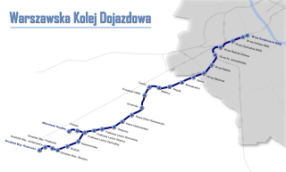
Warsaw Commuter Railway is a light rail commuter line in Poland's capital city of Warsaw. The line, together with its two branches, links Warsaw with the municipalities of Michałowice, Pruszków, Brwinów, Podkowa Leśna, Milanówek and Grodzisk Mazowiecki to the south-west of Warsaw.
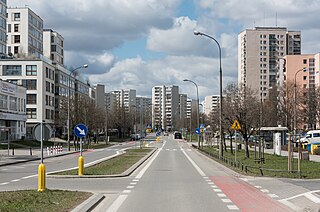
Włochy is one of the districts of Warsaw, located in the south-western part of city. Włochy borders districts Bemowo and Wola from the north, Ochota and Mokotów from the east, and Ursus and Ursynów from the south. It is one of 3 neighborhoods with the title of a garden town.
Wyględów is a neighbourhood, and the City Information System area, located in Warsaw, Poland, within the district of Mokotów.
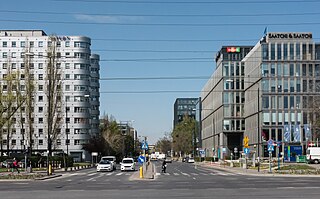
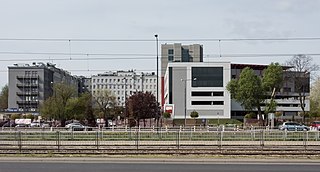
Służewiec is a neighbourhood, and an area of the City Information System, in the city of Warsaw, Poland, located within the district of Mokotów. Most of the neighbourhood consists of office buildings, which form one of the biggest complexes of office buildings in Poland, and one of the most important office centres in the city. It contains many headquarters of branches of many domestic and multinational corporations. A small portion of the neighbourhood also forms a residential area with apartment buildings.
Warszawa Włochy railway station is a railway station in the Włochy district of Warsaw, Poland. It stands on the junction of lines 1 and 3: from here trains can either run on Line 1 towards Łódź or Line 3 towards Poznań. It comprises two platforms connected by an undeground pedestrian tunnel and a station building complete with ticket machines and bicycle parking.
Staw Zbarski is a small pond in Warsaw in the district of Włochy.
Jelonki, prior to 1951 known as Jelonek, is a residential neighbourhood in the city of Warsaw, Poland, located within the district of Bemowo. The City Information System divides the neighbourhood into two areas, Jelonki Północne and Jelonki Południowe.
Odolany is a neighbourhood, and an area of the City Information System, in the city of Warsaw, Poland, located within the district of Wola.
Dąbrówka is a municipal neighbourhood, and a City Information System area, in Warsaw, Poland, within the district of Ursynów. It is a residencial area, consisting of single-family housing.
Załuski is a neighbourhood, and an area of the City Information System, in the city of Warsaw, Poland, located within the district of Włochy.
Salomea is a neighbourhood, and an area of the Municipal Information System, in the city of Warsaw, Poland, located within the district of Włochy.
Wiktoryn is a residential neighbourhood in the city of Warsaw, Poland, located within the district of Włochy, in the City Information System area of Stare Włochy.
Wyczółki is a neighbourhood, and a City Information System area, located in Warsaw, Poland, within the district of Ursynów. It is a mixed area, consisting of residencial zones, as well as business office complexes and storage warehouses.
Grabów is a neighbourhood, and a City Information System area, located in Warsaw, Poland, within the district of Ursynów. It consists mostly of the low-rise residential buildings.
Krasnowola is a neighbourhood in Warsaw, Poland, located within the district of Ursynów, in the City Information System area of Grabów. It is centred around Krasnowolska Street, and mostly consists of single-family detached homes.
Jeziorki is a municipal neighbourhood in Warsaw, Poland, located within the district of Ursynów. It is encompassed within two areas of the City Information System: Jeziorki Północne and Jeziorki Południowe, and is traditionally divided into two parts: Nowe Jeziorki, and Jeziorki Polskie. The neighbourhood is a residencial area of lowrise single-family housing.
Stary Imielin, also known as West Ursynów, is a neighbourhood, and a City Information System area, located in Warsaw, Poland, within the district of Ursynów.
Ursynów-Centrum, also known as South Ursynów, is a neighbourhood, and a City Information System area, located in Warsaw, Poland, within the district of Ursynów.
Na Skraju is a neighbourhood in Warsaw, Poland, located within the district of Ursynów, in the eastern portion of the City Information System area of Ursynów-Centrum.