The Cumberland Gap is a pass through the long ridge of the Cumberland Mountains, within the Appalachian Mountains, near the junction of the U.S. states of Kentucky, Virginia, and Tennessee.

Loom is an unincorporated community in Hampshire County, West Virginia, United States. Loom is located between Capon Bridge and Hanging Rock along the Northwestern Turnpike on the western flanks of Cooper Mountain. Timber Mountain Road and Beck's Gap Road converge at Loom on U.S. Route 50.
Back Creek is a 59.5-mile-long (95.8 km) tributary of the Potomac River that flows north from Frederick County, Virginia, to Berkeley County in West Virginia's Eastern Panhandle. Back Creek originates along Frederick County's border with Hampshire County, West Virginia, at Farmer's Gap in the Great North Mountain. Its name reflects its location to the west of North Mountain. The perspective of colonists from the east in the 18th century led them to call it "Back Creek", because it lay to the back of North Mountain.
Circleville is an unincorporated community located in Pendleton County, West Virginia, United States. Circleville was originally named Zyrkleville after John Zyrkle, who ran a dry goods store in the town. The old Circleville School is listed on the National Register of Historic Places.
Kline is an unincorporated community located in Pendleton County, West Virginia, United States. Originally known as Clines Cross Roads, its name was changed to Kline in about 1875. The name comes from Samuel Kline, an early postmaster.

Tomahawk is an unincorporated community on Back Creek in Berkeley County, West Virginia. The community is named for a nearby series of springs in the shape of a tomahawk. The community includes the historic Tomahawk Presbyterian Church, established c. 1745, and its adjacent community cemetery, which has gravestones dating to the late 18th century.
Greenland is an unincorporated community between Walker's Ridge and New Creek Mountain on the North Fork Patterson Creek in Grant County, West Virginia, United States. Greenland lies at the western end of Greenland Gap in New Creek Mountain.
The original county seat of Grant County, Maysville is an unincorporated community on North Fork Lunice Creek in Grant County, West Virginia, United States. The community lies at the eastern approach of Mays Gap in Knobly Mountain along West Virginia Route 42.
Scherr is an unincorporated community in Grant County, West Virginia, United States. The community's name is pronounced like "sheer." Scherr lies to the west of the community of Greenland at the crossroads of West Virginia Route 42, West Virginia Route 93, and U.S. Route 48. Scherr is home to a rock quarry, asphalt plant, and a small country store.

Ennis is an unincorporated community in McDowell County, West Virginia, United States. Ennis lies on U.S. Route 52 west of Switchback.

North Mountain is a mountain ridge within the Ridge-and-valley Appalachians in the U.S. states of Virginia and West Virginia.

State Route 9 is a primary state highway in the U.S. state of Virginia. Known as Charles Town Pike, the state highway runs 13.08 miles (21.05 km) from the West Virginia state line near Mechanicsville, where the highway continues west as West Virginia Route 9, east to SR 7 and SR 7 Business in Paeonian Springs. SR 9 is the main east–west highway of northwestern Loudoun County, connecting Leesburg with Hillsboro and the West Virginia cities of Charles Town and Martinsburg. As a result, the state highway and its West Virginia continuation are a major, overburdened commuter route between the Eastern Panhandle of West Virginia and Washington, D.C..
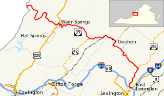
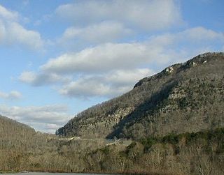
State Route 39 is a primary state highway in the U.S. state of Virginia. The state highway runs 59.17 miles (95.22 km) from the West Virginia state line near Mountain Grove, where the highway continues as West Virginia Route 39, east to U.S. Route 11 in East Lexington. SR 39 connects Lexington with several communities formed around hot springs in Bath County. In Rockbridge County, the state highway passes through the town of Goshen and Goshen Pass, a gorge formed by the Maury River.
Gap Mills is an unincorporated community in Monroe County, West Virginia, in the United States. Established in 1775 and located on West Virginia Route 3 east of Union, Gap Mills has a post office with ZIP code 24941.

Kiahsville is an unincorporated community in southern Wayne County, West Virginia, United States. It is a part of the Huntington-Ashland, WV-KY-OH, Metropolitan Statistical Area (MSA). As of the 2000 census, the MSA had a population of 288,649. Its sister town is nearby Cove Gap.
Dellslow is an unincorporated community in Monongalia County, West Virginia, United States. Dellslow was established in 1798 and is located along West Virginia Route 7 near the southern border of Brookhaven. Dellslow has a post office with ZIP code 26531.
Sprague is an unincorporated community and coal town in Raleigh County, West Virginia, United States. Sprague is located on West Virginia Route 16 1 mile (1.6 km) north of downtown Beckley. Sprague has a post office with ZIP code 25926.
Dott is an unincorporated community and coal town in Mercer County, West Virginia, United States. Dott is 3.1 miles (5.0 km) northwest of Matoaka. 1 mile (1.6 km) north of Springton Dott was commonly known by "Turkey Gap Consolidated Coal Company " which was part of Dott Coal town
Pond Gap is an unincorporated community in Kanawha County, West Virginia, United States. Pond Gap is 7 miles (11 km) north-northeast of Smithers. Pond Gap has a post office with ZIP code 25160.
Judy Gap is an unincorporated community in Pendleton County, West Virginia, United States. Judy Gap is located at the junction of U.S. Route 33 and West Virginia Route 28 8.5 miles (13.7 km) west-northwest of Franklin, just west of the mountain gap also called Judy Gap. The Judy Rocks geological formation is just to the south. North Fork Mountain is to the east, and the North Fork of the South Branch of the Potomac River is to the west, with Spruce Mountain and Spruce Knob beyond the river. Most of the surrounding land is within the Monongahela National Forest.


