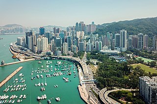
Causeway Bay is an area and a bay on Hong Kong Island,Hong Kong,straddling the border of the Eastern and the Wan Chai districts. It is a major shopping,leisure and cultural centre in Hong Kong,with a number of major shopping centres. The rents in the shopping areas of Causeway Bay were ranked as the world's most expensive for around a decade after overtaking New York City's Fifth Avenue in 2012. When referring to the area,the Cantonese name "Tung Lo Wan" is never written in English;"Causeway Bay" is always used.

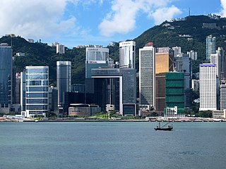
Central,also known as Central District,is the central business district of Hong Kong. It is located in the northeastern corner of the Central and Western District,on the north shore of Hong Kong Island,across Victoria Harbour from Tsim Sha Tsui,the southernmost point of Kowloon Peninsula. The area was the heart of Victoria City,although that name is rarely used today.
Admiralty is the eastern extension of the central business district on the Hong Kong Island of Hong Kong. It is located on the eastern end of the Central and Western District,bordered by Wan Chai to the east and Victoria Harbour to the north.

Mid-Levels is an affluent residential area on Hong Kong Island in Hong Kong. It is located between Victoria Peak and Central. Residents are predominantly more affluent Hong Kong locals and expatriate professionals.

Sheung Wan is an area in Hong Kong,located in the north-west of Hong Kong Island,between Central and Sai Ying Pun. Administratively,it is part of the Central and Western District. The name can be variously interpreted as Upper District,or Gateway District.

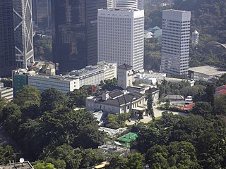
The former Central Police Station of Hong Kong is located at the eastern end of Hollywood Road,in Central,Hong Kong. It has been redeveloped into a cultural and shopping destination generally called Tai Kwun (大館). Tai Kwun is composed of three declared monuments:the former Central Police Station,former Central Magistracy and Victoria Prison.
The Government Hill is a hill in Central,Hong Kong,bounded by upper section of Upper Albert Road on the south,Queen's Road Central north,Garden Road east,and Glenealy,west of Hong Kong Island.

The Former French Mission Building is a declared monument located on Government Hill at 1,Battery Path,Central,Hong Kong. It housed the Court of Final Appeal of Hong Kong from 1 July 1997 to 6 September 2015.
Salisbury Road is a major road in Tsim Sha Tsui,Kowloon,Hong Kong.
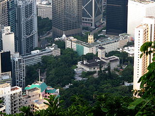
The Former Central Government Offices,now called Justice Place,is an office building complex that formerly housed most of the major offices of the Hong Kong Government. The complex is located in Central,Hong Kong,occupying the lower level of Government Hill. The offices of the government have been relocated to the Main Block of the Central Government Complex,Tamar.

Garden Road is a major road on Hong Kong Island,Hong Kong,connecting the Central and Mid-Levels areas. It was formerly known as Albany Nullah.

Caine Road is a road running through Mid-Levels,Hong Kong. It connects Bonham Road to the west,and Arbuthnot Road,Glenealy and Upper Albert Road to the east.

Founded by Benny Chia in 1984,the Fringe Club is a not-for-profit arts organisation. Its mission is to help emergent artists,promote Hong Kong artists abroad through cultural exchange and overseas touring,and conserve and develop Hong Kong cultural heritage.

Star Ferry Pier,Central may refer to any of the successive generations of Central Ferry Piers in Central,Hong Kong used by the Star Ferry for its services across Victoria Harbour to Tsim Sha Tsui Ferry Pier and until April 2011,to Hung Hom Pier. The current Star Ferry pier is the fourth to bear the name in Central. It opened for public service on 12 November 2006.

The General Post Office (GPO) is the headquarters of Hongkong Post. Built in 1976,it is located at Connaught Place,Central,Hong Kong. The office was adjacent to the former Star Ferry Pier,and it is adjacent to Jardine House and the International Finance Centre. The current building occupied a seafront location until 2007,since when reclamation works have led to it becoming inland.
Ice House Street is a one-way street in Central,Hong Kong Island,Hong Kong. Named after the structure previously located on it that housed the city's only source of ice,it stretches from Lower Albert Road to Connaught Road. The street is noted for several historical landmarks situated on it,most notably the Club Lusitano and the Old Dairy Farm Depot.

Glenealy is one of the few roads or streets without a street type suffix in Hong Kong. Located in the Mid-Levels on the Hong Kong Island,Hong Kong,it starts from Ice House Street and goes uphill to Hong Kong Zoological and Botanical Gardens,across Robinson Road and ends at Hornsey Road and Conduit Road.

Upper Albert Road is a road on the Government Hill in the Central area of Hong Kong.
The Old Dairy Farm Depot,or Old Dairy Farm Building,is a building in Central,Hong Kong,which currently houses the Hong Kong Fringe Club and the Foreign Correspondents' Club. It is located at 2 Lower Albert Road. The back of the building is located along Wyndham Street,while its edge faces Glenealy.
The Central and Western District located on northwestern part of Hong Kong Island is one of the 18 administrative districts of Hong Kong. It had a population of 243,266 in 2016. The district has the most educated residents with the second highest income and the third lowest population due to its relatively small size.

