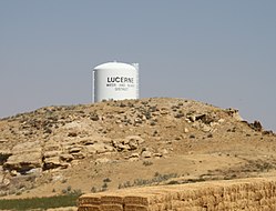
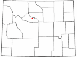
Lucerne, Wyoming | |
---|---|
Coordinates: 43°44′6″N108°10′34.5″W / 43.73500°N 108.176250°W Coordinates: 43°44′6″N108°10′34.5″W / 43.73500°N 108.176250°W [1] | |
Country | United States |
State | Wyoming |
County | Hot Springs |
Area | |
• Total | 20.6 sq mi (53 km2) |
• Land | 19.9 sq mi (52 km2) |
• Water | 0.7 sq mi (2 km2) |
Elevation | 4,314 ft (1,315 m) |
Population | |
• Total | 548 |
• Density | 27/sq mi (10/km2) |
Time zone | UTC-7 (Mountain (MST)) |
• Summer (DST) | UTC-6 (MDT) |
Area code(s) | 307 |
FIPS code | 56-48240 [3] |
GNIS feature ID | 1597627 [4] |
Lucerne is a census-designated place (CDP) in Hot Springs County, Wyoming, United States. The population was 535 at the 2010 census.
Lucerne is located on U.S. Route 20 between Thermopolis and Worland.
According to the United States Census Bureau, the CDP has a total area of 20.6 square miles (53.3 km2), of which 19.9 square miles (51.5 km2) is land and 0.7 square mile (1.7 km2) (3.22%) is water. [5]
As of the census [3] of 2000, there were 525 people, 208 households, and 170 families residing in the CDP. The population density was 26.5 people per square mile (10.2/km2). There were 224 housing units at an average density of 11.3/sq mi (4.4/km2). The racial makeup of the CDP was 98.29% White, 0.19% African American, 0.19% Native American, 0.19% Asian, 0.38% from other races, and 0.76% from two or more races. Hispanic or Latino of any race were 1.52% of the population.
There were 208 households, out of which 30.3% had children under the age of 18 living with them, 74.5% were married couples living together, 4.8% had a female householder with no husband present, and 17.8% were non-families. 15.4% of all households were made up of individuals, and 6.7% had someone living alone who was 65 years of age or older. The average household size was 2.52 and the average family size was 2.79.
In the CDP, the population was spread out, with 23.0% under the age of 18, 5.3% from 18 to 24, 27.0% from 25 to 44, 32.4% from 45 to 64, and 12.2% who were 65 years of age or older. The median age was 43 years. For every 100 females, there were 101.1 males. For every 100 females age 18 and over, there were 102.0 males.
The median income for a household in the CDP was $49,063, and the median income for a family was $47,813. Males had a median income of $24,464 versus $16,083 for females. The per capita income for the CDP was $19,998. About 3.6% of families and 2.7% of the population were below the poverty line, including none of those under the age of eighteen or sixty-five or over.
Public education in the community of Lucerne is provided by Hot Springs County School District #1. Schools in the district include Ralph Witters Elementary School (grades K-5), Thermopolis Middle School (grades 6–8), and Hot Springs County High School (grades 9–12).
Hot Springs County is a county in the U.S. state of Wyoming. As of the 2020 United States Census, the population was 4,696, making it the second-least populous county in Wyoming. Its county seat is Thermopolis. The county is named for the hot springs located in Hot Springs State Park.
Lucernemines, usually written as Lucerne Mines, is a census-designated place (CDP) in Indiana County, Pennsylvania, United States. The population was 937 at the 2010 census.
Hyattville is a census-designated place (CDP) in Big Horn County, Wyoming, United States. The population was 75 at the 2010 census.
Meadowlark Lake is an unincorporated community in Big Horn County, Wyoming, United States. The population was 8 at the 2000 census, when it was a Census-designated place (CDP).
Esterbrook is a village, and the locus of a same-named census-designated place (CDP), in Converse County, Wyoming, United States in the Medicine Bow National Forest. The population was 52 at the 2010 census.
East Thermopolis is a town in Hot Springs County, Wyoming, United States. The population was 229 at the 2020 census.
Kirby is a town in Hot Springs County, Wyoming, United States.
Owl Creek is a tiny hamlet in Hot Springs County, Wyoming, United States. The population was five at the 2010 Census. Owl Creek is also a part of the Owl Creek, Wyoming Census Designated Place (CDP). Google Maps has never bothered to visit Owl Creek or the CDP, as of 2021.
Thermopolis is the largest town in Hot Springs County, Wyoming, United States, and also the county seat. As of the 2020 U.S. Census, the town population was 2,725.
Alpine Northwest is a census-designated place (CDP) in Lincoln County, Wyoming, United States. The population was 244 at the 2010 census.
Alcova is a census-designated place (CDP) in Natrona County, Wyoming, United States. It is part of the Casper, Wyoming Metropolitan Statistical Area. The population was 76 at the 2010 census. The center of population for the CDP is located in the small Town of Alcova. Alcova and the nearby reservoir, Alcova Lake, are popular vacation spots with many seasonal residents.
Bondurant is a census-designated place (CDP) in Sublette County, Wyoming, United States. The population was 93 at the 2010 census. The town was named after B. F. Bondurant.
Washam is a census-designated place (CDP) in Sweetwater County, Wyoming, United States. The population was 51 at the 2010 census.
Alta is a census-designated place (CDP) in Teton County, Wyoming, United States. The population was 394 at the 2010 census. It is part of the Jackson, WY–ID Micropolitan Statistical Area, and it is located between Driggs, Idaho and the Grand Targhee ski resort.
Hoback is a census-designated place (CDP) in Teton County, Wyoming, United States. The population was 1,176 at the 2010 census. It is part of the Jackson, WY–ID Micropolitan Statistical Area. The town is named for John Hoback, a mountain man who guided the Astor party through the area in 1811.
Wilson is a census-designated place (CDP) in Teton County, Wyoming, United States. The population was 1,482 at the 2010 census, up from 1,294 in 2000. It is part of the Jackson, WY–ID Micropolitan Statistical Area.
Carter is a census-designated place (CDP) in Uinta County, Wyoming, United States. The community was named after Judge William A. Carter. The population was 10 at the 2010 census.
Lonetree is a census-designated place (CDP) in Uinta County, Wyoming, United States. The population was 49 at the 2010 census.
Robertson is a census-designated place (CDP) in Uinta County, Wyoming, United States. The population was 97 at the 2010 census.
Mc Nutt is an unincorporated community in Washakie County, Wyoming, United States. The population was 278 at the 2000 census, when it was a census-designated place (CDP).