East Thermopolis, Wyoming

Last updated

East Thermopolis, Wyoming
Hot Springs County Wyoming Incorporated and Unincorporated areas East Thermopolis Highlighted 5622720.svg
Location of East Thermopolis in Hot Springs County, Wyoming.
Usa edcp location map.svg
Red pog.svg
East Thermopolis, Wyoming
Location in the United States
Coordinates: 43°38′47″N108°11′53″W / 43.64639°N 108.19806°W / 43.64639; -108.19806
Country United States
State Wyoming
County Hot Springs
Area
[1]
  Total0.18 sq mi (0.47 km2)
  Land0.18 sq mi (0.47 km2)
  Water0.00 sq mi (0.00 km2)
Elevation
[2]
4,341 ft (1,323 m)
Population
 (2020) [3]
  Total229
  Density1,314.92/sq mi (506.55/km2)
Time zone UTC-7 (Mountain (MST))
  Summer (DST) UTC-6 (MDT)
Area code 307
FIPS code 56-22720 [4]
GNIS feature ID1597608 [2]

East Thermopolis is a town in Hot Springs County, Wyoming, United States. The population was 229 at the 2020 census.

Contents

Geography

According to the United States Census Bureau, the town has a total area of 0.18 square miles (0.47 km2), all land. [5]

Demographics

Historical population
CensusPop.Note
1950 246
1960 28114.2%
1970 31612.5%
1980 35913.6%
1990 221−38.4%
2000 27424.0%
2010 254−7.3%
2020 229−9.8%
U.S. Decennial Census [6]

2010 census

As of the census [3] of 2010, there were 254 people, 157 households, and 56 families residing in the town. The population density was 1,411.1 inhabitants per square mile (544.8/km2). There were 186 housing units at an average density of 1,033.3 per square mile (399.0/km2). The racial makeup of the town was 93.7% White, 0.8% African American, 3.9% Native American, 0.4% from other races, and 1.2% from two or more races. Hispanic or Latino of any race were 0.8% of the population.

There were 157 households, of which 7.6% had children under the age of 18 living with them, 31.8% were married couples living together, 1.9% had a female householder with no husband present, 1.9% had a male householder with no wife present, and 64.3% were non-families. 60.5% of all households were made up of individuals, and 42.1% had someone living alone who was 65 years of age or older. The average household size was 1.55 and the average family size was 2.36.

The median age in the town was 64.8 years. 11.4% of residents were under the age of 18; 3.5% were between the ages of 18 and 24; 9% were from 25 to 44; 26.7% were from 45 to 64; and 49.2% were 65 years of age or older. The gender makeup of the town was 47.2% male and 52.8% female.

2000 census

As of the census [4] of 2000, there were 274 people, 150 households, and 61 families residing in the town. The population density was 1,565.8 people per square mile (622.3/km2). There were 166 housing units at an average density of 948.6 per square mile (377.0/km2). The racial makeup of the town was 91.97% White, 0.36% African American, 1.46% Native American, 1.09% from other races, and 5.11% from two or more races. Hispanic or Latino of any race were 3.65% of the population.

There were 150 households, out of which 16.0% had children under the age of 18 living with them, 31.3% were married couples living together, 7.3% had a female householder with no husband present, and 59.3% were non-families. 56.0% of all households were made up of individuals, and 38.7% had someone living alone who was 65 years of age or older. The average household size was 1.75 and the average family size was 2.61.

In the town, the population was spread out, with 21.2% under the age of 18, 4.7% from 18 to 24, 16.1% from 25 to 44, 25.5% from 45 to 64, and 32.5% who were 65 years of age or older. The median age was 55 years. For every 100 females, there were 79.1 males. For every 100 females age 18 and over, there were 64.9 males.

The median income for a household in the town was $18,056, and the median income for a family was $30,313. Males had a median income of $21,250 versus $17,386 for females. The per capita income for the town was $11,280. About 7.0% of families and 16.8% of the population were below the poverty line, including 9.8% of those under the age of eighteen and 22.4% of those 65 or over.

Education

Public education in the town of East Thermopolis is provided by Hot Springs County School District #1. Schools in the district include Ralph Witters Elementary School (grades K-5), Thermopolis Middle School (grades 6-8), and Hot Springs County High School (grades 9-12).

Related Research Articles

<span class="mw-page-title-main">Hot Springs County, Wyoming</span> County in Wyoming, United States

Hot Springs County is a county in the U.S. state of Wyoming. As of the 2020 United States Census, the population was 4,696, making it the second-least populous county in Wyoming. Its county seat is Thermopolis. The county is named for the hot springs located in Hot Springs State Park.

<span class="mw-page-title-main">Steele, Alabama</span> Town in Alabama, United States

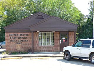
Steele is a town in northeastern St. Clair County, Alabama, United States. It was incorporated in 1952. At the 2010 census the population was 1,043, down from 1,093. The town is a part of the Birmingham–Hoover–Cullman Combined Statistical Area. It was initially known as Steel's Station or Steele's Depot in the late 19th century.

<span class="mw-page-title-main">Eagle Lake, Maine</span> Town in the state of Maine, United States

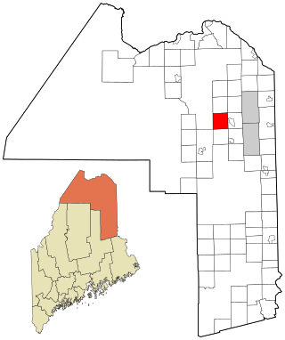
Eagle Lake is a town in Aroostook County, Maine, United States. The population was 772 at the 2020 census. The town was named by a body of troops heading from Bangor to the Aroostook War for the many eagles that they saw around the lake. A total of 49.0% of the population speaks French, reflecting a trend in Northeastern Maine.

<span class="mw-page-title-main">Mapleton, Maine</span> Town in the state of Maine, United States

Mapleton is a town in Aroostook County, Maine, United States. The population was 1,886 at the 2020 census.

<span class="mw-page-title-main">Merrill, Maine</span> Town in the state of Maine, United States

Merrill is a town in Aroostook County, Maine, United States. The population was 208 at the 2020 census.

<span class="mw-page-title-main">Perham, Maine</span> Town in the state of Maine, United States

Perham is a town in Aroostook County, Maine, United States. The population was 371 at the 2020 census. The town was named after Maine's 33rd governor, Sidney Perham.

<span class="mw-page-title-main">Wade, Maine</span> Town in the state of Maine, United States

Wade is a town in Aroostook County, Maine, United States. The population was 229 at the 2020 census.

<span class="mw-page-title-main">Vienna, Maine</span> Town in the state of Maine, United States

Vienna is a town in Kennebec County, Maine, United States. The population was 578 at the 2020 census.

<span class="mw-page-title-main">Hartford, Maine</span> Town in the state of Maine, United States

Hartford is a town in Oxford County, Maine, United States. Hartford is included in the Lewiston-Auburn, Maine metropolitan New England City and Town Area. The population was 1,203 at the 2020 census.

Kenduskeag is a town in Penobscot County, Maine, United States. The population was 1,346 at the 2020 census.

Lakeville is a town in Penobscot County, Maine, United States. The population was 104 at the 2020 census.

Lowell is a town in Penobscot County, Maine, United States. The population was 368 at the 2020 census.

Winn is a town in Penobscot County, Maine, United States, on the east bank of the Penobscot River. The town was named for John M. Winn, an early landholder. The population was 399 at the 2020 census.

<span class="mw-page-title-main">Abbot, Maine</span> Town in the state of Maine, United States

Abbot is a town in Piscataquis County, Maine, United States. The population was 650 at the 2020 census. It was named for the treasurer of Bowdoin College, John Abbot.

<span class="mw-page-title-main">Burnham, Maine</span> Town in the state of Maine, United States

Burnham is a town in Waldo County, Maine, United States. The population was 1,096 at the 2020 census.

<span class="mw-page-title-main">Pine Grove, West Virginia</span> Town in West Virginia, United States

Pine Grove is a town in Wetzel County, West Virginia, United States. The population was 363 at the 2020 census. The community was named for a grove of pine trees near the original town site.

<span class="mw-page-title-main">North Hills, West Virginia</span> Town in West Virginia, United States

North Hills is a town in Wood County, West Virginia, United States. It is a suburb of Parkersburg. The population was 837 at the 2020 census. North Hills was incorporated on February 15, 1979.

<span class="mw-page-title-main">Kirby, Wyoming</span> Town in Wyoming, United States

Kirby is a town in Hot Springs County, Wyoming, United States.

<span class="mw-page-title-main">Lucerne, Wyoming</span> CDP in Wyoming, United States

Lucerne is a census-designated place (CDP) in Hot Springs County, Wyoming, United States. The population was 535 at the 2010 census.

<span class="mw-page-title-main">St. Albans, Maine</span> Town in the state of Maine, United States

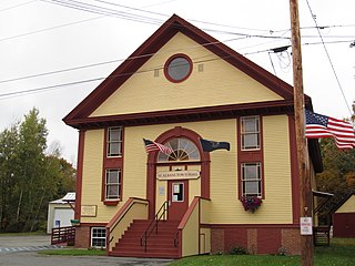
St. Albans is a town in Somerset County, Maine, United States. The population was 2,045 at the 2020 census.

References

  1. "2019 U.S. Gazetteer Files". United States Census Bureau. Retrieved August 7, 2020.
  2. 1 2 U.S. Geological Survey Geographic Names Information System: East Thermopolis, Wyoming
  3. 1 2 "U.S. Census website". United States Census Bureau . Retrieved December 14, 2012.
  4. 1 2 "U.S. Census website". United States Census Bureau . Retrieved January 31, 2008.
  5. "US Gazetteer files 2010". United States Census Bureau. Archived from the original on January 25, 2012. Retrieved December 14, 2012.
  6. "Census of Population and Housing". Census.gov. Retrieved June 4, 2015.