Luis A. "Wito" Morales Park

Last updated
Luis A. "Wito" Morales Park
Parque Luis A. Wito Morales, Barrio Maraguez, Ponce, PR (DSC02593).jpg
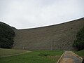
The Luis A. "Wito" Morales Park.
Luis A. "Wito" Morales Park
Type Passive park
Location PR-139, km. 3.3, in Ponce, Puerto Rico [1]
Coordinates 18°04′21.24″N66°34′34.37″W / 18.0725667°N 66.5762139°W / 18.0725667; -66.5762139
Areaapprox 200 cuerdas including neighboring forests and nearby Cerrillos State Forest
Created2006 [2]
Operated by Autonomous Municipality of Ponce
StatusOpened daily 9AM to 5PM, except Mondays

The Luis A. "Wito" Morales Park (Spanish: Parque Luis A. "Wito" Morales) is a park in the municipality of Ponce, Puerto Rico. It is part of the Lake Cerrillos Dam recreational area.

Contents

Location

The park is located at the southern end of Lake Cerrillos, immediately south of the Cerrillos Dam, in Barrio Maragüez. It can be reached via Puerto Rico Highway 139.

It is surrounded by mountains, abundant in vegetation, and it is at the center of the Cerrillos State Forest, which is located 4 miles northeast of the city of Ponce. [3]

Name

The park was so named after an Act of the Legislature of Puerto Rico on 12 December 2006, (No. 262, §§ 1, 2.) [4] It was named in honor of "Wito" Morales, mayor of Ponce from 1972 to 1976 and former Puerto Rico senator. Wito Morales was also president of the Ponce Municipal Assembly from 1989 to 2005. Prior to his years in politics, Wito Morales was as sportscaster for the Ponce Lions professional baseball team. He had himself also played with the Lions from 1947 to 1953, and is recognized at the Tricentennial Park as well as at Ponce's Sports Hall of Fame, the Francisco Pancho Coimbre Museum. [5]

History

The park was inaugurated in 2006. [6] It was built as part of the plans for the creation of the Cerrillos Dam. The Wito Morales Park, together with the forest area in the vicinity of the Cerrillos Dam occupies an area of some 200 cuerdas of land set aside for recreational purposes under an Executive Order. [7]

Amenities

This park includes basketball, "beach" volleyball and baseball facilities, a fresh water pond, an aquatic play yard, a children's playground, and 20 large gazebos, most of them equipped with BBQ pits. [8]

Related Research Articles

<span class="mw-page-title-main">Ponce, Puerto Rico</span> City and municipality of Puerto Rico

Ponce is both a city and a municipality on the southern coast of Puerto Rico. The city is the seat of the municipal government.

<span class="mw-page-title-main">Rafael Cordero Santiago</span> Puerto Rican politician

Rafael Cordero Santiago, better known as "Churumba", was the Mayor of Ponce, Puerto Rico, from 1989 to 2004. Many considered him as a synonym of Ponce, being baptized as "El León Mayor", an allusion to the city's official symbol, the lion. Mayor Cordero was a firm believer in the government decentralization process.

<span class="mw-page-title-main">Index of Puerto Rico–related articles</span>

The following is an alphabetical list of articles related to the Commonwealth of Puerto Rico.

<span class="mw-page-title-main">Luis A. Morales</span> Puerto Rican politician

Luis Antonio ("Wito") Morales Crespo was a Puerto Rican politician and Mayor of Ponce, Puerto Rico, from 1973 to 1976. He was also Senator for the District of Ponce from 1977 to 1980 and president of the Ponce Municipal Assembly from 1989 to 2004 He is recognized as a politician, sportsman, and sports broadcaster.

<span class="mw-page-title-main">Portugués River</span> River of Puerto Rico

Río Portugués is a river in the municipality of Ponce, Puerto Rico. In the 19th century, it was also known as Río de Ponce. Twenty-one bridges for motor vehicle traffic span Río Portugués in the municipality of Ponce alone. The river is also known as Río Tibes in the area where it flows through barrio Tibes in the municipality of Ponce. Río Portugués has a length of nearly 30 kilometers (19 mi) and runs south from the Cordillera Central mountain range into the Caribbean Sea. The Portugués is one of the best-known rivers in Ponce because of its prominent zigzagging through the city and its historical significance. The river is historically significant because the city of Ponce had its origins on its banks. It was originally known as Río Baramaya. It has its mouth at 17°58′51″N66°37′26″W. This river is one of the 14 rivers in the municipality.

<span class="mw-page-title-main">Parque Pedro Albizu Campos</span> Passive recreational park in the city of Ponce, Puerto Rico

The Parque Pedro Albizu Campos is a passive recreational park in the city of Ponce, Puerto Rico. It was dedicated on 12 September 1991, to the memory of Puerto Rican Nationalist leader Pedro Albizu Campos by the Government of the Autonomous Municipality of Ponce. Dr. Pedro Albizu Campos was born in Ponce on 12 September 1891. He was raised in Ponce and lived most of his life there as well.

<span class="mw-page-title-main">El Tuque</span> Beach in Ponce, Puerto Rico

El Tuque is a beach and family recreational and tourist complex in the Punta Cucharas sector of Barrio Canas in Ponce, Puerto Rico. It was designed in the early 1960s by Luis Flores, an architect from Cayey, Puerto Rico. It is located on PR-2, Km 220.1, in the El Tuque sector of Barrio Canas in Ponce. The sector of El Tuque is considered Puerto Rico's largest populated sector. The beach opened on 17 July 1965.

<span class="mw-page-title-main">Maragüez</span> Barrio of Ponce, Puerto Rico

Maragüez is one of the 31 barrios of the municipality of Ponce, Puerto Rico. Along with Magueyes, Tibes, Portugués, Montes Llanos, Machuelo Arriba, Sabanetas, and Cerrillos, Maragüez is one of the municipality's eight rural interior barrios. The name of this barrio is of native Indian origin. It was created in 1878.

<span class="mw-page-title-main">Cerrillos, Ponce, Puerto Rico</span> Barrio of Puerto Rico

Cerrillos is one of the 31 barrios of the municipality of Ponce, Puerto Rico. Along with Magueyes, Tibes, Portugués, Montes Llanos, Maragüez, and Machuelo Arriba, Cerrillos is one of the municipality's seven interior rural barrios. It was founded in 1878.

<span class="mw-page-title-main">Cerrillos River</span> River of Puerto Rico

Cerrillos River is a river in the municipality of Ponce, Puerto Rico. Río Cerrillos has its origin in barrio Anón and runs south until it feeds into Bucaná River. Río Cerrillos is commonly known by the locals as Maragüez River, because most of its course runs through Barrio Maragüez. This river is one of the 14 rivers in the municipality. The river has a discharge of 24,000 cubic feet per second, making it the second most affluent river in the municipality after Río Jacaguas.

<span class="mw-page-title-main">Parque del Tricentenario (Ponce, Puerto Rico)</span> Passive urban park in Ponce, Puerto Rico

Parque del Tricentenario is a passive urban park in the city of Ponce, Puerto Rico. The park was built to commemorate the 300th anniversary of the founding of the city. It was inaugurated during the mayoral administration of mayor Rafael Cordero Santiago.

<span class="mw-page-title-main">Lake Cerrillos</span> Human-made lake located in Maragüez, Ponce, Puerto Rico

Lake Cerrillos is a human-made lake located in barrio Maragüez, Ponce, Puerto Rico. The lake was finished in 1992 by the U.S. Army Corps of Engineers. The main purposes of the reservoir are flood control, water supply, and recreation. There is a variety of fish available for fishing such as largemouth bass, bluegills, catfish and tilapias. The 1993 Central American and Caribbean Games that were held in Ponce staged the canoeing competitions in this lake. It was used in the 2010 Central American and Caribbean Games for the sports of Canoeing, Rowing. The lake is the main drinking water source for the city of Ponce.

<span class="mw-page-title-main">Puerto Rico Highway 139</span> Highway in Puerto Rico

Puerto Rico Highway 139 (PR-139) is a two-way secondary highway in the municipality of Ponce in Puerto Rico. With a length of 25.2 km (15.7 mi), it extends from the interchange of PR-10 and PR-14 located in Barrio Machuelo Arriba to the junction with PR-143 on the Ponce–Jayuya municipal limit.

<span class="mw-page-title-main">Francisco "Paquito" Montaner</span> Puerto Rican baseball player

Francisco ("Paquito") Montaner García was a Puerto Rican pitcher from Ponce. He was the first baseball player to throw a "no-hitter" in Puerto Rican baseball, an event that took place on 10 December 1911. He is honored with the name of one of the largest stadiums in Puerto Rico, the professional baseball league's Francisco Montaner Stadium in Ponce. In 1955, he was inducted into the Puerto Rico Sports Hall of Fame and, in 1983, into the Galeria de los Inmortales del Deporte Ponceño.

<span class="mw-page-title-main">Cerrillos State Forest</span> State forest in Puerto Rico

Cerrillos State Forest is one of the 21 state forests in Puerto Rico. It is located in barrio Maragüez, in the municipality of Ponce, and covers 200 cuerdas of valleys and mountains in the foothills of the Cordillera Central mountain range. The forest has several trails, observation areas, several picnic areas, complete with gazeebos and a man-made reservoir, Lake Cerrillos and the Lake Cerrillos dam.

The following is a timeline of the history of the city of Ponce, Puerto Rico.

<span class="mw-page-title-main">Puente de los Leones</span> Historic bridge in Ponce, Puerto Rico

The Puente de los Leones is a historic bridge in Ponce, Puerto Rico, joining Barrio Tercero to Barrio San Antón and Barrio Machuelo Abajo. It is also the city's best known bridge. The bridge is at the western terminus of Bulevar Miguel Pou, the main gateway to the Ponce Historic Zone. The Art Deco bridge carries four lanes of vehicular traffic from the two-way Miguel Pou Boulevard. It crosses Río Portugués connecting Barrio Tercero to the west with Barrios Machuelo Abajo and San Anton to the east. It is located 0.5 km east of Plaza Las Delicias.

References