
The Ganaraska River is a river in Northumberland County and the Regional Municipality of Durham in Southern Ontario, Canada. It is part of the Great Lakes Basin, and is a tributary of Lake Ontario, which it reaches at the central community of the municipality of Port Hope. The river's name is thought to originate from Ganaraske, the name for the Cayuga village which was located at the current site of Port Hope.

Scugog is a township in the Regional Municipality of Durham, south-central Ontario, Canada. It is northeast of Toronto and just north of Oshawa. Due to its location in the Greater Toronto Area, many residents commute to Toronto for work on a daily basis. The anchor and largest population base of the township is Port Perry. The township has a population of roughly 22,500. A smaller Scugog Township was also a historic municipality and geographic township prior to the amalgamation that formed the current municipality.
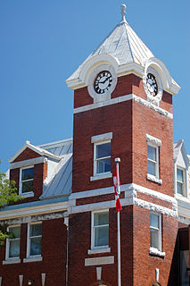
Port Perry is a community located in Scugog, Ontario, Canada. The town is located 84 km northeast of central Toronto and north of Oshawa and Whitby. Due to its location in the Greater Toronto Area, many residents commute to Toronto for work. Port Perry has a population of 9,453 as of 2016.

The Nottawasaga River is a river in Simcoe County and Dufferin County in Central Ontario, Canada. It is part of the Great Lakes Basin, and is a tributary of Lake Huron. The river flows from the Orangeville Reservoir in the town of Orangeville, Dufferin County, through the Niagara Escarpment and the Minesing Wetlands, the latter a wetland of international significance, and empties into Nottawasaga Bay, an inlet of Georgian Bay on Lake Huron, at the town of Wasaga Beach, Simcoe County.

The Seguin River is a river in Parry Sound District in central Ontario, Canada that empties into Parry Sound on Georgian Bay, Lake Huron at the town of Parry Sound. The river's name comes from the Ojibwe word ziigwan, meaning "spring".

Lake Scugog is an artificially flooded lake in Scugog, Regional Municipality of Durham and the unitary city of Kawartha Lakes in central Ontario, Canada. It lies between the communities of Port Perry and Lindsay. The lake has been raised and lowered several times over its history. Though not technically part of the Kawartha lakes due to its shallow depths, it is often geographically linked to them. Its sole outflow, the Scugog River, connects to Sturgeon Lake. Lake Scugog is in the Great Lakes Basin and forms part of the Trent–Severn Waterway.
Durham County is a historic county in Ontario, Canada. It was named from the English County Durham and city of Durham.

The Sauble River is a river in Bruce County and Grey County in southwestern Ontario, Canada that flows from its headwaters in the township of Chatsworth to Lake Huron at the community of Sauble Beach.
The Bayfield River is a river in Huron and Perth Counties in southwestern Ontario, Canada, that empties into Lake Huron at the community of Bayfield in the municipality of Bluewater.
The Maitland River is a river in Huron County, Perth County and Wellington County in Southwestern Ontario, Canada. The river is in the Great Lakes Basin and empties into Lake Huron at the town of Goderich. It is 150 kilometres (93 mi) long, and is named after Sir Peregrine Maitland, Lieutenant-Governor of Upper Canada from 1818 to 1828. It was formerly known as the Menesetung River.

The Crowe River is a river in the counties of Haliburton, Hastings, Northumberland and Peterborough in southern Ontario, Canada. It is in the Lake Ontario drainage basin and is a tributary of the Trent River.

Durham is a federal electoral district in Ontario, Canada, that has been represented in the House of Commons of Canada from 1904 to 1968, and since 1988.
Ontario was a federal electoral district represented in the House of Commons of Canada from 1925 to 1997. It was located in the province of Ontario. This riding was created in 1924 from Ontario South riding.

Brooklin is a community in the town of Whitby, Ontario, Canada. It is located north of the urban area of Whitby, at the south junction of Ontario Highways 12 and 7.
The Durham District School Board (DDSB), known as English-language Public District School Board No. 13 prior to 1999, is an Anglophone, secular public school board in Ontario, Canada. The DDSB serves most of the Regional Municipality of Durham, except for schools within the Municipality of Clarington, which belongs to the Kawartha Pine Ridge District School Board. The Durham District School Board Education Centre head office is in Whitby.

Ashburn is a hamlet in the town of Whitby, Durham Region, Ontario, Canada, located approximately 15 kilometres north of the town core, and centred on the intersection of Ashburn Road and Myrtle Road. It is a rural settlement area on the Oak Ridges Moraine, situated on the headwaters of the Lynde Creek watershed and part of Ontario's protected Golden Horseshoe Greenbelt.

Heber Down Conservation Area is located in Whitby, Ontario and is owned and operated by Central Lake Ontario Conservation Authority. It is located within the Lynde Creek drainage basin; it is a part of the provincially significant Heber Down Wetland Complex. The area is composed of two types of broad terrain units: a valley formed by the creek and the Glacial Lake Iroquois beach. The area provides such recreational activities as hiking, mountain biking, picnicking, and fishing.
The Beaver River is a river in Durham Region in Central Ontario, Canada. It is part of the Great Lakes Basin, and is a tributary of Lake Simcoe. The river's drainage basin is mostly in Durham Region with the remaining portion in the city of Kawartha Lakes; the entire watershed is under the auspices of the Lake Simcoe Region Conservation Authority.

The Black River is a river in the Regional Municipality of York and the Regional Municipality of Durham in Central Ontario, Canada. It is part of the Great Lakes Basin, and is a tributary of Lake Simcoe; the entire watershed is under the auspices of the Lake Simcoe Region Conservation Authority.
Oshawa Creek is a watercourse that flows 50 kilometres (31 mi) from its headwaters in the Oak Ridges Moraine to its mouth on Lake Ontario, at Oshawa, Ontario. It drains a watershed of 120 square kilometres (46 sq mi). In its lowest reaches, in Oshawa, two tributaries, Goodman's Creek and Montgomery Creek, join the watercourse.
