Lys, Pyrénées-Atlantiques

Last updated • 1 min readFrom Wikipedia, The Free Encyclopedia
Lys
Lys Bearn.jpg
General view of Lys
Blason ville fr Lys (Pyrenees-Atlantiques).svg
Location of Lys
Lys, Pyrenees-Atlantiques
France location map-Regions and departements-2016.svg
Red pog.svg
Lys
Aquitaine-Limousin-Poitou-Charentes region location map.svg
Red pog.svg
Lys
Coordinates: 43°07′52″N0°21′06″W / 43.1311°N 0.3517°W / 43.1311; -0.3517
Country France
Region Nouvelle-Aquitaine
Department Pyrénées-Atlantiques
Arrondissement Oloron-Sainte-Marie
Canton Oloron-Sainte-Marie-2
Intercommunality Vallée d'Ossau
Government
  Mayor (20202026) Nadège Poueymirou Bouchet [1]
Area
1
15.40 km2 (5.95 sq mi)
Population
 (2021) [2]
323
  Density21/km2 (54/sq mi)
Time zone UTC+01:00 (CET)
  Summer (DST) UTC+02:00 (CEST)
INSEE/Postal code
64363 /64260
Elevation304–510 m (997–1,673 ft)
(avg. 424 m or 1,391 ft)
1 French Land Register data, which excludes lakes, ponds, glaciers > 1 km2 (0.386 sq mi or 247 acres) and river estuaries.

Lys (French pronunciation: [lis] ; Occitan : Lo Lis) is a commune in the Pyrénées-Atlantiques department in southwestern France.

Contents

Geography

Hydrography

The river Landistou  [ fr ], a 12.5 km long tributary of the Béez, passes through the village Lys. Several tributaries of the Landistou (Betbeder, Bonnasserre, Chourrup, Lazerau, Lespereu) also pass through the commune. [3] The northern part of the commune is drained by the river Luz  [ fr ], a 15.2 km long tributary of the Gave de Pau, and some of its tributaries (Gest, Herran, Luz de Casalis). [4] The southern part of the commune is drained by the stream Ruisseau de la Fontaine de Mesplé (Béez basin), and its tributary Ruisseau de Subercase. [5]

Localities and Hamlets

Surrounding Communities

Toponymy

The name Lys appears as Lis-Sainte-Colomme (Lily Saint Colomme) from the 1721 census. The name comes from Gascony, and means 'flat land'.

History

Lys was formerly an annex of Sainte-Colome until it acquired municipality status in 1858. [6]

Administration

The current mayor is Nadège Poueymirou Bouchet, in office since 2020. [1]

The town is part of the following intercommunal structures:

Population

Historical population
YearPop.±% p.a.
1861 1,080    
1866 1,070−0.19%
1872 1,084+0.22%
1876 1,040−1.03%
1881 962−1.55%
1886 985+0.47%
1891 998+0.26%
1896 924−1.53%
1901 916−0.17%
1906 908−0.18%
1911 856−1.17%
1921 685−2.20%
1926 657−0.83%
YearPop.±% p.a.
1931 622−1.09%
1936 621−0.03%
1946 564−0.96%
1954 526−0.87%
1962 518−0.19%
1968 450−2.32%
1975 430−0.65%
1982 412−0.61%
1990 376−1.14%
1999 348−0.86%
2007 354+0.21%
2012 350−0.23%
2017 334−0.93%
Source: EHESS [6] and INSEE (1968-2017) [7]

Economy

The town's economy is primarily oriented toward agriculture and livestock (sheep, cattle, pigs, mules).

See also

Related Research Articles

<span class="mw-page-title-main">Gave d'Oloron</span> River in southwestern France

The Gave d'Oloron is a river of south-western France near the border with Spain. It takes its name from the city Oloron-Sainte-Marie, where it is formed from the rivers Gave d'Aspe and Gave d'Ossau. It joins the Gave de Pau in Peyrehorade to form the Gaves réunis, a tributary of the Adour. The Gave d'Oloron is used for fishing. The river is 148 kilometres (92 mi) long, including its source rivers Gave d'Ossau and Gave du Brousset. Near Sauveterre-de-Béarn it takes up its largest tributary, the Saison.

Aramits is a commune in the Pyrénées-Atlantiques department in the Nouvelle-Aquitaine region of south-western France.

<span class="mw-page-title-main">Hasparren</span> Commune in Nouvelle-Aquitaine, France

Hasparren is a commune in the Pyrénées-Atlantiques department in south-western France. A resident of Hasparren is known as a 'Hazpandar'.

<span class="mw-page-title-main">Néez (Pyrénées-Atlantiques)</span> River in France

The Néez of Gan is a left tributary of the Gave de Pau, in Béarn (Pyrénées-Atlantiques), in the Southwest of France. It flows into the Gave downstream from Pau. It is 26.1 km (16.2 mi) long.

<span class="mw-page-title-main">Ouzoum</span> River in France

The Ouzoum or Ouzom is a left tributary of the Gave de Pau, in the Southwest of France, between the Génie longue and the Béez. It is 33.3 km (20.7 mi) long.

<span class="mw-page-title-main">Gave d'Ossau</span> River in France

The Gave d'Ossau is the torrential river flowing through the Ossau Valley, one of the three main valleys of the High-Béarn (Pyrénées-Atlantiques), in the Southwest of France.

The Béez, is a left tributary of the Gave de Pau, in Béarn (Pyrénées-Atlantiques), in the Southwest of France. It flows into the Gave de Pau upstream from Pau, between the Ouzoum and the Luz. It is 24.1 km (15.0 mi) long.

<span class="mw-page-title-main">Aste-Béon</span> Commune in Nouvelle-Aquitaine, France

Aste-Béon is a commune in the Pyrénées-Atlantiques department in the Nouvelle-Aquitaine region of south-western France.

<span class="mw-page-title-main">Asson</span> Commune in Nouvelle-Aquitaine, France

Asson is a commune in the Pyrénées-Atlantiques department in the Nouvelle-Aquitaine region of south-western France.

<span class="mw-page-title-main">Arette</span> Commune in Nouvelle-Aquitaine, France

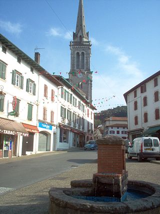
Arette is a commune in the Pyrénées-Atlantiques department in the Nouvelle-Aquitaine region of southwestern France. It is located in the arrondissement of Oloron-Sainte-Marie and the canton of Oloron-Sainte-Marie-1.

Araux is a commune in the Pyrénées-Atlantiques department in southwestern France.

<span class="mw-page-title-main">Agnos</span> Commune in Nouvelle-Aquitaine, France

Agnos is a commune in the Pyrénées-Atlantiques department in the Nouvelle-Aquitaine region in southwestern France. Agnos is part of the urban area of Oloron-Sainte-Marie.

<span class="mw-page-title-main">Moulins-sur-Orne</span> Commune in Normandy, France

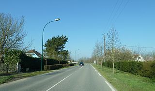
Moulins-sur-Orne is a commune in the Orne department in north-western France.

<span class="mw-page-title-main">Occagnes</span> Commune in Normandy, France

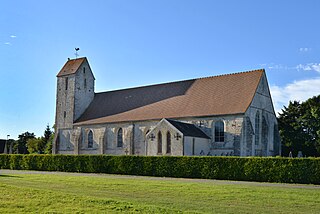
Occagnes is a commune in the Orne department in north-western France.

<span class="mw-page-title-main">Géronce</span> Commune in Nouvelle-Aquitaine, France

Géronce is a commune in the Pyrénées-Atlantiques department in south-western France.

<span class="mw-page-title-main">Sarpourenx</span> Commune in Nouvelle-Aquitaine, France

Sarpourenx is a commune in the Pyrénées-Atlantiques department in south-western France, notable for once having forbidden death by mayoral decree.

<span class="mw-page-title-main">Ossau Valley</span>

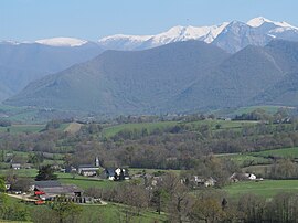
The Ossau Valley is a valley of the French Pyrénées, in the Pyrénées-Atlantiques département.

<span class="mw-page-title-main">Ourse</span> River in France

The Ourse, or Ourse de Ferrère, is a French river in the Pyrenees, a tributary of the Garonne. It is 25.4 km (15.8 mi) long. It forms the Barousse valley.

<span class="mw-page-title-main">Falleron (river)</span> French coastal river

The Falleron is a French coastal river forming the boundary between the departments of Vendée and Loire-Atlantique and flowing into the Bay of Biscay and Atlantic Ocean via the Bay of Bourgneuf.

<span class="mw-page-title-main">Abatesco</span> River of the Haute-Corse department in Corsica

The Abatesco is a French coastal river which flows through the Haute-Corse department and empties into the Tyrrhenian Sea.

References

  1. 1 2 "Répertoire national des élus: les maires" (in French). data.gouv.fr, Plateforme ouverte des données publiques françaises. 13 September 2022.
  2. "Populations légales 2021" (in French). The National Institute of Statistics and Economic Studies. 28 December 2023.
  3. Sandre. "Fiche cours d'eau - Le Landistou (Q5010550)".
  4. Sandre. "Fiche cours d'eau - Le Luz (Q5030500)".
  5. Sandre. "Fiche cours d'eau - Ruisseau de la Fontaine de Mesplé (Q5000730)".
  6. 1 2 Des villages de Cassini aux communes d'aujourd'hui: Commune data sheet Lys, EHESS (in French).
  7. Population en historique depuis 1968, INSEE