
Saltwater River is a former penal colony on the Tasman Peninsula in Tasmania, Australia. It is 23 kilometres (14 mi) from Port Arthur, and 106 kilometres (66 mi) from Hobart. At the 2006 census, Saltwater River had a population of 156.
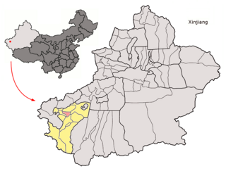
Yopurga County is a county in the southwest of the Xinjiang Uyghur Autonomous Region and is under the administration of the Kashgar Prefecture. It contains an area of 3,126 km2 (1,207 sq mi). According to the 2002 census, it has a population of 130,000.
Serdica is a district located in the center of the capital Sofia. It includes four neighbourhoods: "Fondovi zhilishta"; "Banishora", "Orlandovtsi" and "Malashevtsi" as well as the central parts of "Draz mahala". It has an area of 17.53 km² that counts for 1,3% of the total Capital Municipality area and 8,8% of the city proper. As of 2006 Serdica has a population of 52,918.

Dębniki is a village in the administrative district of Gmina Strzelin, within Strzelin County, Lower Silesian Voivodeship, in south-western Poland. Prior to 1945 it was in Germany.
Stare Młodochowo is a village in the administrative district of Gmina Raciąż, within Płońsk County, Masovian Voivodeship, in east-central Poland. It lies approximately 8 kilometres (5 mi) south-west of Raciąż, 24 km (15 mi) north-west of Płońsk, and 85 km (53 mi) north-west of Warsaw.
Majdany-Leśniczówka is a settlement in the administrative district of Gmina Lubowidz, within Żuromin County, Masovian Voivodeship, in east-central Poland.
Kobierno is a village in the administrative district of Gmina Krotoszyn, within Krotoszyn County, Greater Poland Voivodeship, in west-central Poland. It lies approximately 6 kilometres (4 mi) north-east of Krotoszyn and 85 km (53 mi) south-east of the regional capital Poznań.
Sierniki is a village in the administrative district of Gmina Rogoźno, within Oborniki County, Greater Poland Voivodeship, in west-central Poland. It lies approximately 6 kilometres (4 mi) east of Rogoźno, 21 km (13 mi) north-east of Oborniki, and 40 km (25 mi) north of the regional capital Poznań. The village has a population of 280.
Zajączki Pierwsze is a village in the administrative district of Gmina Krzepice, within Kłobuck County, Silesian Voivodeship, in southern Poland. It lies approximately 4 kilometres (2 mi) north of Krzepice, 18 km (11 mi) north-west of Kłobuck, and 86 km (53 mi) north of the regional capital Katowice.

Gnojna is a village in the administrative district of Gmina Grodków, within Brzeg County, Opole Voivodeship, in south-western Poland. It lies approximately 7 kilometres (4 mi) north-west of Grodków, 21 km (13 mi) south-west of Brzeg, and 46 km (29 mi) west of the regional capital Opole.

Nowy Browiniec is a village in the administrative district of Gmina Lubrza, within Prudnik County, Opole Voivodeship, in south-western Poland, close to the Czech border. It lies approximately 9 kilometres (6 mi) east of Lubrza, 12 km (7 mi) east of Prudnik, and 39 km (24 mi) south of the regional capital Opole.
Powałki is a village in the administrative district of Gmina Chojnice, within Chojnice County, Pomeranian Voivodeship, in northern Poland. It lies approximately 7 kilometres (4 mi) north-east of Chojnice and 97 km (60 mi) south-west of the regional capital Gdańsk.
Dankowo is a village in the administrative district of Gmina Kwidzyn, within Kwidzyn County, Pomeranian Voivodeship, in northern Poland. It lies approximately 3 kilometres (2 mi) south-east of Kwidzyn and 75 km (47 mi) south of the regional capital Gdańsk.
Stańkowo is a village in the administrative district of Gmina Prabuty, within Kwidzyn County, Pomeranian Voivodeship, in northern Poland. It lies approximately 5 kilometres (3 mi) south-east of Prabuty, 22 km (14 mi) east of Kwidzyn, and 81 km (50 mi) south-east of the regional capital Gdańsk.
Kulmaga is a village in the administrative district of Gmina Smętowo Graniczne, within Starogard County, Pomeranian Voivodeship, in northern Poland. It lies approximately 3 kilometres (2 mi) east of Smętowo Graniczne, 29 km (18 mi) south-east of Starogard Gdański, and 70 km (43 mi) south of the regional capital Gdańsk.
Bulows Minde is a settlement on the island of Saint Croix in the United States Virgin Islands.
Coble is a settlement on the island of Saint Croix in the United States Virgin Islands.
Grange is a settlement on the island of Saint Croix in the United States Virgin Islands.

Bristow is an unincorporated community in Clark Township, Perry County, in the U.S. state of Indiana.
Selig is an unincorporated community in Adams County, in the U.S. state of Ohio.


