
Marshall County is a county located on the north central border of the U.S. state of Mississippi. As of the 2020 census, the population was 33,752. Its county seat is Holly Springs. The county is named for Chief Justice of the United States John Marshall, who presided in the early nineteenth century.

Lafayette County is a county in the U.S. state of Mississippi. At the 2020 census, the population was 55,813. Its county seat is Oxford. The local pronunciation of the name is "la-FAY-et." The county's name honors Marquis de Lafayette, a French military hero and American general who fought during the American Revolutionary War.

Byhalia, is a town in Marshall County, Mississippi, United States. The population was 1,339 as of the 2020 census.
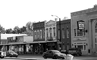
Holly Springs is a city in, and the county seat of, Marshall County, Mississippi, United States, near the border with Tennessee to the north. Along with the Mississippi Delta, in the 19th century, the area was developed by European Americans for cotton plantations. After the Civil War, many freedmen continued to work in agriculture as sharecroppers and tenant farmers.

Abram Marshall Scott was a National Republican Mississippi politician born in Edgefield County in the Province of South Carolina. He was an early settler of Wilkinson County, Mississippi and was instrumental in founding the town of Woodville, Mississippi. He held local political offices before his election to the Mississippi State Senate.

Walter Daniel Leake was a judge, U.S. senator, and governor of Mississippi. He served as a United States Senator from Mississippi (1817–1820), as a justice in 1821, and as third Governor of Mississippi (1822–1825). He was the first Governor of Mississippi to die in office.

Little Dixie is a historic 13- to 17-county region along the Missouri River in central Missouri, United States. Its early Anglo-American settlers were largely migrants from the hemp and tobacco districts of Virginia, Kentucky, and Tennessee. They brought enslaved African Americans with them or purchased them as workers in the region. Because Southerners settled there first, the pre-Civil War culture of the region was similar to that of the Upper South. The area was also known as Boonslick country.
Chulahoma is an unincorporated community in Marshall County, Mississippi, United States. It is located in the hill country of northern Mississippi.
Hudsonville,, is an unincorporated community in Marshall County, Mississippi, United States. It is located in the hill country of north Mississippi.
Lamar is a census-designated place and unincorporated community in Benton County, Mississippi, United States. It is located along Mississippi Highway 7 in western Benton County. Lamar has a post office with the ZIP code 38642. The nearly abandoned Mississippi Central Railroad runs through Lamar, and is only used rarely for freight trafficking. Lamar shares its ZIP code with the nearby community of Slayden.
Slayden is an unincorporated community in Marshall County, Mississippi, United States. It is located along U.S. Route 72 in northeast Marshall County, about 35 miles from Memphis, Tennessee.
Cayce, is an unincorporated community in Marshall County, Mississippi, United States.
Una is an unincorporated community in Clay County, Mississippi, United States.
Early Grove is an unincorporated community located in Marshall County, Mississippi, United States, near the Mississippi/Tennessee border. Early Grove is approximately 11 miles (18 km) west of Michigan City, approximately 10 miles (16 km) east of Mount Pleasant and approximately 20 miles (32 km) southeast of Collierville, north of U.S. Route 72.
Barton is an unincorporated community in western Marshall County, Mississippi, United States. It is located at the intersection of State Highway 302 and State Highway 309. A post office operated under the name Barton from 1884 to 1905. In 1900, Barton had a population of 45.
Mount Pleasant is a census-designated place and unincorporated community in northeastern Marshall County, Mississippi, United States, located along U.S. Route 72 at State Route 311. Although unincorporated, it has a post office serving the nearby city of Holly Springs. The zip code is 38649. The community also has a volunteer fire department located on Boswell Road, and a K-12 school located off of US Highway 72. Mount Pleasant is bordered by Cayce and Taska to the west, Holly Springs to the south, Slayden to the east, and Collierville, Tennessee to the north.
Red Banks is a census-designated place and unincorporated community located in Marshall County, Mississippi, United States.

Good Hope is an unincorporated community in Holmes County, Mississippi, United States. Good Hope is located on U.S. Route 49E, 7.2 miles (11.6 km) southwest of Tchula.
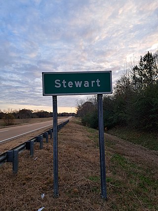
Stewart is a census-designated place and unincorporated community in Montgomery County, Mississippi, United States.
Williamsburg,, is an Unincorporated community in Covington County, Mississippi, United States. Williamsburg served as the county seat from 1829 until 1906. Three separate courthouses were built and subsequently burned in Williamsburg. The last courthouse was burned by an arsonist. Train service was brought to an area nearby named Williamsburg Depot, which was renamed Collins. Williamsburg lost its status as a county seat and was replaced by Collins.


