Victoria, Marshall County, Mississippi

Last updated

Victoria, Mississippi
USA Mississippi location map.svg
Red pog.svg
Victoria
Usa edcp location map.svg
Red pog.svg
Victoria
Coordinates: 34°50′46″N89°37′05″W / 34.84611°N 89.61806°W / 34.84611; -89.61806
Country United States
State Mississippi
County Marshall
Area
[1]
  Total7.37 sq mi (19.08 km2)
  Land7.36 sq mi (19.05 km2)
  Water0.01 sq mi (0.03 km2)
Elevation
410 ft (120 m)
Population
 (2020) [2]
  Total1,066
  Density144.92/sq mi (55.96/km2)
Time zone UTC-6 (Central (CST))
  Summer (DST) UTC-5 (CDT)
ZIP codes
38679 (PO box)
38611 (Byhalia)
38661 (Red Banks)
Area code 662
GNIS feature ID679219 [3]
FIPS code 28-76760

Victoria is a census-designated place and unincorporated community in Marshall County, Mississippi, United States. [3] It was first listed as a CDP in the 2020 census, which recorded a population of 1,066. [2]

Contents

History

Victoria is located on the BNSF Railway and was established on January 22, 1886. [4] In 1900, Victoria had a population of 30, a church, and cotton gin. [5]

In 1925, the Sunnyland passenger train derailed and tumbled down an embankment as it approached Victoria, killing 20. [6]

Geography

Victoria is in northwestern Marshall County. Mississippi Highway 178 passes through the community, leading northwest 4 miles (6 km) to Byhalia and southeast 11 miles (18 km) to Holly Springs, the county seat. Interstate 22 passes through the south side of Victoria, with access from Exit 18 (Victoria Road). I-22 leads southeast 70 miles (110 km) to Tupelo and northwest to the Memphis, Tennessee, area. Downtown Memphis is 35 miles (56 km) northwest of Victoria.

According to the U.S. Census Bureau, the Victoria CDP has a total area of 7.37 square miles (19.09 km2), of which 0.01 square miles (0.03 km2), or 0.16%, are water. [1] Barrow Creek passes through the south side of the community, flowing northwest toward Byhalia Creek, a tributary of the Coldwater River and part of the Tallahatchie River watershed.

Demographics

Historical population
CensusPop.Note
2020 1,066
U.S. Decennial Census [7]
2020 [8]

2020 census

Victoria CDP, Mississippi - Demographic Profile
(NH = Non-Hispanic)
Race / EthnicityPop 2020 [8] % 2020
White alone (NH)67162.95%
Black or African American alone (NH)23922.42%
Native American or Alaska Native alone (NH)30.28%
Asian alone (NH)00.00%
Pacific Islander alone (NH)00.00%
Some Other Race alone (NH)20.19%
Mixed Race/Multi-Racial (NH)444.13%
Hispanic or Latino (any race)10710.04%
Total1,066100.00%

Note: the US Census treats Hispanic/Latino as an ethnic category. This table excludes Latinos from the racial categories and assigns them to a separate category. Hispanics/Latinos can be of any race.

Related Research Articles

<span class="mw-page-title-main">Helena, Mississippi</span> Census-designated place in Mississippi, United States

Helena is an unincorporated community and census-designated place (CDP) in Jackson County, Mississippi, United States. It is part of the Moss Point Metropolitan Statistical Area. Per the 2020 Census, the population was 983.

<span class="mw-page-title-main">Byhalia, Mississippi</span> Town in Mississippi, United States

Byhalia, is a town in Marshall County, Mississippi, United States. The population was 1,339 as of the 2020 census.

Kokomo is a census-designated place and unincorporated community in Marion County, Mississippi, United States. As of the 2020 census, the first year it was listed as a census-designated place, it had a population of 150.

Eudora is a census-designated place and unincorporated community located in southwestern DeSoto County, Mississippi, United States, approximately 25 miles (40 km) south of Memphis, Tennessee. The intersection of Mississippi Highway 301 and old Mississippi Highway 304 has been the traditional heart of Eudora for decades.

<span class="mw-page-title-main">Farrell, Mississippi</span> Census-designated place in Mississippi, United States

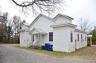
Farrell is an unincorporated community and census-designated place in Coahoma County, Mississippi, United States. Per the 2020 census, the population was 200. Farrell is located approximately 4 miles (6 km) south of Stovall and 4 miles (6 km) north of Sherard on Mississippi Highway 1. It is approximately 9 miles (14 km) northwest of Clarksdale, the county seat.

Lake View is a census-designated place and unincorporated community located in DeSoto County, Mississippi, United States, near the Mississippi/Tennessee border just south of Memphis and north of the village of Walls. Lake View is located on the former Yazoo and Mississippi Valley Railroad.

<span class="mw-page-title-main">White Oak, Mississippi</span> CDP in Mississippi, United States

White Oak is a census-designated place located on Mississippi Highway 4 in Tunica County, Mississippi. White Oak is approximately 2 miles (3.2 km) east of Evansville and approximately 8 miles (13 km) west of Savage. The population at the 2020 census was 692.

<span class="mw-page-title-main">Dennis, Mississippi</span> Census-designated place in Mississippi, United States

Dennis is a census-designated place and unincorporated community located at the intersection of Mississippi Highway 25 and Mississippi Highway 4 in Tishomingo County, Mississippi, United States. Dennis is approximately 6 miles (9.7 km) south of Tishomingo and 3 miles (4.8 km) north of Belmont.

<span class="mw-page-title-main">Waterford, Mississippi</span> Census-designated place in Mississippi, United States

Waterford is a census-designated place and unincorporated community in Marshall County, Mississippi, United States. It is a small town located between Holly Springs and Oxford on Highway 7.

Mount Pleasant is a census-designated place and unincorporated community in Marshall County, Mississippi, United States, located along U.S. Highway 72 at State Highway 311. The community has a volunteer fire department on Boswell Road, and a K-12 school located off Highway 72.

Red Banks is a census-designated place and unincorporated community in Marshall County, Mississippi, United States. It was first listed as a CDP in the 2020 census, which reported a population of 215.

Paris is a census-designated place and unincorporated community in Lafayette County, Mississippi, United States. Paris is located at the junction of Mississippi Highway 9W and Mississippi Highway 315 10 miles (16 km) east of Water Valley.

<span class="mw-page-title-main">Stewart, Mississippi</span> Census-designated place in Mississippi, United States

Stewart is a census-designated place and unincorporated community in Montgomery County, Mississippi, United States.

Morgantown is a census-designated place (CDP) in Adams County, Mississippi, United States, located to the northeast of the city of Natchez. As of the 2020 census, it had a population of 1,334.

Cloverdale is a census-designated place (CDP) in Adams County, Mississippi, United States, located to the south of the city of Natchez. As of the 2020 census, it had a population of 557.

Bethlehem is a census-designated place and unincorporated community in Marshall County, Mississippi, United States. Its ZIP code is 38659.

Cleary is an unincorporated community and census-designated place in Rankin County, Mississippi, United States. Per the 2020 census, the population was 1,688.

Robinhood is an unincorporated community and census-designated place in Rankin County, Mississippi, United States. Per the 2020 census, the population was 1,491.

Live Oak is an unincorporated community and census-designated place (CDP) in Horry County, South Carolina, United States. As of the 2020 census it had a population of 93.

Ben Avon is an unincorporated area and census-designated place (CDP) adjacent to the city of Spartanburg in Spartanburg County, South Carolina, United States. It was first listed as a CDP prior to the 2020 census. The population as of 2020 was 2,428.

References

  1. 1 2 "2023 U.S. Gazetteer Files: Mississippi". United States Census Bureau. Retrieved March 7, 2024.
  2. 1 2 "P1. Race – Victoria CDP, Mississippi: 2020 DEC Redistricting Data (PL 94-171)". U.S. Census Bureau. Retrieved March 7, 2024.
  3. 1 2 "Victoria, Mississippi". Geographic Names Information System . United States Geological Survey, United States Department of the Interior.
  4. Howe, Tony. "Victoria, Mississippi". Mississippi Rails. Retrieved June 9, 2023.
  5. Rowland, Dunbar (1907). Mississippi: Comprising Sketches of Counties, Towns, Events, Institutions, and Persons, Arranged in Cyclopedic Form (PDF). Vol. 2. Southern Historical Publishing Association. p. 886.
  6. "Twenty Killed in Train Wreck". Evening Independent. October 27, 1925.
  7. "Decennial Census of Population and Housing by Decades". US Census Bureau.
  8. 1 2 "P2 HISPANIC OR LATINO, AND NOT HISPANIC OR LATINO BY RACE - 2020: DEC Redistricting Data (PL 94-171) - Victoria CDP, Mississippi". United States Census Bureau .