
Tipton County is a county located on the western end of the U.S. state of Tennessee, in the Mississippi Delta region. As of the 2020 census, the population was 60,970. Its county seat is Covington. Tipton County, founded in 1823, is part of the Memphis, TN-MS-AR Metropolitan Statistical Area.

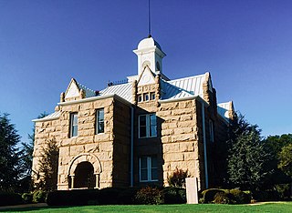
Marshall County is a county located on the north central border of the U.S. state of Mississippi. As of the 2020 census, the population was 33,752. Its county seat is Holly Springs. The county is named for Chief Justice of the United States John Marshall, who presided in the early nineteenth century.

DeSoto County is a county located on the northwestern border of the U.S. state of Mississippi. As of the 2020 census, the population was 185,314, making it the third-most populous county in Mississippi. Its county seat is Hernando.

Houston is a city and one of two county seats of Chickasaw County, in northeastern Mississippi, United States. The population was 3,623 at the 2010 census.

Oxford is the 14th most populous city in Mississippi, and the county seat of Lafayette County, 75 miles (121 km) southeast of Memphis. A college town, the University of Mississippi or "Ole Miss" is adjacent to the city. Founded in 1837, it is named for Oxford, England.
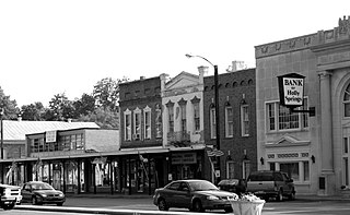
Holly Springs is a city in, and the county seat of, Marshall County, Mississippi, United States, near the border with Tennessee to the north. Along with the Mississippi Delta, in the 19th century, the area was developed by European Americans for cotton plantations. After the Civil War, many freedmen continued to work in agriculture as sharecroppers and tenant farmers.
Tishomingo is the largest city in, and the county seat of, Johnston County, Oklahoma, United States. The population was 3,034 at the 2010 census, a decline of 4.1 percent from the figure of 3,162 in 2000. It was the first capital of the Chickasaw Nation, from 1856 until Oklahoma statehood in 1907. The city is home to Murray State College, a community college with an annual enrollment of 3,015 students. Tishomingo is part of the Texoma region.
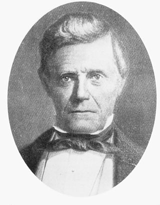
Joseph Warren Matthews was an American politician who served as Governor of Mississippi from 1848 to 1850.

The Natchez Trace Parkway is a national parkway in the Southeastern United States that commemorates the historic Natchez Trace and preserves sections of that original trail. Its central feature is a two-lane road that extends 444 miles (715 km) from Natchez, Mississippi, to Nashville, Tennessee. Access to the parkway is limited, with more than 50 access points in Mississippi, Alabama, and Tennessee. The southern end of the route is in Natchez at its intersection with Liberty Road, and the northern end is northeast of Fairview, Tennessee, in the suburban community of Pasquo, at an intersection with Tennessee State Route 100. In addition to Natchez and Nashville, larger cities along the route include Jackson and Tupelo, Mississippi, and Florence, Alabama.

The Wolf River is a 105-mile-long (169 km) alluvial river in western Tennessee and northern Mississippi, whose confluence with the Mississippi River was the site of various Chickasaw, French, Spanish and American communities that eventually became Memphis, Tennessee. It is estimated to be about 12,000 years old, formed by Midwestern glacier runoff carving into the region's soft alluvial soil. It should not be confused with The Wolf River which flows primarily in Middle Tennessee and southern Kentucky. The Wolf River rises in the Holly Springs National Forest at Baker's Pond in Benton County, Mississippi, and flows northwest into Tennessee, before entering the Mississippi River north of downtown Memphis.

Tishomingo State Park is a public recreation area located in the foothills of the Appalachian Mountains in Tishomingo County, some 45 miles (72 km) northeast of Tupelo, Mississippi. The major feature of the park is Bear Creek Canyon and its generous sandstone outcroppings. Activities in the park include canoeing, rock climbing, fishing, and hiking. The park sits at Milepost 304 of Natchez Trace Parkway, a scenic road operated by the National Park Service that runs directly through the park.

The Holly Springs National Forest (HSNF) was established by the United States Forest Service on June 15, 1936, during the tenure of United States Department of Agriculture Chief Forester Ferdinand A. Silcox. That same year, it was combined administratively with the Bienville, De Soto and Homochitto national forests, known collectively as "National Forests in Mississippi". The Holly Springs Ranger District controls 155,661 acres (243.2 sq mi) of Forest Service land, interspersed with 530,000 acres (828.1 sq mi) of privately owned properties, within the national forest's proclamation zone.
The Wolf River Conservancy (WRC) is a non-profit 501(c)(3) organization whose stated purpose is "conserving and enhancing the Wolf River and its environs as a natural resource for public education and low-impact recreational activities." Headquartered in Memphis, Tennessee. It has approximately 1,500 members from throughout West Tennessee, led by an active Board of Directors and staff and advised by the Wolf River Conservancy Trustees. It is a fully accredited member of The Land Trust Alliance.
Chulahoma is an unincorporated community in Marshall County, Mississippi, United States. It is located in the hill country of northern Mississippi.

David "Junior" Kimbrough was an American blues musician. His best-known works are "Keep Your Hands off Her" and "All Night Long". In 2023, he was inducted in the Blues Hall of Fame.

Mississippi Highway 7 runs generally north–south from the Tennessee state line in Benton County to Belzoni, Mississippi. It travels approximately 168 miles (270 km), serving Humphreys, Leflore, Carroll, Grenada, Yalobusha, Lafayette, Marshall, and Benton counties while serving several points of interest, including Florewood River Plantation State Park, the University of Mississippi, and Wall Doxey State Park. MS 7 runs nearly parallel to the rarely used Mississippi Central Railroad.

Wall Doxey State Park is a public recreation area located off Mississippi Highway 7, seven miles (11 km) south of Holly Springs, Mississippi. The state park is centered on 60-acre (24 ha) Spring Lake.
Early Grove is an unincorporated community located in Marshall County, Mississippi, United States, near the Mississippi/Tennessee border. Early Grove is approximately 11 miles (18 km) west of Michigan City, approximately 10 miles (16 km) east of Mount Pleasant and approximately 20 miles (32 km) southeast of Collierville, north of U.S. Route 72.
Hill country blues is a regional style of country blues. It is characterized by a strong emphasis on rhythm and percussion, steady guitar riffs, few chord changes, unconventional song structures, and heavy emphasis on the "groove", which has been characterized as the "hypnotic boogie".

Waterford is a census-designated place and unincorporated community located in Marshall County, Mississippi, United States. It is a small town located between Holly Springs and Oxford on Highway 7.


