
New Zealand is an island country located in the south-western Pacific Ocean, near the centre of the water hemisphere. It consists of a large number of islands, estimated around 600, mainly remnants of a larger land mass now beneath the sea. The two main islands by size are the North Island and the South Island, separated by the Cook Strait; the third-largest is Stewart Island, located 30 kilometres off the tip of the South Island across Foveaux Strait. The three largest islands stretch 1,500 kilometres across latitudes 34° to 47° south. It is the sixth-largest island country in the world with a land size of 267,710 km2 (103,360 sq mi).
Te Kooti Arikirangi Te Turuki was a Māori leader, the founder of the Ringatū religion and guerrilla fighter.
The Chatham Standard Time Zone is a geographic region that keeps time by adding twelve hours and forty-five minutes to Coordinated Universal Time (UTC) resulting in UTC+12:45.
The New Zealand raven was native to the North Island and South Island of New Zealand but has been extinct since the 16th century. There were two subspecies: the North Island raven and the South Island raven. Another closely related species, the Chatham raven, occurred on the Chatham Islands.

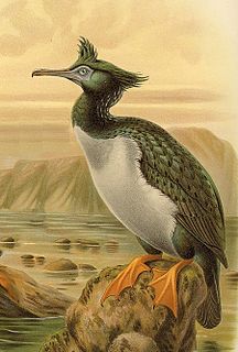
The Chatham raven is an extinct raven formerly native to the Chatham Islands. The closely related New Zealand raven, C. antipodum occurred in the North and South Islands of New Zealand. C. antipodum was formerly included in C. moriorum, and later considered a distinct species, however in 2017 genetic researchers determined that the two raven populations were subspecies rather than separate species.
Cape Pattisson is a headland in the northwest of Chatham Island, the largest island in the Chatham Islands chain, located 800 km east of New Zealand's South Island.
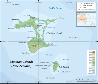
The Sisters, or Rangitatahi in Maori, is a group of three islands located 16 kilometres (10 mi) north of Cape Pattison, Chatham Island. They are the northernmost members of the Chatham Archipelago, located 800 kilometres (497 mi) east of New Zealand's South Island.

Petre Bay is a large bay which comprises about half of the west coast of Chatham Island, the largest island in New Zealand's Chatham Islands archipelago. It is some 20 kilometres (12 mi) in extent, and contains the far smaller Waitangi Bay, where the island group's largest settlement, Waitangi is located.
Hanson Bay is a large bay which comprises almost the entire east coast of Chatham Island, the largest island in New Zealand's Chatham Islands archipelago. It is 35 kilometres (22 mi) in extent, stretching from Okawa Point in the island's northeast to Manukau Point in the southeast. The bay may formerly have been used as a resting ground by southern right whales and dolphins.

Ngāti Mutunga is a Māori iwi (tribe) of New Zealand, whose original rohe were in north Taranaki. They migrated from Taranaki, first to Wellington, and then to the Chatham Islands in the 1830s. The rohe of the iwi includes Wharekauri, Te Whanga Lagoon and Waitangi on Chatham Island, and Pitt Island, also part of the Chatham Islands. The principal marae are at Urenui in Taranaki, and the Chatham Islands.
Owenga is a small settlement on Chatham Island, in New Zealand's Chatham Islands group. It is the second easternmost settlement in New Zealand, after Flower Pot Bay on Pitt Island. It is located in the southeast of the island, close to Cape Fournier.
The Tuku Nature Reserve is a nature reserve on Chatham Island, New Zealand, in the Tuku-a-tamatea (Tuku) River Valley in the south-west of the island. The 1238 hectares of land, largely covered with dense native forest, are owned by the New Zealand government and is managed by its Department of Conservation.
The Chatham tomtit is a subspecies of tomtit found on some of the smaller islands of New Zealand. It is most similar in plumage to the South Island tomtit, the nominate subspecies. The New Zealand government is implementing a plan to help this species and other bird species recover. The holotype is in the collection of the Museum of New Zealand Te Papa Tongarewa.
The Nairn River, also known as the Mangatukurewa Creek is a river in the Chatham Islands of New Zealand. Located in the southwest of Chatham Island, it runs north to reach the coast close to the southern end of Petre Bay. The main settlement of the Chatham Islands, Waitangi, stands close to the mouth of the Nairn River.
Okawa Point lies at the north-eastern end of Hanson Bay near the easternmost point of the main Chatham Island in the Chatham Islands group of New Zealand. It has been identified as an Important Bird Area by BirdLife International because it supports breeding colonies of the critically endangered Chatham and endangered Pitt shags.
Matarakau Point is a headland on the north coast, and 13 km from the easternmost point, of the main Chatham Island in the Chatham Islands group of New Zealand. It has been identified as an Important Bird Area by BirdLife International because it supports breeding colonies of the critically endangered Chatham and endangered Pitt shags.
Port Hutt is a small settlement on Chatham Island, in New Zealand's Chatham Islands chain. It is located in the northwest of the island, near the northern end of the large indentation of Petre Bay, some 24km from the island's largest settlement Waitangi.


