
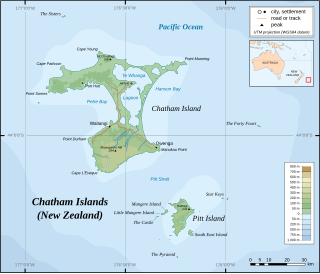
The Chatham Islands, are a part of New Zealand, and form an archipelago in the Pacific Ocean about 800 kilometres (500 mi) east of the South Island. The archipelago consists of about ten islands within an approximate 60-kilometre (37 mi) radius, the largest of which are Chatham Island and Pitt Island. They include New Zealand's easternmost point, the Forty-Fours. Some of the islands, formerly cleared for farming, are now preserved as nature reserves to conserve some of the unique flora and fauna.
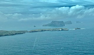
The Pyramid (Tarakoikoia) is a small island south of Pitt Island in the Chatham Islands group of New Zealand. The site has been identified as an Important Bird Area by BirdLife International because it supports the only known breeding colony of Chatham albatrosses, with 4575 pairs recorded in 2001.
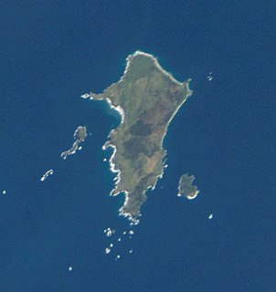
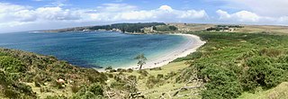
Pitt Island is the second largest island in the Chatham Archipelago, New Zealand. It is called Rangiauria in Māori and Rangiaotea in Moriori.
The Chatham Standard Time Zone is a geographic region that keeps time by adding twelve hours and forty-five minutes to Coordinated Universal Time (UTC) resulting in UTC+12:45.
Mangere Island is part of the Chatham Islands archipelago, located about 800 kilometres (500 mi) east of New Zealand's South Island and has an area of 113 hectares. The island lies off the west coast of Pitt Island, 45 kilometres (28 mi) south-east of the main settlement in the Chathams, Waitangi, on Chatham Island.
Rangatira or South East Island is the third largest island in the Chatham Islands archipelago, and covers an area of 218 hectares. It lies 800 kilometres (497 mi) east of New Zealand's South Island off the south-east coast of Pitt Island, 55 kilometres (34 mi) south-east of the main settlement, Waitangi, on Chatham Island.
Cape Pattisson is a headland in the northwest of Chatham Island, the largest island in the Chatham Islands chain, located 800 km east of New Zealand's South Island.
The Sisters, or Rangitatahi in Maori, is a group of three islands located 16 kilometres (10 mi) north of Cape Pattison, Chatham Island. They are the northernmost members of the Chatham Archipelago, located 800 kilometres (497 mi) east of New Zealand's South Island.
The Star Keys are group of five rocky islets in the Chatham Archipelago, about 12 kilometres (7 mi) east of Pitt Island They are called Motuhope in Moriori and Māori. The archipelago is part of New Zealand, whose South Island lies 800 kilometres (497 mi) to the west.
Little Mangere is a small island of the Chatham Archipelago, just off the western end of Mangere Island, about 4 km west of Pitt Island and 45 kilometres (28 mi) south-east of the town of Waitangi on Chatham Island. The island is called Tapuaenuku in Moriori and Māori, and was formerly called The Fort. The archipelago is part of New Zealand and is located about 800 kilometres (500 mi) to the east of the South Island.

Hanson Bay is a large bay which comprises almost the entire east coast of Chatham Island, the largest island in New Zealand's Chatham Islands archipelago. It is 35 kilometres (22 mi) in extent, stretching from Okawa Point in the island's northeast to Manukau Point in the southeast. The bay may formerly have been used as a resting ground by southern right whales and dolphins.

JM Barker (Hapupu) National Historic Reserve was created to protect 33 hectares of kopi forest containing Moriori tree carvings called momori-rakau.
Pitt Strait is a channel, 25 kilometres (16 mi) wide, separating Chatham Island and Pitt Island, the two largest islands in New Zealand's Chatham Islands.
Owenga is a small settlement on Chatham Island, in New Zealand's Chatham Islands group. It is the second easternmost settlement in New Zealand, after Flower Pot Bay on Pitt Island. It is located in the southeast of the island, close to Cape Fournier.
The Tuku Nature Reserve is a nature reserve on Chatham Island, New Zealand, in the Tuku-a-tamatea (Tuku) River Valley in the south-west of the island. The 1238 hectares of land, largely covered with dense native forest, are owned by the New Zealand government and is managed by its Department of Conservation.

Graovo Rocks is the group of rocks off the north coast of Robert Island in the South Shetland Islands, Antarctica, situated east of Lientur Rocks and southwest of Liberty Rocks, and extending 1.75 km (1.09 mi) in north-south direction and 750 m (820 yd) in east-west direction.
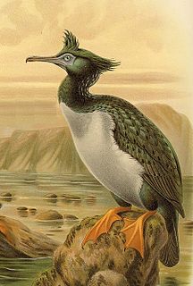
Okawa Point lies at the north-eastern end of Hanson Bay near the easternmost point of the main Chatham Island in the Chatham Islands group of New Zealand. It has been identified as an Important Bird Area by BirdLife International because it supports breeding colonies of the critically endangered Chatham and endangered Pitt shags.
Matarakau Point is a headland on the north coast, and 13 km from the easternmost point, of the main Chatham Island in the Chatham Islands group of New Zealand. It has been identified as an Important Bird Area by BirdLife International because it supports breeding colonies of the critically endangered Chatham and endangered Pitt shags.
Rabbit Island is a rocky islet lying off Tarawhenua Point on the north-west coast of Pitt Island in the Chatham Islands group of New Zealand. About 300 m long by 200 m across, its highest point is 44 m above sea level. It has been identified as an Important Bird Area by BirdLife International because it supports breeding colonies of the critically endangered Chatham and endangered Pitt shags.
Port Hutt is a small settlement on Chatham Island, in New Zealand's Chatham Islands chain. It is located in the northwest of the island, near the northern end of the large indentation of Petre Bay, some 24km from the island's largest settlement Waitangi.

