Cape Cod is a geographic cape extending into the Atlantic Ocean from the southeastern corner of mainland Massachusetts, in the northeastern United States. Its historic, maritime character and ample beaches attract heavy tourism during the summer months. The name Cape Cod, coined in 1602 by Bartholomew Gosnold, is the ninth oldest English place-name in the U.S.

The Western Hemisphere is the half of Earth which lies west of the prime meridian and east of the antimeridian. The other half is called the Eastern Hemisphere. In geopolitical terms, the context in which the term is most often used, the Encyclopedia Britannica defines it as "North and South America and the surrounding waters. Longitudes 20°W and 160°E are often considered its boundaries." It may be used in a cultural or geopolitical sense as a synonym for the "New World".

Savannah is the oldest city in the U.S. state of Georgia and is the county seat of Chatham County. Established in 1733 on the Savannah River, the city of Savannah became the British colonial capital of the Province of Georgia and later the first state capital of Georgia. A strategic port city in the American Revolution and during the American Civil War, Savannah is today an industrial center and an important Atlantic seaport. It is Georgia's fifth-largest city, with a 2020 U.S. Census population of 147,780. The Savannah metropolitan area, Georgia's third-largest, had a 2020 population of 404,798.

Chatham County is located in the U.S. state of Georgia, on the state's Atlantic coast. The county seat and largest city is Savannah. One of the original counties of Georgia, Chatham County was created February 5, 1777, and is named after William Pitt, 1st Earl of Chatham.

Miramichi is the largest city in northern New Brunswick, Canada. It is situated at the mouth of the Miramichi River where it enters Miramichi Bay. The Miramichi Valley is the second longest valley in New Brunswick, after the Saint John River Valley.

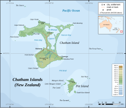
The Chatham Islands, part of New Zealand, form an archipelago in the Pacific Ocean about 800 kilometres (500 mi) east of the South Island. The archipelago consists of about ten islands within an approximate 60-kilometre (37 mi) radius, the largest of which are Chatham Island and Pitt Island. They include New Zealand's easternmost point, the Forty-Fours. Some of the islands, formerly cleared for farming, are now preserved as nature reserves to conserve some of the unique flora and fauna.

Chatham is a town in Barnstable County, Massachusetts, United States. Chatham is located at the southeast tip of Cape Cod, and has historically been a fishing community. First settled by the English in 1664, the township was originally called Monomoit based on the indigenous population's term for the region. Chatham was incorporated as a town on June 11, 1712, and has become a summer resort area. The population was 6,169 at the 2017 census, and can swell to 25,000 during the summer months. There are four villages that comprise the town, those being Chatham (CDC), South Chatham, North Chatham, and West Chatham. Chatham is home to the Monomoy National Wildlife Refuge, and the decommissioned Monomoy Point Light both located on Monomoy Island. A popular attraction is the Chatham Light, which is an operational lighthouse that is operated by the United States Coast Guard.

The Moriori are the native Polynesian people of the Chatham Islands, New Zealand. Moriori originated from Māori settlers from the New Zealand mainland around AD 1500. This was near the time of the shift from the archaic to classic Māori culture on the main islands of New Zealand. Oral tradition records multiple waves of migration to the Chatham Islands, starting in the 16th century. Over several centuries these settlers' culture diverged from mainland Māori, developing a distinctive language, mythology, artistic expression and way of life. Currently there are around 700 people who identify as Moriori, most of whom no longer live on the Chatham Islands. During the late 19th century some prominent anthropologists mistakenly proposed that Moriori were pre-Māori settlers of mainland New Zealand, and possibly Melanesian in origin.
Chatham Island is by far the largest island of the Chatham Islands group, in the south Pacific Ocean off the eastern coast of New Zealand's South Island. It is said to be "halfway between the equator and the pole, and right on the International Date Line", though the point in fact lies ca. 173 miles WSW of the island's westernmost point. The island is called Rekohu in Moriori, and Wharekauri in Māori.
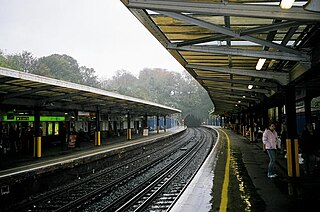
Chatham railway station is on the Chatham Main Line in England, serving the town of Chatham, Kent. It is 34 miles 25 chains (55.2 km) down the line from London Victoria and is situated between Rochester and Gillingham.
Kent was a federal electoral district (riding) represented in the House of Commons of Canada from 1867 to 1904, 1917 to 1968, and 1979 to 1997. It was located in the province of Ontario, and was created by the British North America Act of 1867.

Chatham Road South and Chatham Road North are two continuous roads spanning from Tsim Sha Tsui to Hung Hom in Kowloon, Hong Kong. The road originally ran from Signal Hill to Hung Hom under No. 12 Hill by the side of Hung Hom Bay. It was later extended through Lo Lung Hang to the southern end of To Kwa Wan, which makes up Chatham Road North.
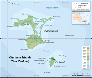
Mangere Island is part of the Chatham Islands archipelago, located about 800 kilometres (500 mi) east of New Zealand's South Island and has an area of 113 hectares. The island lies off the west coast of Pitt Island, 45 kilometres (28 mi) south-east of the main settlement in the Chathams, Waitangi, on Chatham Island.

The Sisters, or Rangitatahi in Māori, is a group of three islands located 16 kilometres (10 mi) north of Cape Pattison, Chatham Island. They are the northernmost members of the Chatham Archipelago, located 800 kilometres (497 mi) east of New Zealand's South Island.

The Forty-Fours are a group of islands in the Chatham Archipelago, about 50 kilometres (31 mi) east of the main Chatham Island. They are called Motchuhar in Moriori and Motuhara in Māori. The group includes the easternmost point of New Zealand, whose South Island is located about 800 kilometres (497 mi) to the west.
Little Mangere is a small island of the Chatham Archipelago, just off the western end of Mangere Island, about 4 km west of Pitt Island and 45 kilometres (28 mi) south-east of the town of Waitangi on Chatham Island. The island is called Tapuaenuku in Moriori and Māori, and was formerly called The Fort. The archipelago is part of New Zealand and is located about 800 kilometres (500 mi) to the east of the South Island.

The Chatham shag, also known as the Chatham Island shag, is a species of bird in the cormorant and shag family, Phalacrocoracidae. It is endemic to the Chatham Islands of New Zealand. For a long time the species was placed in the genus Phalacrocorax; today it is mostly placed with the other blue-eyed shags of New Zealand and Antarctica in the genus Leucocarbo. Its closest relative is the Otago shag of South Island.

Rangitahi Lake is located in the Chatham Islands of New Zealand. It is located on Chatham Island, to the northeast of Te Whanga Lagoon, close to the northern end of Hanson Bay.

Chatham Sound is a sound on the North Coast of British Columbia, Canada, bordering on Alaska, United States. It is located between the Dundas and Stephens Islands and the Tsimpsean Peninsula, it is part of the Inside Passage and extends from Portland Inlet in the north to Porcher Island in the south.

Call Inlet is an inlet on the Central Coast region of British Columbia, Canada, located south of the lower reaches of Knight Inlet to the east of East Cracroft Island. Pawala Indian Reserve No. 5 is at the head of the inlet. Chatham Channel connects the outlet of the inlet to Knight Inlet and separates East Cracroft Island from the mainland peninsula on the north side of the inlet. Havannah Channel leads southwest out of the inlet, south and east around East Cracroft and past Hull Island, to Johnstone Strait.