
The Auckland Islands are an archipelago of New Zealand, lying 465 km (289 mi) south of the South Island. The main Auckland Island, occupying 460 km2 (180 sq mi), is surrounded by smaller Adams Island, Enderby Island, Disappointment Island, Ewing Island, Rose Island, Dundas Island, and Green Island, with a combined area of 570 km2 (220 sq mi). The islands have no permanent human inhabitants.

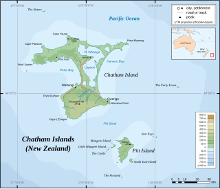
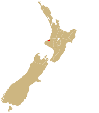
The Chatham Islands are an archipelago in the Pacific Ocean about 800 km (430 nmi) east of New Zealand's South Island, administered as part of New Zealand, and consisting of about 10 islands within an approximate 60 km (30 nmi) radius, the largest of which are Chatham Island and Pitt Island (Rangiauria). They include New Zealand's easternmost point, the Forty-Fours. Some of the islands, formerly cleared for farming, are now preserved as nature reserves to conserve some of the unique flora and fauna.

The Moriori are the first settlers of the Chatham Islands. Moriori are Polynesians who came from the New Zealand mainland around 1500 CE, which was close to the time of the shift from the archaic to the classic period of Polynesian Māori culture on the mainland. Oral tradition records migration to the Chathams in the 16th century. The settlers' culture diverged from mainland Māori, and they developed a distinct Moriori language, mythology, artistic expression and way of life. Currently there are around 700 people who identify as Moriori, most of whom no longer live on the Chatham Islands. During the late 19th century some prominent anthropologists proposed that Moriori were pre-Māori settlers of mainland New Zealand, and possibly Melanesian in origin.
Chatham Island is the largest island of the Chatham Islands group, in the south Pacific Ocean off the eastern coast of New Zealand's South Island. It is said to be "halfway between the equator and the pole, and right on the International Date Line", although that point is 173 miles WSW of the island's westernmost point. The island is called Rekohu in Moriori, and Wharekauri in Māori.

The magenta petrel, or Chatham Island tāiko, is a small seabird in the gadfly petrel genus, Pterodroma. Found exclusively on Chatham Island, New Zealand, it is one of the rarest birds in the world, believed to be extinct for over 100 years before its rediscovery in the 1970s.

The Chatham albatross, also known as the Chatham mollymawk or Chatham Island mollymawk, is a medium-sized black-and-white albatross which breeds only on The Pyramid, a large rock stack in the Chatham Islands, New Zealand (Aotearoa). It is sometimes treated as a subspecies of the shy albatross Thalassarche cauta. It is the smallest of the shy albatross group.

Karaka or New Zealand laurel is a medium-sized evergreen tree in the Corynocarpaceae family. It is endemic to New Zealand and is common throughout the North Island and less common in the South Island. Karaka are also found on the Chatham Islands, Kermadec Islands, and the Three Kings Islands. It is mostly a coastal tree, though in the North Island, it can also be found in lowland inland forests.
Mangere Island is part of the Chatham Islands archipelago, located about 800 kilometres (500 mi) east of New Zealand's South Island and has an area of 113 hectares. The island lies off the west coast of Pitt Island, 45 kilometres (28 mi) south-east of the main settlement in the Chathams, Waitangi, on Chatham Island.
Hokorereoro, Rangatira, or South East Island is the third largest island in the Chatham Islands archipelago, and covers an area of 218 hectares. It lies 800 kilometres (497 mi) east of New Zealand's South Island off the south-east coast of Pitt Island, 55 kilometres (34 mi) south-east of the main settlement, Waitangi, on Chatham Island.

The Sisters is a group of three main islands located 16 kilometres (10 mi) north of Cape Pattison, Chatham Island. They are the northernmost members of the Chatham Archipelago, located 800 kilometres (497 mi) east of New Zealand's South Island.
The Star Keys are group of five rocky islets in the Chatham Archipelago, about 12 kilometres (7 mi) east of Pitt Island. The archipelago is part of New Zealand, whose South Island lies 800 kilometres (497 mi) to the west.

The Forty-Fours are a group of islands in the Chatham Archipelago, about 50 kilometres (31 mi) east of the main Chatham Island. They are called Motchuhar in Moriori and Motuhara in Māori. The group includes the easternmost point of New Zealand, whose South Island is located about 800 kilometres (497 mi) to the west.
Little Mangere is a small island of the Chatham Archipelago, just off the western end of Mangere Island, about 4 km west of Pitt Island and 45 kilometres (28 mi) south-east of the town of Waitangi on Chatham Island. The island is called Tapuaenuku in Moriori and Māori, and was formerly called The Fort. The archipelago is part of New Zealand and is located about 800 kilometres (500 mi) to the east of the South Island.

Hāpūpū / J M Barker Historic Reserve is one of three national historic reserves in New Zealand. It is located close to Hanson Bay at the north-eastern end of Chatham Island, the main island of the Chatham Islands. It was created in 1979 following a gift of land from a local business. This was done to protect 33 hectares of kōpi forest containing Moriori tree carvings called momori-rakau. In 1996, the reserve was officially designated as a national historic reserve, owing to the site's significance as a representation of Moriori traditions.
Ngāti Mutunga is a Māori iwi (tribe) of New Zealand, whose original tribal lands were in north Taranaki. They migrated from Taranaki, first to Wellington, and then to the Chatham Islands in the 1830s. The rohe of the iwi include Wharekauri, Te Whanga Lagoon and Waitangi on Chatham Island, and Pitt Island, also part of the Chatham Islands. The principal marae are at Urenui in Taranaki, and on the Chatham Islands.

The New Zealand fantail is a small insectivorous bird, the only species of fantail in New Zealand. It has four subspecies: R. f. fuliginosa in the South Island, R. f. placabilis in the North Island, R. f. penita in the Chatham Islands, and the now-extinct R. f. cervina formerly on Lord Howe Island. It is also known by its Māori names, pīwakawaka, tīwakawaka or piwaiwaka, and the Chatham Island subspecies by the Moriori name tchitake; the common pied morph is also known as pied fantail, and the uncommon dark morph is also known as black fantail. The species has been considered by many to be conspecific as the grey fantail of Australia and New Caledonia; however, due to significant differences in its calls, many authorities now treat it as a separate species.
The Tuku Nature Reserve is a nature reserve on Chatham Island, New Zealand, in the Tuku-a-tamatea (Tuku) River Valley in the south-west of the island. The 1238 hectares of land, largely covered with dense native forest, are owned by the New Zealand government and is managed by its Department of Conservation.

Okawa Point lies at the north-eastern end of Hanson Bay near the easternmost point of the main Chatham Island in the Chatham Islands group of New Zealand. It has been identified as an Important Bird Area by BirdLife International because it supports breeding colonies of the critically endangered Chatham and endangered Pitt shags.
Matarakau Point is a headland on the north coast, and 13 km from the easternmost point, of the main Chatham Island in the Chatham Islands group of New Zealand. It has been identified as an Important Bird Area by BirdLife International because it supports breeding colonies of the critically endangered Chatham and endangered Pitt shags.
Rabbit Island is a rocky islet lying off Tarawhenua Point on the north-west coast of Pitt Island in the Chatham Islands group of New Zealand. About 300 m long by 200 m across, its highest point is 44 m above sea level. It has been identified as an Important Bird Area by BirdLife International because it supports breeding colonies of the critically endangered Chatham and endangered Pitt shags.


