Waitangi, Chatham Islands

Last updated

Waitangi
Chatham Island Waitangi.JPG
Town of Waitangi on Chatham Island in May 2008.
Oceania laea location map.svg
Red pog.svg
Waitangi
Chatham-Islands map topo en.svg
Red pog.svg
Waitangi
Coordinates: 43°57′05″S176°33′40″W / 43.95139°S 176.56111°W / -43.95139; -176.56111
Country Flag of New Zealand.svg  New Zealand
Territorial authority Chatham Islands
Area
[1]
  Total4.86 km2 (1.88 sq mi)
Population
 (2018 Census) [2]
  Total177
  Density36/km2 (94/sq mi)
Time zone Chatham Standard Time Zone

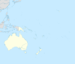
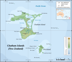
Waitangi (originally called Waiteki by Moriori) is the main port and largest settlement of the Chatham Islands. It is situated on along the southern shore of Petre Bay, on the west coast of the archipelago's main island. With a population of 177 in the 2018 census, Waitangi is by far the largest settlement on the archipelago, accounting for about 27% of the group's population of 663.

Contents

Geography

Waitangi is situated along the west coast of Chatham Island between the southern end of Waitangi Bay and the northern foothills of the island's southern plateau. The Nairn River flows north through the settlement before emptying into the bay. Lake Huro lies about 2 km (1.2 mi) to the east.

The town's antipode is the French town of Alzon. [3]

Climate

Waitangi experiences an oceanic climate with mild temperatures throughout the year. Precipitation can fall at any time throughout the year, with the highest percent of rain being centred during the winter.

Climate data for Waitangi, Chatham Islands
MonthJanFebMarAprMayJunJulAugSepOctNovDecYear
Mean daily maximum °C (°F)17.8
(64.0)
18.1
(64.6)
17.3
(63.1)
15.4
(59.7)
13.4
(56.1)
11.5
(52.7)
10.9
(51.6)
11.4
(52.5)
12.3
(54.1)
13.2
(55.8)
14.6
(58.3)
16.5
(61.7)
14.4
(57.9)
Daily mean °C (°F)14.8
(58.6)
15.1
(59.2)
14.4
(57.9)
12.5
(54.5)
10.5
(50.9)
8.8
(47.8)
8.0
(46.4)
8.6
(47.5)
9.5
(49.1)
10.6
(51.1)
11.9
(53.4)
13.7
(56.7)
11.5
(52.8)
Mean daily minimum °C (°F)11.9
(53.4)
12.2
(54.0)
11.5
(52.7)
9.7
(49.5)
7.6
(45.7)
6.2
(43.2)
5.2
(41.4)
5.8
(42.4)
6.7
(44.1)
8.0
(46.4)
9.3
(48.7)
11.0
(51.8)
8.8
(47.8)
Average precipitation mm (inches)52
(2.0)
56
(2.2)
85
(3.3)
74
(2.9)
90
(3.5)
93
(3.7)
109
(4.3)
79
(3.1)
68
(2.7)
56
(2.2)
53
(2.1)
71
(2.8)
886
(34.9)
Source: http://en.climate-data.org/location/475472/

Demographics

Waitangi is described as a rural settlement by Statistics New Zealand, and covers 4.86 km2 (1.88 sq mi). [1]

Historical population
YearPop.±% p.a.
2006189    
2013168−1.67%
2018177+1.05%
Source: [2]

Waitangi had a population of 177 at the 2018 New Zealand census, an increase of 9 people (5.4%) since the 2013 census, and a decrease of 12 people (-6.3%) since the 2006 census. There were 72 households. There were 81 males and 96 females, giving a sex ratio of 0.84 males per female. The median age was 43.7 years (compared with 37.4 years nationally), with 24 people (13.6%) aged under 15 years, 30 (16.9%) aged 15 to 29, 99 (55.9%) aged 30 to 64, and 21 (11.9%) aged 65 or older.

Ethnicities were 78.0% European/Pākehā, 66.1% Māori, 3.4% Pacific peoples, and 1.7% Asian (totals add to more than 100% since people could identify with multiple ethnicities).

Although some people objected to giving their religion, 47.5% had no religion, 37.3% were Christian and 3.4% had other religions.

Of those at least 15 years old, 15 (9.8%) people had a bachelor or higher degree, and 39 (25.5%) people had no formal qualifications. The median income was $36,100, compared with $31,800 nationally. The employment status of those at least 15 was that 90 (58.8%) people were employed full-time, 30 (19.6%) were part-time, and 0 (0.0%) were unemployed. [2]

Arts and culture

Kōpinga Marae (Moriori for "Grove of Kopi Trees") is a large meeting house that sits atop Te Awapatiki, the traditional meeting ground of the Moriori. The meeting house opened in January 2005 and serves as both a cultural centre and more generally as a community centre for the people of Waitangi. When viewed from above, the complex takes on the shape of an albatross. [4] [5] [6]

Administration and services

Waitangi is the seat of Chatham Islands Council, which provides local administration equivalent to those of New Zealand's unitary authorities. The council hosts a visiting District Court Judge, and is the base of a local police constable. A doctor and two nurses staff a four-bedroom hospital facility.

The settlement hosts two primary schools that are served by the Ministry of Education: Te One School and Kaingaroa School. Most continue their secondary education in New Zealand. [7] [8]

Local services in Waitangi include Port Waitangi and Fish Processing Factory, an ANZ Bank and Post Office, liquor store, general store, burger cafe, and a hotel and pub. Local volunteers run radio station Radio Weka and rebroadcast New Zealand television. Broadband and 4G mobile phone coverage are available through Spark, 2degrees and One NZ; through a RCG network, as well as satellite and ADSL broadband services.

See also

Related Research Articles

<span class="mw-page-title-main">Chatham Islands</span> Remote New Zealand archipelago

The Chatham Islands are an archipelago in the Pacific Ocean about 800 km (430 nmi) east of New Zealand's South Island. They are administered as part of New Zealand. The archipelago consists of about 10 islands within an approximate 60 km (30 nmi) radius, the largest of which are Chatham Island and Pitt Island (Rangiauria). They include New Zealand's easternmost point, the Forty-Fours. Some of the islands, formerly cleared for farming, are now preserved as nature reserves to conserve some of the unique flora and fauna.

<span class="mw-page-title-main">Moriori</span> Indigenous Polynesian people of the Chatham Islands

The Moriori are the indigenous Polynesian people of the Chatham Islands, New Zealand. Moriori originated from Māori settlers from the New Zealand mainland around 1500 CE. This was near the time of the shift from the archaic to classic Māori culture on the main islands of New Zealand. Oral tradition records multiple waves of migration to the Chatham Islands, starting in the 16th century. Over several centuries these settlers' culture diverged from mainland Māori, developing a distinctive language, mythology, artistic expression and way of life. Currently there are around 700 people who identify as Moriori, most of whom no longer live on the Chatham Islands. During the late 19th century some prominent anthropologists mistakenly proposed that Moriori were pre-Māori settlers of mainland New Zealand, and possibly Melanesian in origin.

<span class="mw-page-title-main">Waitangi, Northland</span> Locality in the Bay of Islands, North Island, New Zealand

Waitangi is a locality on the north side of the Waitangi River in the Bay of Islands, 60 kilometres north of Whangarei, on the North Island of New Zealand. It is close to the town of Paihia, to which it is connected by a bridge near the mouth of the Waitangi River estuary. While Statistics New Zealand and NZ Post consider the southern boundary of Waitangi to be the river and estuary, with the area further south being part of Paihia, the area by Te Tī Bay, immediately south of the river, is sometimes referred to as part of Waitangi.

<span class="mw-page-title-main">Tokomaru Bay</span> Town in the North Island of New Zealand

Tokomaru Bay is a small beachside community located on the isolated East Coast of New Zealand's North Island. It is 91 km north of Gisborne, on State Highway 35, and close to Mount Hikurangi. The district was originally known as Toka-a-Namu, which refers to the abundance of sandflies. Over the years the name was altered to Tokomaru Bay.

<span class="mw-page-title-main">Ngāpuhi</span> Māori iwi in New Zealand

Ngāpuhi is a Māori iwi associated with the Northland regions of New Zealand centred in the Hokianga, the Bay of Islands, and Whangārei.

<span class="mw-page-title-main">Matakana Island</span> Island in the Bay of Plenty, New Zealand

Matakana Island is located in the western Bay of Plenty in New Zealand's North Island. A long, flat barrier island, it is 20 kilometres (12 mi) in length but rarely more than 3 kilometres (1.9 mi) wide. The island has been continuously populated for centuries by Māori tribes that are mostly associated with Ngāi Te Rangi.

<span class="mw-page-title-main">Murupara</span> Town in the Bay of Plenty Region, New Zealand

Murupara is a town in the Whakatāne District and Bay of Plenty Region of New Zealand's North Island. The town is in an isolated part of the region between the Kaingaroa Forest and Te Urewera protected area, on the banks of the Rangitaiki River, 65 kilometres southeast of Rotorua. Indigenous Māori also make up over 90% of the population.

<span class="mw-page-title-main">Māhia Peninsula</span> Peninsula in Hawkes Bay, New Zealand

Māhia Peninsula is located on the east coast of New Zealand's North Island, in the Hawke's Bay region, between the towns of Wairoa and Gisborne.

<span class="mw-page-title-main">Ruatoria</span> Town in the Gisborne District of New Zealand

Ruatoria is a town in the Waiapu Valley of the Gisborne Region in the northeastern corner of New Zealand's North Island. The town was originally known as Cross Roads then Manutahi and was later named Ruatorea in 1913, after the Māori Master female grower Tōrea who had some of the finest storage pits in her Iwi at the time (Te-Rua-a-Tōrea). In 1925 the name was altered to "Ruatoria", although some texts retain the original spelling.

<span class="mw-page-title-main">Tolaga Bay</span> Town in Gisborne District, New Zealand

Tolaga Bay is both a bay and small town on the East Coast of New Zealand's North Island located 45 kilometres northeast of Gisborne and 30 kilometres south of Tokomaru Bay.

<span class="mw-page-title-main">Paihia</span> Town in Northland Region, New Zealand

Paihia is the main tourist town in the Bay of Islands in the Northland Region of the North Island of New Zealand. It is 60 kilometres north of Whangārei, located close to the historic towns of Russell and Kerikeri. Missionary Henry Williams named the mission station Marsden's Vale. Paihia eventually became the accepted name of the settlement.

<span class="mw-page-title-main">Frasertown</span> Settlement in Hawkes Bay Region, New Zealand

Frasertown is a small settlement in the northern Hawke's Bay Region of New Zealand's eastern North Island.

<span class="mw-page-title-main">Te Araroa (town)</span> Town in the Gisborne District of New Zealand

Te Araroa is a town in the Gisborne Region of the North Island of New Zealand. It is situated 175 km north of Gisborne city, along State Highway 35 between Tokata and Awatere. Te Araroa is the birthplace of noted Māori politician Sir Āpirana Ngata. Māori in the area are generally associated with the Ngāti Porou iwi. It is 100 metres from its local beach.

<span class="mw-page-title-main">Wharekahika</span> Town in Gisborne District, New Zealand

Wharekahika or Hicks Bay is a bay and coastal area in the Gisborne District of the North Island of New Zealand. It is situated 150 km east of Ōpōtiki and 186 km north of Gisborne city, along State Highway 35 between Potaka and Te Araroa.

<span class="mw-page-title-main">Ngāti Mutunga</span> Māori iwi in New Zealand

Ngāti Mutunga is a Māori iwi (tribe) of New Zealand, whose original tribal lands were in north Taranaki. They migrated from Taranaki, first to Wellington, and then to the Chatham Islands in the 1830s. The rohe of the iwi include Wharekauri, Te Whanga Lagoon and Waitangi on Chatham Island, and Pitt Island, also part of the Chatham Islands. The principal marae are at Urenui in Taranaki, and on the Chatham Islands.

Te Karaka is a small settlement inland from Gisborne, in the northeast of New Zealand's North Island. It is located in the valley of the Waipaoa River close to its junction with its tributary, the Waihora River. Te Karaka is located on State Highway 2, and is the largest settlement between Gisborne and Ōpōtiki in the Bay of Plenty.

<span class="mw-page-title-main">Māori people</span> Indigenous Polynesian people of New Zealand

Māori are the indigenous Polynesian people of mainland New Zealand. Māori originated with settlers from East Polynesia, who arrived in New Zealand in several waves of canoe voyages between roughly 1320 and 1350. Over several centuries in isolation, these settlers developed their own distinctive culture, whose language, mythology, crafts, and performing arts evolved independently from those of other eastern Polynesian cultures. Some early Māori moved to the Chatham Islands, where their descendants became New Zealand's other indigenous Polynesian ethnic group, the Moriori.

Kaingaroa, also called Kaingaroa Forest or Kaingaroa Village, is a small town southeast of Rotorua within the Bay of Plenty region of New Zealand's North Island. The town is the headquarters of Kaingaroa Forest.

<span class="mw-page-title-main">Moriori genocide</span> Invasion and killing of the Moriori people from 1835.

The Moriori genocide was the mass murder and enslavement of the Moriori people, the indigenous ethnic group of the Chatham Islands, by members of the mainland New Zealand iwi Ngāti Mutunga and Ngāti Tama from 1835 to 1863. The invaders murdered around 300 Moriori and enslaved the remaining population, causing the population to drop from 1,700 in 1835 to only 100 in 1870.

References

  1. 1 2 "ArcGIS Web Application". statsnz.maps.arcgis.com. Retrieved 26 November 2021.
  2. 1 2 3 "Statistical area 1 dataset for 2018 Census". Statistics New Zealand. March 2020. 7027635 (7027635). 2018 Census place summary: 7027635
  3. "From city life to the Chathams Islands: Why Helen Bint chose a life of isolation in remote New Zealand". thisNZlife. 10 May 2019. Retrieved 12 September 2021.
  4. "Te Kāhui Māngai directory". tkm.govt.nz. Te Puni Kōkiri.
  5. "Māori Maps". maorimaps.com. Te Potiki National Trust.
  6. "Kōpinga Marae". The Chatham Islands. Archived from the original on 3 January 2022. Retrieved 3 January 2022.
  7. "Te One School - About us". www.teone.school.nz. Retrieved 3 January 2022.
  8. "Kaingaroa School (Chatham Islands) | Education Review Office". ero.govt.nz. Retrieved 3 January 2022.