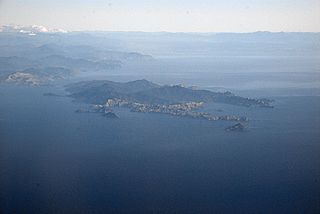
Rangitoto ki te Tonga / D'Urville Island is an island in the Marlborough Sounds along the northern coast of the South Island of New Zealand. It was named after the French explorer Jules Dumont d'Urville. With an area of approximately 150 square kilometres (58 sq mi), it is the eighth-largest island of New Zealand, and has around 52 permanent residents. The local authority is the Marlborough District Council.
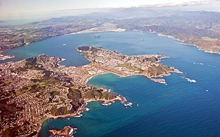
Porirua, a city in the Wellington Region of the North Island of New Zealand, is one of the four cities that constitute the Wellington metropolitan area; thus it is considered a part of Wellington as a whole. The name 'Porirua' is a corruption of 'Pari-rua', meaning "the tide sweeping up both reaches". It almost completely surrounds Porirua Harbour at the southern end of the Kapiti Coast. As of June 2021 Porirua had a population of 60,500.

Banks Peninsula is a peninsula of volcanic origin on the east coast of the South Island of New Zealand. It has an area of approximately 1,150 square kilometres (440 sq mi) and encompasses two large harbours and many smaller bays and coves. The South Island's largest city, Christchurch, is immediately north of the peninsula.

The Chatham Islands are an archipelago in the Pacific Ocean about 800 kilometres (500 mi) east of New Zealand's South Island, and has been part of New Zealand since 1841. The archipelago consists of about ten islands within an approximate 60-kilometre (37 mi) radius, the largest of which are Chatham Island and Pitt Island (Rangiauria). They include New Zealand's easternmost point, the Forty-Fours. Some of the islands, formerly cleared for farming, are now preserved as nature reserves to conserve some of the unique flora and fauna.
The Hutt Valley campaign is an armed conflict in the lower North Island of New Zealand between indigenous Māori and British settlers and military forces in 1846. The campaign was among the earliest of the 19th century New Zealand Wars that were fought over issues of land and sovereignty. It was preceded by the Wairau affray and followed by the Wanganui campaign and was triggered by much the same pressures—the careless land purchasing practices of the New Zealand Company, armed government support for settler land claims, and complex intertribal tensions between local Māori. The three conflicts also shared many of the same combatants.

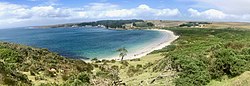
The Bay of Islands is an area on the east coast of the Far North District of the North Island of New Zealand. It is one of the most popular fishing, sailing and tourist destinations in the country, and has been renowned internationally for its big-game fishing since American author Zane Grey publicised it in the 1930s. It is 60 km (37 mi) north-west of the city of Whangarei. Cape Reinga, at the northern tip of the country, is about 210 km (130 mi) by road further to the north-west.

The Otago Peninsula is a long, hilly indented finger of land that forms the easternmost part of Dunedin, New Zealand. Volcanic in origin, it forms one wall of the eroded valley that now forms Otago Harbour. The peninsula lies south-east of Otago Harbour and runs parallel to the mainland for 20 km, with a maximum width of 9 km. It is joined to the mainland at the south-west end by a narrow isthmus about 1.5 km wide.

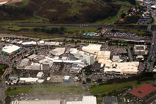
The suburb of Plimmerton lies in the northwest part of the city of Porirua in New Zealand, adjacent to some of the city's more congenial beaches. State Highway 59 and the North Island Main Trunk railway line pass just east of the main shopping and residential area.
Wellington Harbour is a large natural harbour on the southern tip of New Zealand's North Island. New Zealand's capital city, Wellington, is located on parts of its western and southern sides. Lower Hutt is located on parts of its northern and western sides.
Waitematā Harbour is the main access by sea to Auckland, New Zealand. For this reason it is often referred to as Auckland Harbour, despite the fact that it is one of two harbours adjoining the city. The harbour forms the northern and eastern coasts of the Auckland isthmus and is crossed by the Auckland Harbour Bridge. It is matched on the southern side of the city by the shallower waters of the Manukau Harbour.

The large Miramar Peninsula is on the southeastern side of the city of Wellington, New Zealand, at the entrance to Wellington Harbour, in Wellington's eastern suburbs. According to Māori legend, it was formed when the taniwha Whaitaitai beached as he tried to escape the confines of the harbour.

Taipa-Mangonui or Taipa Bay-Mangonui is a string of small resort settlements – Taipa, Cable Bay, Coopers Beach, and Mangonui – that lie along the coast of Doubtless Bay and are so close together that they have run together to form one larger settlement.

Te Awarua-o-Porirua Harbour, commonly known as Porirua Harbour, is a natural inlet in the south-western coast of the North Island of New Zealand.

Lyttelton Harbour / Whakaraupō is one of two major inlets in Banks Peninsula, on the coast of Canterbury, New Zealand; the other is Akaroa Harbour on the southern coast. It enters from the northern coast of the peninsula, heading in a predominantly westerly direction for approximately 15 kilometres (9.3 mi) from its mouth to the aptly-named Head of the Bay near Teddington. The harbour sits in an eroded caldera of the ancient Banks Peninsula Volcano, the steep sides of which form the Port Hills on its northern shore.

Mākaro/Ward island is one of the three small islands in Wellington Harbour, at the Southern end of the North Island, New Zealand.

Te Āti Awa is a Māori iwi with traditional bases in the Taranaki and Wellington regions of New Zealand. Approximately 17,000 people registered their affiliation to Te Āti Awa in 2001, with around 10,000 in Taranaki, 2,000 in Wellington and around 5,000 of unspecified regional location.
Whangaroa Harbour, previously spelled Wangaroa Harbour, is an inlet on the northern coast of Northland, New Zealand. Whangaroa Bay and the Pacific Ocean are to the north. The small settlements of Totara North and Saies are on the west side of the harbour, Waitaruke on the south side, and Whangaroa on the east. State Highway 10 runs through Waitaruke. The name comes from the lament "Whaingaroa" or "what a long wait" of a woman whose warrior husband had left for a foray to the south. The harbour was formed when rising sea levels drowned a river valley about 6,000 years ago. Steep outcrops remain from ancient volcanic rocks.

Ngāti Tama is a historic Māori iwi of present-day New Zealand which whakapapas back to Tama Ariki, the chief navigator on the Tokomaru waka. The iwi of Ngati Tama is located in north Taranaki around Poutama. The Mōhakatino river marks their northern boundary with the Tainui and Ngāti Maniapoto iwi. Titoki marks the southern boundary with Ngati Mutunga. The close geographical proximity of Tainui's Ngati Toa of Kawhia and Ngati Mutunga explains the long, continuous, and close relationship among the three Iwi.

Port Ross is a natural harbour on Auckland Island in the Auckland Islands Group, a subantarctic chain that forms part of the New Zealand Outlying Islands.

Te One is a settlement on the Chatham Islands. It is located in Petre Bay, on the west coast of the main island, just north of the port settlement of Waitangi.