
Narali is one of the oldest and largest towns of Gujar Khan Tehsil, Punjab province of Pakistan. Narali used to be the hub of trade before partition.It had a large Hindu population that dominated the trade circle.It still has a number of remains and ruins of Hindu culture & temples.It is culturally richer than the adjoining villages. Narali enjoys a very important position because it has union council office, patwarkhana, health centre and a post office.

Dalola is one of the 51 union councils (sub-divisions) of Abbottabad District in Khyber-Pakhtunkhwa province of Pakistan.
Sahang (ساهنگ) is a town in Gujar Khan Tehsil, Punjab, Pakistan. Raja Sajjad Sarwar is chairman of the union council. Sahang is also the chief town of Union Council Sahang which is an administrative subdivision of the Tehsil Sahang is one of the most biggest and important union councils of tehsil Gujar Khan. The notable tribes of this union council are Pakhral Rajpoot Minhas, Gakhars, Awan Malik, Dar, Rajput, Gujar, Bhatti, and Nagrial.

Dhurnal is a town and an administrative subdivision, of Chakwal District in the Punjab Province of Pakistan, it is part of Talagang Tehsil and is located at 32°47'60N 72°5'60E. Surrounded by Soon Valley from south, Thoa Mahram Khan from east, the greater Lawa from west and Kot Qazi, Mial, Laiti, Bidhar, Venhar etc. from north.

Ghungrila is a town in Gujar Khan Tehsil Punjab, Pakistan. Gungrila is also chief town of Union Council Gungrila which is an administrative subdivision of the Tehsil. It is located at 33°18'0"North, 73° 15' 0" East.
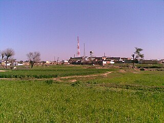
Jarmot Kalan is a town, Union council and administrative subdivision of Gujar Khan Tehsil in the Punjab Province of Pakistan.
Kaliam Awan is a town in Gujar Khan Tehsil in Rawalpindi district in the Pakistani province of Punjab. Kalyam Awan is the chief town of Union Council Kalyam Awan is an administrative subdivision of the Tehsil.
Kuri Dolal is a town in Gujar Khan Tehsil, Punjab, Pakistan. Kuri Dolal is also the chief town of Union Council Kuri Dolal, which is an administrative subdivision of the Tehsil. Mamoon Rashid Qureshi is the elected chairman of UC Kuri Dolal.
Punjgran Kalan is a town in Gujar Khan Tehsil Punjab, Pakistan. Punjgaran is also chief town of Union Council Punjgaran which is an administrative subdivision of the Tehsil,; and according to the 1998 census of Pakistan, the population of the Union Councils was 13,419.

Dhoong, part of Narali Union Council, is the second largest village in Gujar Khan Tehsil, Rawalpindi District, Punjab, Pakistan. Dhoong is a historic village of Rawalpindi District and noted for its reserves of oil and natural gas.
Gulyana is a town in Gujar Khan Tehsil, Punjab, Pakistan. Gulyana is also chief town of Union Council Gulyana which is an administrative subdivision of the Tehsil.
Kot Suleman is small part of village Dhoong near village Trati in Union Council Narali located in Gujar Khan Tehsil, District Rawalpindi, Punjab, Pakistan. Kot Suleman is a historic town of Village Dhoong, Rawalpindi District. Kot Suleman is famous for its natural reserves of oil and natural gas.
Noordolal or Noor Dolal is one of the oldest villages of Gujar Khan Tehsil, of the Rawalpindi District, Punjab, Pakistan. It was once a main shopping and activity centre of the local area having grocery shops, crockery shops, goldsmith shops, a Jama Masjid, one each boys and girls schools, and a post office.
Jherain is a village near the town of Mandrah in Tehsil Gujar Khan, District Rawalpindi, Pakistan. The village is at 5 km from the GT Road. Its population is approximately 30,000 inhabitants. Most of the people connected to farming. Wheat, peanut, barley and vegetables are major crops. A little majority are employed in government jobs. The village lacks of basic education and health facility. There is no college, dispensary or bazar. Although it has basic infrastructure of roads and streets. Pre-partition of Indo-Pak along with Muslims, Hindus and Sikhs also resided here. Social life of people depicts Muslim and Pakistani culture. A notable personality, Ch. Lall Khan, (Late) of this village struggle for the welfare of people. They established a Govt High School (Bhatta) and cemented many streets with the aid of local Government.

Kallar Syedan is a city in Punjab, Pakistan and the headquarters of the Kallar Syedan Tehsil.

Samote Union Council is a union council in Punjab, Pakistan.
Nirali Jabair is a village in the UC Changa Bangial, Gujar Khan Tehsil of Rawalpindi District, Punjab, Pakistan. Most of the population of the village is Gangal Awan


