Mali Beograd, Novi Sad

Last updated
Mali Beograd
Мали Београд
Urban neighnorhood

Mali beograd01.JPG

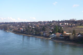
Panoramic view of Mali Beograd
Location map Novi Sad.jpg
Red pog.svg
Mali Beograd
Coordinates: 45°17′07″N19°50′29″E / 45.28528°N 19.84139°E / 45.28528; 19.84139 Coordinates: 45°17′07″N19°50′29″E / 45.28528°N 19.84139°E / 45.28528; 19.84139
CountryFlag of Serbia.svg  Serbia
Time zone CET (UTC+1)
  Summer (DST) CEST (UTC+2)

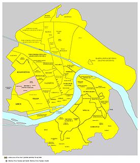
Mali Beograd is an urban neighborhood of the city of Novi Sad, Serbia. It is located on the northern bank of Danube-Tisa-Danube canal, between Vidovdansko Naselje and Oil Refinery. Large number of inhabitants of Mali Beograd are ethnic Roma.

Novi Sad City in Vojvodina, Serbia

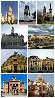
Novi Sad is the second largest city in Serbia, the capital of the autonomous province of Vojvodina and the administrative centre of the South Bačka District. It is located in the southern portion of the Pannonian Plain on the border of the Bačka and Srem geographical regions. Lying on the banks of the Danube river, the city faces the northern slopes of Fruška Gora.

Serbia Republic in Southeastern Europe

Serbia, officially the Republic of Serbia, is a country situated at the crossroads of Central and Southeast Europe in the southern Pannonian Plain and the central Balkans. The sovereign state borders Hungary to the north, Romania to the northeast, Bulgaria to the southeast, North Macedonia to the south, Croatia and Bosnia and Herzegovina to the west, and Montenegro to the southwest. The country claims a border with Albania through the disputed territory of Kosovo. Serbia's population is about seven million. Its capital, Belgrade, ranks among the oldest and largest citiеs in southeastern Europe.

Vidovdansko Naselje Urban neighborhood in South Bačka, Vojvodina, Serbia

Vidovdansko Naselje is an urban neighborhood of the city of Novi Sad, Serbia.

See also

Related Research Articles

Liman, Novi Sad Urban neighborhood in South Bačka, Vojvodina, Serbia

Liman is an urban neighborhood of the city of Novi Sad, Serbia. It is located to the south of the city centre, along the Danube river, covering an area of 3.98 km². It is a relatively new part of the city, built between 1960s and 1990s on what previously were marshes. It is divided into four parts, numbered by Roman numerals: Liman I, II, III and IV, which match the chronology of its development.

Grbavica (Novi Sad) Urban neighborhood in South Bačka, Vojvodina, Serbia

Grbavica is an urban neighborhood of the city of Novi Sad, Serbia.

Satelit

Satelit is an urban neighborhood of the city of Novi Sad, Serbia. In English it translates as “Benson”.

Stari Grad, Novi Sad Urban neighborhood in South Bačka, Vojvodina, Serbia

Stari Grad is an urban neighborhood of the city of Novi Sad, Serbia. It is the main part of Novi Sad, and it is also known as City Centre. In the Serbian language, the name "Stari Grad" means "Old Town".

Sajmište, Novi Sad Urban neighborhood in South Bačka, Vojvodina, Serbia

Sajmište is an urban neighborhood of the city of Novi Sad, Serbia.

Podbara Urban neighborhood in South Bačka, Vojvodina, Serbia

Podbara is an urban neighborhood of the city of Novi Sad, Serbia.

Adice Urban neighborhood in South Bačka, Vojvodina, Serbia

Adice is an urban neighborhood belonging to the city of Novi Sad, Serbia.

Salajka Urban neighborhood in South Bačka, Vojvodina, Serbia

Salajka, also known as Slavija, is an urban neighborhood of the city of Novi Sad, Serbia.

Slana Bara Urban neighborhood in South Bačka, Vojvodina, Serbia

Slana Bara is an urban neighborhood of the city of Novi Sad, Serbia.

Neighborhoods and suburbs of Novi Sad

This is a list of the neighbourhoods and suburbs of Novi Sad.

Šangaj Urban neighborhood in South Bačka, Vojvodina, Serbia

Šangaj is an urban neighborhood of the city of Novi Sad, Serbia. It is situated close to the Danube, and is completely surrounded by the Novi Sad industrial zones, right next to the oil refinery of Naftna Industrija Srbije. It covers an area of 0.13 km².

Ribnjak, Novi Sad Suburban settlement in South Bačka, Vojvodina, Serbia

Ribnjak is a small neighborhood of the city of Novi Sad, Serbia.

Veliki Rit, Novi Sad

Veliki Rit is an urban neighborhood of the city of Novi Sad, Serbia.

Industrial zones in Novi Sad

The City of Novi Sad Serbia has several industrial zones, which are, unlike non-industrial neighborhoods, mostly used for industrial purposes.

Bocke

Bocke is a neighborhood of the city of Novi Sad in Serbia.

Little War Island island

Little War Island or Malo ratno ostrvo or Horse Island or Konjsko ostrvo is a river island (ada) in Serbia, located at the mouth of the Sava river into the Danube. It is part of the Belgrade City proper, the capital of Serbia, and belongs to the municipality of Zemun.

Little Bačka Canal canal

Little Bačka Canal is a canal in Serbia which runs from Mali Stapar to Novi Sad. The canal is 66 km long and it is part of Danube-Tisa-Danube Canal system. The canal shortens waterway from Bezdan to Novi Sad by 75 km. Little Bačka Canal has 4 sluices. In the past, the canal was named after emperor Franz Josef and king Alexander.

Bačka Oblast Former oblast of Yugoslavia

Bačka Oblast was one of the oblasts of the Kingdom of Serbs, Croats and Slovenes from 1922 to 1929. Its administrative center was Novi Sad.

References