Sajlovo

Last updated
Sajlovo
Сајлово
Urban neighborhood
Sajlovo02.jpg
Sajlovo
Location map Novi Sad.jpg
Red pog.svg
Sajlovo
Location within Novi Sad
Coordinates: 45°16′30.51″N19°46′45.62″E / 45.2751417°N 19.7793389°E / 45.2751417; 19.7793389 Coordinates: 45°16′30.51″N19°46′45.62″E / 45.2751417°N 19.7793389°E / 45.2751417; 19.7793389
Country Flag of Serbia.svg  Serbia
Province Vojvodina
District South Bačka
Municipality Novi Sad
Area
  Total 3.69 km2 (1.42 sq mi)
Time zone UTC+1 (CET)
  Summer (DST) UTC+2 (CEST)
Area code +381(0)21
Car plates NS

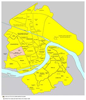
Sajlovo (Serbian Cyrillic : Сајлово; Hungarian : Zajol) or Donje Sajlovo (Serbian Cyrillic : Доње Сајлово) is a neighborhood of the city of Novi Sad, Serbia.

The Serbian Cyrillic alphabet is an adaptation of the Cyrillic script for the Serbian language, developed in 1818 by Serbian linguist Vuk Karadžić. It is one of the two alphabets used to write standard modern Serbian, Bosnian and Montenegrin, the other being Latin.

Hungarian language language spoken in and around Hungary

Hungarian is a Finno-Ugric language spoken in Hungary and several neighbouring countries. It is the official language of Hungary and one of the 24 official languages of the European Union. Outside Hungary it is also spoken by communities of Hungarians in the countries that today make up Slovakia, western Ukraine (Subcarpathia), central and western Romania (Transylvania), northern Serbia (Vojvodina), northern Croatia, and northern Slovenia. It is also spoken by Hungarian diaspora communities worldwide, especially in North America and in Israel. Like Finnish and Estonian, Hungarian belongs to the Uralic language family. With 13 million speakers, it is its largest member in terms of speakers.

Novi Sad City in Vojvodina, Serbia

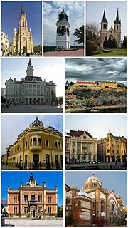
Novi Sad is the second largest city of Serbia, the capital of the autonomous province of Vojvodina and the administrative center of the South Bačka District. It is located in the southern part of the Pannonian Plain, on the border of the Bačka and Srem geographical regions. Bordering the banks of the Danube river, the city faces the northern slopes of Fruška Gora mountain.

Contents

History

In 1237, two villages with name Sajlovo (Hungarian: Zajol), Donje Sajlovo and Gornje Sajlovo, were mentioned to exist in this area. The original name of these settlements was Isailovo. Settlements were named after monk Isaija from nearby monastery that existed in the 12th century in the east of Rumenka. Name Sajlovo/Isailovo is of Slavic origin, which indicate that these settlements were initially inhabited by Slavs.

Rumenka Suburban settlement in South Bačka, Vojvodina, Serbia

Rumenka is a suburban settlement of the city of Novi Sad, Serbia. The village has a Serb ethnic majority and a population of 5,729 people.

Slavic languages languages of the Slavic peoples

The Slavic languages are the Indo-European languages spoken by the Slavic peoples. They are thought to descend from a proto-language called Proto-Slavic, spoken during the Early Middle Ages, which in turn is thought to have descended from the earlier Proto-Balto-Slavic language, linking the Slavic languages to the Baltic languages in a Balto-Slavic group within the Indo-European family.

Slavs Indo-European ethno-linguistic group living in Central Europe, Eastern Europe, Southeast Europe, North Asia and Central Asia

Slavs are an Indo-European ethno-linguistic group who speak the various Slavic languages of the larger Balto-Slavic linguistic group. They are native to Eurasia, stretching from Central, Eastern, and Southeastern Europe all the way north and eastwards to Northeast Europe, Northern Asia (Siberia), the Caucasus, and Central Asia as well as historically in Western Europe and Western Asia. From the early 6th century they spread to inhabit the majority of Central, Eastern and Southeastern Europe. Today, there is a large Slavic diaspora throughout North America, particularly in the United States and Canada as a result of immigration.

Modern settlement of Sajlovo was mostly settled during the 1990s with Serb refugees from parts of former Yugoslavia.

Borders

Map of the urban area of Novi Sad with city quarters, showing the location of Sajlovo Novi sad quarters.png
Map of the urban area of Novi Sad with city quarters, showing the location of Sajlovo
Medieval settlement of Donje Sajlovo in the location of modern Sajlovo Novi sad stara naselja02.png
Medieval settlement of Donje Sajlovo in the location of modern Sajlovo

The north-eastern border of Sajlovo is Rumenački put (Rumenka Road), the south-eastern border is ulica Donje Sajlovo (Donje Sajlovo Street), and the western border is a western city limit of Novi Sad.

Neighbouring city quarters

The neighbouring city quarters are : Jugovićevo in the south-east, and Industrijska Zona Jug in the north-east.

Jugovićevo

Jugovićevo is an urban neighborhood of the city of Novi Sad, Serbia.

See also

Related Research Articles

Liman, Novi Sad Urban neighborhood in South Bačka, Vojvodina, Serbia

Liman is an urban neighborhood of the city of Novi Sad, Serbia. It is located to the south of the city centre, along the Danube river, covering an area of 3.98 km². It is a relatively new part of the city, built between 1960s and 1990s on what previously were marshes. It is divided into four parts, numbered by Roman numerals: Liman I, II, III and IV, which match the chronology of its development.

Bistrica (Novo Naselje) Urban neighborhood in South Bačka, Vojvodina, Serbia

Bistrica, also known as Novo Naselje, is an urban neighborhood of the city of Novi Sad, Serbia.

Telep Urban neighborhood in South Bačka, Vojvodina, Serbia

Telep is an urban neighborhood of the city of Novi Sad, Serbia.

Grbavica (Novi Sad) Urban neighborhood in South Bačka, Vojvodina, Serbia

Grbavica is an urban neighborhood of the city of Novi Sad, Serbia.

Satelit

Satelit is an urban neighborhood of the city of Novi Sad, Serbia.

Stari Grad, Novi Sad Urban neighborhood in South Bačka, Vojvodina, Serbia

Stari Grad is an urban neighborhood of the city of Novi Sad, Serbia. It is the main part of Novi Sad, and it is also known as City Centre. In the Serbian language, the name "Stari Grad" means "Old Town".

Sajmište, Novi Sad Urban neighborhood in South Bačka, Vojvodina, Serbia

Sajmište is an urban neighborhood of the city of Novi Sad, Serbia.

Detelinara Urban neighborhood in South Bačka, Vojvodina, Serbia

Detelinara is an urban neighborhood of the city of Novi Sad, Serbia.

Rotkvarija (Žitni Trg)

Rotkvarija, also known as Žitni Trg, is an urban neighborhood of the city of Novi Sad, Serbia.

Veternička Rampa

Veternička Rampa is an urban neighborhood of the city of Novi Sad, Serbia.

Banatić Urban neighborhood in South Bačka, Vojvodina, Serbia

Banatić is an urban neighborhood of the city of Novi Sad, Serbia. Its name means "a little Banat".

Podbara Urban neighborhood in South Bačka, Vojvodina, Serbia

Podbara is an urban neighborhood of the city of Novi Sad, Serbia.

Adice Urban neighborhood in South Bačka, Vojvodina, Serbia

Adice is an urban neighborhood belonging to the city of Novi Sad, Serbia.

Avijatičarsko Naselje Urban neighborhood in South Bačka, Vojvodina, Serbia

Avijatičarsko Naselje, also known as Avijacija, is an urban neighborhood of the city of Novi Sad, Serbia.

Slana Bara Urban neighborhood in South Bačka, Vojvodina, Serbia

Slana Bara is an urban neighborhood of the city of Novi Sad, Serbia.

Gornje Livade, Novi Sad

Klisanski breg, also known as Gornje Sajlovo and Šumice, is an urban neighborhood of the city of Novi Sad, Serbia.

Neighborhoods and suburbs of Novi Sad

This is a list of the neighbourhoods and suburbs of Novi Sad.

History of Novi Sad

Novi Sad is the second largest city of Serbia. It began as a stone age settlement in present-day Petrovaradin. The Celts founded the first fortress at this location. During Roman rule, a larger fortress was built in the 1st century AD. It was devastated by the Huns in the 5th century and rebuilt by the Byzantines. The city passed through many other hands until being conquered by the Kingdom of Hungary. The city was first mentioned under the name Peturwarad or Petrovaradin in documents from 1237. It passed through the Ottoman Empire in the 16th century and the Habsburg Monarchy in the 17th.

Klisa, Serbia Urban neighborhood in South Bačka, Vojvodina, Serbia

Klisa is an urban neighborhood of the city of Novi Sad, Serbia.

References