Neighborhoods and suburbs of Novi Sad

Last updated
Map of the urban area of Novi Sad with city quarters Novi sad quarters.png
Map of the urban area of Novi Sad with city quarters
View of Stari Grad in winter Novi Sad square.jpg
View of Stari Grad in winter
Liman 3, NIS-NAFTAGAS building Liman002.jpg
Liman 3, NIS-NAFTAGAS building
Grbavica Grbavica02.jpg
Grbavica
Bistrica (Novo Naselje) Novo naselje11.jpg
Bistrica (Novo Naselje)
Detelinara Detelinara04.jpg
Detelinara
Telep Telep03.jpg
Telep
Petrovaradin Petrovaradin02.jpg
Petrovaradin
Sremska Kamenica SremskaKamenica01.jpg
Sremska Kamenica

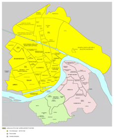
This is a list of the neighbourhoods and suburbs of Novi Sad .

Contents

Neighbourhoods on the left bank of the Danube

Neighbourhoods on the right bank of the Danube

Suburban settlements

Surrounding suburban settlements of Novi Sad CityNoviSad-map01.PNG
Surrounding suburban settlements of Novi Sad

Related Research Articles

<span class="mw-page-title-main">Petrovaradin</span> Town in Vojvodina, Serbia

Petrovaradin is a historic town in the Serbian province of Vojvodina, now a part of the city of Novi Sad. As of 2011, the urban area has 14,810 inhabitants. Lying on the right bank of the Danube, across the main part of Novi Sad, it is built around the Petrovaradin Fortress, the historical anchor of the modern city.

<span class="mw-page-title-main">Sremska Kamenica</span> Town in South Bačka, Serbia

Sremska Kamenica is a town and urban neighborhood of Novi Sad, in Serbia.

<span class="mw-page-title-main">Liman, Novi Sad</span> Urban neighborhood in South Bačka, Vojvodina, Serbia

Liman is an urban neighborhood of the city of Novi Sad, Serbia. It is located to the south of the city centre, along the Danube river, covering an area of 3.98 km2. It is a relatively new part of the city, built between 1960s and 1990s on what previously were marshes. It is divided into four parts, numbered by Roman numerals: Liman I, II, III and IV, which match the chronology of its development.

<span class="mw-page-title-main">Bistrica, Novi Sad</span> Urban neighborhood in South Bačka, Vojvodina, Serbia

Bistrica, also known as Novo Naselje, is an urban neighborhood of the city of Novi Sad, Serbia. Bistrica is one of the most populated urban areas of the city.

<span class="mw-page-title-main">Telep</span> Urban neighborhood in South Bačka, Vojvodina, Serbia

Telep is an urban neighborhood of the city of Novi Sad, Serbia.

<span class="mw-page-title-main">Satelit</span> Neighborhood of Novi Sad, Serbia

Satelit is a small urban neighborhood of the city of Novi Sad, Serbia. In English it translates as “Satellite”. It is part of the larger Bistrica urban area and neighborhood.

<span class="mw-page-title-main">Stari Ledinci</span> Suburban settlement in Petrovaradin, South Bačka, Serbia

Stari Ledinci also known simply as Ledinci is a suburban settlement of Petrovaradin, Novi Sad, Serbia.

<span class="mw-page-title-main">Bukovac, Novi Sad</span> Suburban settlement in Petrovaradin, South Bačka, Serbia

Bukovac is a suburban settlement of the city of Novi Sad, Serbia. It is located in Petrovaradin municipality.

<span class="mw-page-title-main">Kać</span> Selo in Vojvodina, Serbia

Kać is a suburban settlement of the city of Novi Sad, Serbia. The town had a population of 11,612 at the 2011 census.

<span class="mw-page-title-main">Slavija (Novi Sad)</span>

Slavija was one of the seven municipalities composing the city of Novi Sad between 1980 and 1989. The municipality included part of the city quarter of Rotkvarija, city quarters of Salajka, Pervazovo Naselje, Podbara, Vidovdansko Naselje, Slana Bara, Klisa, Mali Beograd, Veliki Rit, Šangaj, Radna Zona Sever 4 and Deponija, as well as the villages of Kać, Budisava, Kovilj and Čenej.

This is article about the infrastructure of Novi Sad.

<span class="mw-page-title-main">Religious architecture in Novi Sad</span>

Religious architecture in Novi Sad is very diverse. Majority of the believers in Novi Sad are from Serbian Orthodox Church, while others are from Roman Catholic Church, many Protestant churches, and Jewish community. Stari Grad is the place with the majority of churches and temples, and they were all built in the 18th and 19th century.

<span class="mw-page-title-main">History of Novi Sad</span>

Novi Sad is the second largest city of Serbia. It began as a Stone Age settlement in present-day Petrovaradin. The Celts founded the first fortress at this location. During Roman rule, a larger fortress was built in the 1st century AD. It was devastated by the Huns in the 5th century and rebuilt by the Byzantines. The city passed through many other hands until being conquered by the Kingdom of Hungary. The city was first mentioned under the name Peturwarad or Petrovaradin in documents from 1237. It passed through the Ottoman Empire in the 16th century and the Habsburg monarchy in the 17th.

<span class="mw-page-title-main">Ribnjak, Novi Sad</span> Suburban settlement in South Bačka, Vojvodina, Serbia

Ribnjak is a small neighborhood of the city of Novi Sad, Serbia.

<span class="mw-page-title-main">Klisa, Serbia</span> Urban neighborhood in South Bačka, Vojvodina, Serbia

Klisa is an urban area of the city of Novi Sad, Serbia.

<span class="mw-page-title-main">Industrial zones in Novi Sad</span>

The City of Novi Sad Serbia has several industrial zones, which are, unlike non-industrial neighborhoods, mostly used for industrial purposes.

<span class="mw-page-title-main">JGSP Novi Sad</span> Serbian public transport company

JGSP Novi Sad is a public transit company for the city of Novi Sad and is under the city's jurisdiction. The company conducts intercity lines for areas in Temerin, Žabalj, Sremski Karlovci, Inđija, Beočin, and Irig.

References

See also