
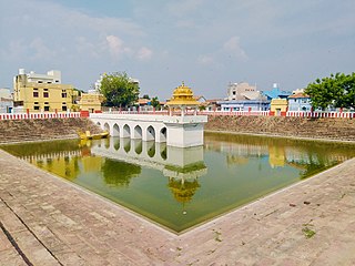
Karimnagar is also known as Elagandula is a city and District Headquarters in the Indian state of Telangana. Karimnagar is a major urban agglomeration and third largest city in the state. It is governed by the Municipal Corporation and is the headquarters of the Karimnagar district It is situated on the banks of Manair River, which is a tributary of the Godavari River. It is the third largest and fastest growing urban settlement in the state, according to 2011 census. It has registered a population growth rate of 45.46% and 38.87% respectively over the past two decades between 1991 and 2011, which is highest growth rate among major cities of Telangana. It serves as a major educational and health hub for the northern districts of Telangana. It is a major business center and widely known for its agricultural and granite industries, earning the nickname "City of Granites."

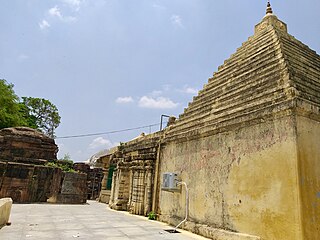
Vemulawada is an ancient historical and a famous pilgrimage census town in Rajanna Sircilla district of the Indian state of Telangana. It is the headquarters of Vemulawada Mandal and Revenue Division. The place is notable for Sri Raja Rajeswara Swamy temple,which is also known as “ Dakshinakashi” constructed between 760 and 973 CE, and a site of pilgrimage for Hindu worshipers. It also has ancient temples of Bheemeswara, Nagareswara and Pochamma nearby the main temple of Sri Raja Rajeswara Swamy. It was the capital of Vemulawada Chalukyas, that ruled present day Telangana, parts of Andhra Pradesh, Karnataka and Maharashtra between 7 and 10 century CE. The town attracts large number of pilgrims from South India as well as Maharashtra, Odisha and Chhattisgarh. Huge number of devotees throng the place during Maha Shivaratri and Sri Rama Navami. The famous floral festival of Telangana, Bathukamma is believed to have originated from this place.
Manthani is a municipal town in Manthani mandal in Peddapalli district of the Indian state of Telangana. It is located in Manthani mandal on the banks of the river Godavari..Manthani is nearest town of Godavarikhani, Ramagundam & Peddapalli.

Jagtial is a city in and the district headquarters of Jagtial district of Telangana state, India. Located about 190 kilometres (118 mi) north of the state capital Hyderabad, it has an average elevation of 293 metres (961 ft). In 2011 the population was about 104,000

Karimnagar district is one of the 33 districts of the Indian state of Telangana. Karimnagar city is its administrative headquarters. The district shares boundaries with Peddapalli, Jagityal, Sircilla, Siddipet, Jangaon, Hanamkonda district and Jayashankar Bhupalapally districts.

Nizamabad district is a district located in the north-western region of the Indian state of Telangana. The city of Nizamabad is the district headquarters. The district share boundaries with Jagtial, Sircilla, Nirmal, Kamareddy districts and with Nanded district of the state boundary of Maharashtra.
Jammikunta is a town and mandal in Karimnagar district of the state of Telangana, India. At the 2011 census it had a population of 32,645, 16,894 males and 15,751 females.

Huzurabad is a town in the Huzurabad mandal of Karimnagar district in the Indian state of Telangana. It is a municipality in the district. It is located about 41 kilometres (25 mi) from Karimnagar and 38 kilometres (24 mi) from Warangal.
Gollapally is a village located in Gollapalle mandal of Jagtial district in Telangana, India. Before the reorganisation of districts in Telangana, Gollapally was part of Karimnagar district. And in this village there is a river named ganga
Husnabad is a town in the Siddipet district of the Indian state of Telangana. It was a part of Karimnagar district before re-organisation of districts in the state. It is located in Husnabad mandal.
Saidapur is a village in Saidapur mandal of Karimnagar district in the state of Telangana in India, near Huzurabad.
Manakondur Assembly constituency is a SC reserved constituency of Telangana Legislative Assembly, India. It is one among 13 constituencies in Karimnagar district. It is part of Karimnagar Lok Sabha constituency.
Kondapalkala is a major panchayat village located in the district of Karimnagar, Telangana, India. It is located in Manakondur mandal. It is situated about 15 km from Lower Manair Dam, Karimnagar. It is reachable through road via 9 km from Chengerla which is on Karimnagar-Warangal State Highway.
Ippalapally is a village in Shankarapatnam mandal in Karimnagar district of Telangana State, India. It belongs to Telangana region. It is located 25 km towards South from District headquarters Karimnagar. 5 km from Shankarapatnam.

The Karimnagar Municipal Corporation is the local governing body, administering the city of Karimnagar in the Indian state of Telangana. It is the fourth most populous city in Telangana with a population of 260,899. The municipal corporation is headed by a mayor and democratically elected members.

Asifabad is a census town and the district headquarters of Kumuram Bheem district in the Indian state of Telangana. It is located in Asifabad mandal of Asifabad revenue division. It is situated on the banks of Peddavagu river. It is about 309 kilometres (192 mi) north of the state capital Hyderabad,86 kilometres (53 mi) from Ramagundam, 118 kilometres (73 mi) from Adilabad and 148 kilometres (92 mi) from Karimnagar.
Jagtial district is a district located in the northern region of the Indian state of Telangana. Its headquarters is Jagtial. The district shares boundaries with Nirmal, Mancherial, Karimnagar, Peddapalli, Sircilla and Nizamabad districts.
Pedapalli district is a district located in the northern region of the Indian state of Telangana. Its administrative headquarters is at Peddapalli and Commissionerate is at Ramagundam. The district shares boundaries with Mancherial, Karimnagar, Jagtial and Jayashankar Bhupalpally districts. This district covers Ramagundam city which is situated in the Godavari valley coalfields and has one of the India's largest thermal power stations in south region under NTPC. Mostly industries are connected with Godavarikhani - NTPC - Ramagundam.

Kothapalli (Haveli) (Telugu: కొత్తపల్లి), or Kothapalli, is a Revenue Village and a semi-town in Kothapalli Mandal, Karimnagar district, Telangana, India. The village used to be in the Karimnagar mandal of the old Karimnagar district. Following the district reorganization of Telangana, it was included in the newly formed Kothapalli Mandal. Kothapalli was formed as a municipal corporation on 2 August 2018, as part of the Municipal Amendment Bill by the Government of Telangana.

The Karimnagar Cable Bridge is a cable-stayed bridge in Karimnagar, Telangana, India. The bridge is located near the outskirts of Karimnagar town and is part of the National Highway 563 route.

