Built by the former Schuylkill Valley Division of the Pennsylvania Railroad, it is a large concreteopen spandrel arch bridge built in an "S curve," earning both the current concrete bridge and its 1883 wrought-iron-truss predecessor the nickname of "S-Bridge."[2] The bridge's challenging geometry was executed by T.L. Eyre, a Philadelphia contractor. Another notable feature is the saw-toothed construction joints along a 65-degree skew.[3]
In 1976, SEPTA purchased the bridge for its Ivy Ridge Line (now Cynwyd Line). Ten years later, after weather-related expansion and contraction of the bridge, and the shedding of pieces of concrete due to spalling, SEPTA closed the bridge on October 25, 1986, truncating service at Cynwyd and suspended service to three of the line's six stations (Ivy Ridge, West Manayunk, and Barmouth).[4] Between 1996 and 1999, the bridge was stabilized and refurbished.[5] The effort determined that the internal steel reinforcement was not compromised, as SEPTA had feared.[2] Further investigation by Urban Engineers determined that the bridge was safe and only needed surface work to stop the spalling.[2]
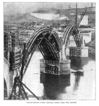
Aerial view of Manayunk Bridge, facing Lower Merion, showing the S curve.
SEPTA has not resumed service to Ivy Ridge; in 1996 low ridership led SEPTA to consider discontinuing service to Cynwyd altogether.[6]
Manayunk Bridge Trail
Between 2008 and June 2010, SEPTA removed all 2.5 miles (4.0km) of tracks north of Cynwyd for the Cynwyd Heritage Trail[7] and Ivy Ridge Rail Trail.[8]
Walkers on the Manayunk Bridge Trail in October 2015, shortly after the trail opened
On October 30, 2015, the ribbon was cut on the Manayunk Bridge Trail, a conversion of the bridge for use by people walking and bicycling. Designed by Whitman, Requardt & Associates, LLP, the trail features separate areas for walking and bicycling, along with a shared plaza in the center of the bridge that can be programmed for special events. Railings and fencing are in keeping with the historic industrial nature of the bridge.
↑ Veksler, Rafail; Thorat, Abhay P. (September 1999). "The Arch Bridge Mystery". Civil Engineering. 69 (9): 48–51.
↑ Williams, Gerry (1998). Trains, Trolleys & Transit: A Guide to Philadelphia Area Rail Transit. Piscataway, New Jersey: Railpace Company. p.84. ISBN978-0-9621541-7-1.
This page is based on this Wikipedia article Text is available under the CC BY-SA 4.0 license; additional terms may apply. Images, videos and audio are available under their respective licenses.