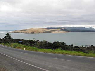
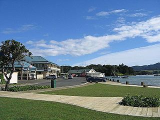
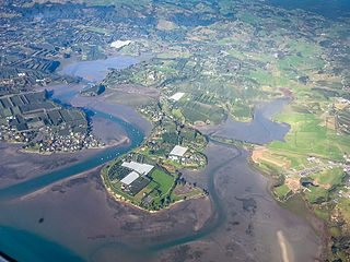
Mangawhai Heads is a township in Northland, New Zealand. Waipu is 21 kilometres northwest, and Mangawhai is 5 kilometres southwest. Mangawhai Heads is on the north shore of the Mangawhai Harbour.
The Mangawhai Cliffs Walkway, north of the township, is 4.5 kilometres long walk to Paepae-o-Tū / Bream Tail, and has a lookout point.[3][4][5]
Mangawhai Heads Beach is an intermediate-level surf beach.[6]
History
Mangawhai Museum
The Mangawhai Harbour is a part of the rohe of Te Uri-o-Hau, a tribal group either seen as an independent iwi, or as a hapū of Ngāti Whātua.[7] The name refers to Te Whai, a historic rangatira of Ngāti Whātua, who shares his name with the short-tail stingray, whai, found in the harbour.[7] Te Whai had a fortified pā at Mangawhai Point, a central headland in the harbour.[7]
Mangawhai Museum, opened in 2014,[8] features displays on the area's local history.[9][10]
Demographics
Mangawhai Heads covers 6.99km2 (2.70sqmi)[1] and had an estimated population of 2,800 as of June 2023,[11] with a population density of 401 people per km2.
Mangawhai Heads had a population of 1,995 at the 2018 New Zealand census, an increase of 756 people (61.0%) since the 2013 census, and an increase of 1,068 people (115.2%) since the 2006 census. There were 849 households, comprising 999 males and 999 females, giving a sex ratio of 1.0 males per female. The median age was 54.5 years (compared with 37.4 years nationally), with 306 people (15.3%) aged under 15 years, 195 (9.8%) aged 15 to 29, 831 (41.7%) aged 30 to 64, and 666 (33.4%) aged 65 or older.
Ethnicities were 91.1% European/Pākehā, 11.6% Māori, 2.6% Pacific peoples, 3.9% Asian, and 1.4% other ethnicities. People may identify with more than one ethnicity.
The percentage of people born overseas was 21.5, compared with 27.1% nationally.
Although some people chose not to answer the census's question about religious affiliation, 56.8% had no religion, 31.4% were Christian, 0.3% were Hindu, 0.2% were Muslim, 0.6% were Buddhist and 2.1% had other religions.
Of those at least 15 years old, 291 (17.2%) people had a bachelor's or higher degree, and 330 (19.5%) people had no formal qualifications. The median income was $27,300, compared with $31,800 nationally. 240 people (14.2%) earned over $70,000 compared to 17.2% nationally. The employment status of those at least 15 was that 612 (36.2%) people were employed full-time, 252 (14.9%) were part-time, and 45 (2.7%) were unemployed.[12]
Coromandel, also called Coromandel Town to distinguish it from the wider district, is a town on the Coromandel Harbour, on the western side of the Coromandel Peninsula, which is in the North Island of New Zealand. It is 75 kilometres east of the city of Auckland, although the road between them, which winds around the Firth of Thames and Hauraki Gulf coasts, is 190 km long. The population was 1,930 as of June 2023.
Kaipara District is a territorial authority district in the Northland Region of New Zealand.
Waiuku is a rural town in the Auckland Region of New Zealand. It is located at the southern end of the Waiuku River, which is an estuarial arm of the Manukau Harbour, and lies on the isthmus of the Āwhitu Peninsula, which extends to the northeast. It is 40 kilometres southwest of Auckland city centre, and 12 kilometres north of the mouth of the Waikato River.
Wellsford is a town on the Northland Peninsula in the northern North Island of New Zealand. It is the northernmost major settlement in the Auckland Region, and is 77 kilometres northwest of the Auckland CBD.
Parakai is a town in the North Island of New Zealand, sited 43 kilometres northwest of Auckland, close to the southern extremity of the Kaipara Harbour. Helensville is about 3 km (1.9 mi) to the south-east, and Waioneke is 22 km (14 mi) to the north-west.
Mōkau is a small town on the west coast of New Zealand's North Island, located at the mouth of the Mōkau River on the North Taranaki Bight. Mōkau is in the Waitomo District and Waikato region local government areas, just north of the boundary with the New Plymouth District and the Taranaki Region. Prior to 1989, the town was classed as being in Taranaki, and there is still a feeling that the community of interest is most associated with New Plymouth, 90 km to the southwest. State Highway 3 passes through the town on its route from Te Kūiti to Waitara and, eventually, New Plymouth.
Arapuni is a rural town centre on the Waikato river in the South Waikato District of New Zealand. The town sits next to the Arapuni Dam, a hydroelectric dam at Lake Arapuni commissioned in 1929. The Arapuni Power Station consists of eight turbines which give a total output of 196 MW, the largest of the power stations on the Waikato river. The Arapuni hydro station is owned and operated by Mercury Energy.
Nūhaka is a small settlement in the northern Hawke's Bay Region of New Zealand's eastern North Island, lying on State Highway 2 between Wairoa and Gisborne. The road to Mahia turns off the highway at Nūhaka.
Frasertown is a small settlement in the northern Hawke's Bay Region of New Zealand's eastern North Island.
Kaiwaka, known as "the little town of lights", is a settlement in Northland, New Zealand. The Kaiwaka River runs from the east through the area and joins with the Wairau River to form the Otamatea River, which drains into the Kaipara Harbour. State Highway 1 passes through Kaiwaka. Wellsford is 20 kilometres (12 mi) south, Brynderwyn is 8 kilometres (5.0 mi) north, and Whangārei, the closest city, is 60 kilometres (37 mi) to the north. The Mangawhai Heads are 18 kilometres (11 mi) northeast of Kaiwaka.
Mangawhai is a township at the south-west extent of the Mangawhai Harbour, or Mangawhai Estuary, in Northland, New Zealand. The adjacent township of Mangawhai Heads is 5 km north-east, on the lower part of the harbour. Kaiwaka is 13 km south-west, and Waipu is 20 km north-west of Mangawhai Heads.
Te Kōpuru is the largest community on the Pouto Peninsula in Northland, New Zealand. The Wairoa River separates the peninsula at this point from the main North Auckland Peninsula to the east. Dargaville is 14 km (8.7 mi) to the north.
Hihi or Hihi Beach is a village and rural community in the Far North District and Northland Region of New Zealand's North Island.
Rotoiti is a settlement on the shore of Lake Rotoiti, in Rotorua Lakes within the Bay of Plenty Region of New Zealand's North Island.
Mourea is a settlement in Rotorua Lakes within the Bay of Plenty Region of New Zealand's North Island.
Ōmāpere is a settlement on the south shore of Hokianga Harbour in Northland, New Zealand. State Highway 12 runs through Ōmāpere. Opononi is on the shore to the north of Ōmāpere.
Mangōnui is a settlement on the west side of Mangōnui Harbour in Northland, New Zealand. State Highway 10 runs through it. It is the easternmost of the Taipa-Mangonui string of settlements, separated from Coopers Beach to the northwest by Mill Bay Road.
Tuai is a village and rural community located around Lake Whakamarino, in the Wairoa District of the Hawke's Bay Region, on New Zealand's North Island.
Shelly Beach, officially known as Aotea / Shelly Beach, is a settlement and beach located on the eastern side of Te Korowai-o-Te-Tonga Peninsula and the southwest side of Kaipara Harbour, North Auckland. In 2018, a seawall and five groynes were constructed to fight erosion.
Plummers Point is a rural settlement in the Western Bay of Plenty District and Bay of Plenty Region of New Zealand's North Island. It is on a headland on the southern side of Tauranga Harbour, opposite Motuhoa Island, and between Mangawhai Bay and Te Puna Estuary. The East Coast Main Trunk forms its southern boundary.
This page is based on this Wikipedia article Text is available under the CC BY-SA 4.0 license; additional terms may apply. Images, videos and audio are available under their respective licenses.