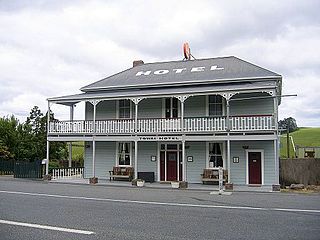
It consists of a primary school, pub (currently closed), Catholic Church (currently closed), petrol station (currently closed), marae, and a sports complex/community centre (open for meals fortnightly). The sports complex and community centre were destroyed by a fire in the early hours of January 16, 2020, but rebuilt and opened in September 2023.[1]
Kirikopuni and Pukehuia both had railway stations on the Dargaville Branch for the movement of stock throughout Northland and a passenger service.
History and culture
A Wesleyan mission station was set up by James Wallis in 1836,[2] and then run by James Buller.[3] The station lasted until 1853.[4] Kauri logs were sent down the river to be milled in the mid-1860s.[5] A flax mill operated in the late 19th century.[6]
A steamer service up the Wairoa River was established to Tangiteroria by the Tangihua in 1878, and Watson's Landing and store flourished there in 1881. The S.S. Blanche ran a service between Dargaville and Tangiteroria in 1891-2, and the S.S. Ethel was doing the run twice a week in 1896. It was replaced by the S.S. Naumai from 1903-1920. The service finished in 1929.[7] Road access was established in the 1890s.[8]
The SA1 statistical area had a population of 198 in the 2023 New Zealand census, a decrease of 6 people (−2.9%) since the 2018 census, and an increase of 30 people (17.9%) since the 2013 census. There were 105 males and 93 females in 87 dwellings.[14] 3.0% of people identified as LGBTIQ+. The median age was 46.9 years (compared with 38.1 years nationally). There were 33 people (16.7%) aged under 15 years, 36 (18.2%) aged 15 to 29, 90 (45.5%) aged 30 to 64, and 39 (19.7%) aged 65 or older.[13]
People could identify as more than one ethnicity. The results were 86.4% European (Pākehā), 22.7% Māori, 3.0% Pasifika, 1.5% Asian, and 3.0% other, which includes people giving their ethnicity as "New Zealander". English was spoken by 98.5%, Māori language by 4.5%, Samoan by 1.5%, and other languages by 3.0%. No language could be spoken by 3.0% (e.g. too young to talk). The percentage of people born overseas was 15.2, compared with 28.8% nationally.
The only religious affiliation given was 21.2% Christian. People who answered that they had no religion were 59.1%, and 16.7% of people did not answer the census question.
Of those at least 15 years old, 12 (7.3%) people had a bachelor's or higher degree, 105 (63.6%) had a post-high school certificate or diploma, and 39 (23.6%) people exclusively held high school qualifications. The median income was $38,000, compared with $41,500 nationally. 12 people (7.3%) earned over $100,000 compared to 12.1% nationally. The employment status of those at least 15 was that 87 (52.7%) people were employed full-time, 21 (12.7%) were part-time, and 3 (1.8%) were unemployed.[13]
Maungaru statistical area
Maungaru statistical area, which also includes Tangowahine, covers 691.81km2 (267.11sqmi)[11] and had an estimated population of 1,930 as of June 2024,[15] with a population density of 2.8 people per km2.
Historical population for Maungaru statistical area
Maungaru had a population of 1,836 in the 2023 New Zealand census, an increase of 36 people (2.0%) since the 2018 census, and an increase of 150 people (8.9%) since the 2013 census. There were 924 males, 900 females and 12 people of other genders in 687 dwellings.[18] 2.3% of people identified as LGBTIQ+. The median age was 44.6 years (compared with 38.1 years nationally). There were 327 people (17.8%) aged under 15 years, 309 (16.8%) aged 15 to 29, 840 (45.8%) aged 30 to 64, and 357 (19.4%) aged 65 or older.[17]
People could identify as more than one ethnicity. The results were 89.2% European (Pākehā); 24.7% Māori; 3.8% Pasifika; 3.3% Asian; 0.5% Middle Eastern, Latin American and African New Zealanders (MELAA); and 2.8% other, which includes people giving their ethnicity as "New Zealander". English was spoken by 97.5%, Māori language by 3.9%, Samoan by 0.5%, and other languages by 4.7%. No language could be spoken by 2.1% (e.g. too young to talk). New Zealand Sign Language was known by 0.3%. The percentage of people born overseas was 10.5, compared with 28.8% nationally.
Of those at least 15 years old, 126 (8.3%) people had a bachelor's or higher degree, 933 (61.8%) had a post-high school certificate or diploma, and 408 (27.0%) people exclusively held high school qualifications. The median income was $34,100, compared with $41,500 nationally. 108 people (7.2%) earned over $100,000 compared to 12.1% nationally. The employment status of those at least 15 was that 765 (50.7%) people were employed full-time, 249 (16.5%) were part-time, and 27 (1.8%) were unemployed.[17]
Education
Tangiteroria School is a coeducational full primary (years 1-8) school with a roll of 33 students as of August 2024.[19][20] The school was established in 1886.[21]
Tasman District is a local government district in the northwest of the South Island of New Zealand. It borders the Canterbury Region, West Coast Region, Marlborough Region and Nelson City. It is administered by the Tasman District Council, a unitary authority, which sits at Richmond, with community boards serving outlying communities in Motueka and Golden Bay / Mohua. The city of Nelson has its own unitary authority separate from Tasman District, and together they comprise a single region in some contexts, but not for local government functions or resource management (planning) functions.
Hauraki District is a territorial authority governed by the Hauraki District Council within the Waikato region of New Zealand. The seat of the council is at Paeroa.
Te Haumi is a settlement south-east of Paihia and north-west of Opua in the Bay of Islands area of Northland Region, New Zealand.
Westland District is a territorial authority district on the West Coast of New Zealand's South Island. It is administered by the Westland District Council. The district's population is 9,430.
Clutha District is a local government district of southern New Zealand, with its headquarters in the Otago town of Balclutha. Clutha District has a land area of 6,334.47 km2 (2,445.75 sq mi) and an estimated population of 19,300 as of June 2024. Clutha District occupies the majority of the geographical area known as South Otago.
Kamo is a northern suburb of the New Zealand city of Whangārei. The town's name was legally changed to Te Kamo in 2023. It is approximately five minutes' drive from the centre of Whangārei. There was coal mining in the area between 1875 and 1955, and it was known for its hot springs in the early years of the 20th century.
Towai is a locality in the Northland Region of the North Island of New Zealand. State Highway 1 passes through it. Kawakawa is 16 km northwest, and Whakapara is 17 km southeast. The North Auckland Line passes through Towai.
Horeke is a settlement in the upper reaches of the Hokianga Harbour in Northland, New Zealand. Kohukohu is just across the harbour. The Horeke basalts are located near the town, and can be viewed on an easy stroll through the Wairere Boulders, a commercial park.
Pukepoto is a town in Northland, New Zealand. It lies south west of Kaitaia and north east of Ahipara. The Herekino Forest lies to the south east.
Waikare is a locality in Northland, New Zealand. The Waikare River flows from the Russell Forest past Waikare and into the Waikare Inlet, which leads into the Bay of Islands.
Ruawai is a small town located 30 km south of Dargaville in Northland, New Zealand.
Rawhiti is a small beachfront town about 27km from Russell in the Bay of Islands of New Zealand.
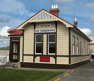
Matakohe is a settlement in Northland, New Zealand. The Matakohe River is a short river which runs from the north into the Arapaoa River, which is part of the Kaipara Harbour. State Highway 12 passes through Matakohe. Ruawai is 16 km to the west, and Paparoa is 6 km north east. The Hukatere Peninsula extends south into the Kaipara Harbour.
Paparoa is a settlement in Northland, New Zealand. The Paparoa Stream flows from the east, through the settlement, and into the Paparoa Creek to the south, which joins the Arapaoa River which is part of the Kaipara Harbour. State Highway 12 passes through Paparoa. Matakohe is 6 km to the south west, and Maungaturoto is 12 km east.
Tangowahine is a community on the northern Kaipara Harbour in Northland, New Zealand. The Tangowahine Stream flows from the Tutamoe Range east and then south to join the Wairoa River at Tangowahine. State Highway 14 passes through Tangowahine. Dargaville is 12 km to the south west, and Tangiteroria is 15 km north east.
Te Kōpuru is the largest community on the Pouto Peninsula in Northland, New Zealand. The Wairoa River separates the peninsula at this point from the main North Auckland Peninsula to the east. Dargaville is 14 km (8.7 mi) to the north.
Tinopai is a settlement on the Komiti Bay, part of the Hukatere Peninsula in the northern Kaipara Harbour in Northland, New Zealand. The Otamatea River flows from the north east past Tinopai and into the harbour. Matakohe is 23 km (14 mi) to the north.
Wairoa District is a territorial authority district within the Hawke's Bay Region in the North Island of New Zealand. The Wairoa District Council is headquartered in the largest town, Wairoa. The district covers the northern half of the Hawke's Bay coast, extending from Māhia Peninsula to Lake Waikaremoana, and south to the mouth of the Waikare River.
Taupō Bay is a bay, village and rural community in the Far North District and Northland Region of New Zealand's North Island. There are about 40 permanent residents, and 180 properties. The white sand beach is 1.5 km wide.
Takahue is a rural community in the Far North District and Northland Region of New Zealand's North Island, south of Kaitaia.
This page is based on this Wikipedia article Text is available under the CC BY-SA 4.0 license; additional terms may apply. Images, videos and audio are available under their respective licenses.