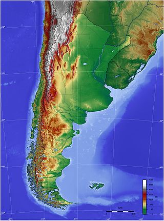
The geography of Argentina is heavily diverse, consisting of the Andes Mountains, pampas, and various rivers and lakes. Bordered by the Andes in the west and the South Atlantic Ocean to the east, its neighbouring countries are Chile to the west, Bolivia and Paraguay to the north, and Brazil and Uruguay to the northeast.

Río Negro is a province of Argentina, located in northern Patagonia. Neighboring provinces are from the south clockwise Chubut, Neuquén, Mendoza, La Pampa and Buenos Aires. To the east lies the Atlantic Ocean.

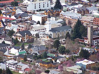
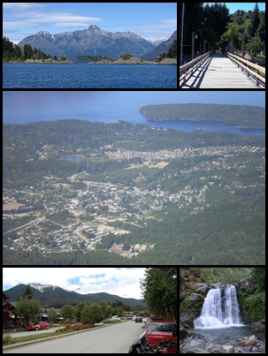
San Carlos de Bariloche, usually known as Bariloche, is a city in the province of Río Negro, Argentina, situated in the foothills of the Andes on the southern shores of Nahuel Huapi Lake. It is located within the Nahuel Huapi National Park. After development of extensive public works and Alpine-styled architecture, the city emerged in the 1930s and 1940s as a major tourism centre with skiing, trekking and mountaineering facilities. In addition, it has numerous restaurants, cafés, and chocolate shops. The city had a permanent population of 108,205 according to the 2010 census. According to the latest statistics from 2015, the population is around 122,700, and a projection for 2020 estimates 135,704.

Tronador is an extinct stratovolcano in the southern Andes, located along the border between Argentina and Chile, near the Argentine city of Bariloche. The mountain was named Tronador by locals in reference to the sound of falling seracs. With an altitude of 3,470 metres (11,380 ft), Tronador stands more than 1,000 m above nearby mountains in the Andean massif, making it a popular mountaineering destination. Located inside two national parks, Nahuel Huapi in Argentina and Vicente Pérez Rosales in Chile, Tronador hosts a total of eight glaciers, which are currently retreating due to warming of the upper troposphere.

Cerro Catedral is a mountain located 19 kilometres (12 mi) from San Carlos de Bariloche, and inside the Nahuel Huapí National Park, in Patagonia, Argentina.

Nahuel Huapi Lake is an Andean lake in the lake region of northern Patagonia between the provinces of Río Negro and Neuquén, in Argentina. The lake has a northwest-southeast elongated shape and complex geography with several branches, peninsulas and islands. The city of Bariloche is on the southern shore of the lake and the town of Villa La Angostura lies on its northwestern shores. The lake is wholly inside Nahuel Huapi National Park. It is one of the largest lakes in northern Patagonia. It is drained by Limay River and it is part of the watershed of Negro River which discharges into the South Atlantic.
San Martín de los Andes is a city in the south-west of the province of Neuquén, Argentina, serving as the administration centre of the Lácar Department. Lying at the foot of the Andes, on the Lácar lake, it is considered one of the main tourism destinations in the province. The National Route 40 runs to the city, connecting it with important touristic points in the south of the province, such as Lanín and Nahuel Huapí national parks.

Lake Puelo is a lake located in the northern part of Chubut Province, in Argentine Patagonia. Of fluvial-glacial origin, its deepest point is 180 meters. The narrow L-shaped lake is surrounded by Lago Puelo National Park.

The Limay River is an important river in the northwestern Argentine Patagonia. It originates at the eastern end of the Nahuel Huapi Lake and flows in a meandering path for about 380 kilometres (240 mi), collecting the waters of several tributaries, such as the Traful River, the Pichileufú and the Collón Curá. It then meets the Neuquén River and together they become the Río Negro. At this confluence lies the city of Neuquén.
Villa La Angostura is a town located in the Los Lagos Department in the south of the Argentine province of Neuquén, on the northwest shore of the Nahuel Huapi Lake.

Lake Todos los Santos is a lake located in the Los Lagos Region of southern Chile, 96 km northeast of the regional capital Puerto Montt and 76 km east of Puerto Varas, within the boundaries of the Vicente Pérez Rosales National Park. It has a surface area of 178.5 km² and a maximum depth of 337 m. The Lake's National Park status has ensured protection to its environment. The catchment is largely covered with old-growth Valdivian temperate rain forests. The present form of the lake is the result of glacial and volcanic processes.

The Puelo River has its origin in Lake Puelo in Argentine, and flows north-west through the Andes into Chile and the Reloncaví Estuary of the Reloncaví Sound at the northern end of the Gulf of Ancud.

The Gutiérrez River is a small river in the northwestern Argentine Patagonia. It is born at the northern end of the Gutiérrez and flows in a rect path for about 4 kilometres (2.5 mi) and ends on the Nahuel Huapi Lake.

Nahuel Huapi National Park is the oldest national park in Argentina, established in 1922 as Parque Nacional de Sud and reconfiguered in 1934. It surrounds Nahuel Huapi Lake in the foothills of the Patagonian Andes. The largest of the national parks in the region, it has an area of 7,050 km2 (2,720 sq mi), or nearly 2 million acres. Its landscapes represent the north Patagonian Andean Zone consisting of three types, namely, the Altoandino, the Andino-Patagónico and the Patagonian steppe. It also represents small parts of the Valdivian Rainforest.

Nicolás Mascardi was a Ligurian Jesuit priest and missionary in South America in the 17th century. He arrived to Chile in 1651. While active in Araucanía he gained notoriety for the exorcisms he practised among the Mapuches.

Mascardi Lake is in the lake region of northern Patagonia in Río Negro Province of Argentina. The lake is near the resort city of Bariloche and is within the Nahuel Huapi National Park. The lake, of glacial origin, is named after Nicolás Mascardi, a 17th-century Jesuit who was a missionary in the area.

Modesta Victoria is a passenger ship which travels on the Nahuel Huapi Lake inside the National Park of the same name in Río Negro, Argentina.
Valle El Manso is a valley in the Andes of Río Negro Province, Argentine Patagonia. Located in the vicinity of Chile it was settled in the late 19th century by Chileans of mestizo and Mapuche stock as well by European immigrants. Chiloé Archipelago in particular was the place of origin of most Chilean settlers. Early settlers engaged in subsistence farming. The valley was used to move cattle from the interior of Patagonia to the ports in the Pacific.

Cerro Otto is a mountain located 5 kilometres (3.1 mi) from San Carlos de Bariloche, and inside the Nahuel Huapí National Park, in Patagonia, Argentina.


