Mascardi Lake

Last updated
Mascardi Lake
Lago Mascardi.jpg
Location Bariloche Department, Río Negro Province, Argentina, in Patagonia
Coordinates 41°20′54″S71°33′49″W / 41.34833°S 71.56361°W / -41.34833; -71.56361 Coordinates: 41°20′54″S71°33′49″W / 41.34833°S 71.56361°W / -41.34833; -71.56361
Primary inflows Manso River
Primary outflows Manso River
Basin  countries Argentina
Max. length 15 kilometres (9.3 mi)
Max. width 2.5 kilometres (1.6 mi)
Surface area 39.2 square kilometres (15.1 sq mi)
Average depth 111 metres (364 ft)
Max. depth 218 metres (715 ft)
Water volume 4.35 cubic kilometres (3,530,000 acre⋅ft)
Residence time 3.72 years
Surface elevation 750 metres (2,460 ft)
Settlements Villa Mascardi
References [1]

Mascardi Lake (Spanish : Lago Mascardi, Spanish pronunciation:  [ˈlaɣo masˈkaɾði] ) is in the lake region of northern Patagonia in Río Negro Province of Argentina. The lake is near the resort city of Bariloche and is within the Nahuel Huapi National Park. The lake, of glacial origin, is named after Nicolás Mascardi, a 17th-century Jesuit who was a missionary in the area.

Spanish language Romance language

Spanish or Castilian is a Romance language that originated in the Castile region of Spain and today has hundreds of millions of native speakers in the Americas and Spain. It is a global language and the world's second-most spoken native language, after Mandarin Chinese.

Patagonia Region of South America

Patagonia is a sparsely populated region at the southern end of South America, shared by Chile and Argentina. The region comprises the southern section of the Andes mountains and the deserts, pampas and grasslands to the east. Patagonia is one of the few regions with coasts on three oceans, with the Pacific Ocean to the west, the Atlantic Ocean to the east, and the Southern Ocean to the south.

Río Negro Province Province of Argentina

Río Negro is a province of Argentina, located at the northern edge of Patagonia. Neighboring provinces are from the south clockwise Chubut, Neuquén, Mendoza, La Pampa and Buenos Aires. To the east lies the Atlantic Ocean.

Contents

Tronador stratovolcano looms over one arm of the lake. Cerro tronador desde lago mascardi 01b.jpg
Tronador stratovolcano looms over one arm of the lake.
The road along Catedral arm. The small lake is Lake Llum. Lagos Mascardi y Llum desde Cerro Latzina (1987) - panoramio.jpg
The road along Catedral arm. The small lake is Lake Llum.

Description

Mascardi Lake is V-shaped with two arms roughly equal in length and width. The eastern arm is called the Catedral (Cathedral) arm and the western arm is called the Tronador arm, named after the volcano on the border with Chile which is the highest and most prominent mountain in the area. The lake is surrounded by mountains rising steeply from the lake to elevations of more than 1,800 metres (5,900 ft). The mountains are snow-capped most of the year. Timberline on the mountains is above 1,600 metres (5,200 ft). [2] The lake has a maximum depth of 218 metres (715 ft) and a surface area of 39.2 square kilometres (9,700 acres) [3]

Tronador mountain

Tronador is an extinct stratovolcano in the southern Andes, located along the border between Argentina and Chile, near the Argentine city of Bariloche. The mountain was named Tronador by locals in reference to the sound of falling seracs. With an altitude of 3,470 m, Tronador stands more than 1000 m above nearby mountains in the Andean massif, making it a popular mountaineering destination. Located inside two National Parks, Nahuel Huapi in Argentina and Vicente Pérez Rosales in Chile, Tronador hosts a total of eight glaciers, which are currently retreating due to warming of the upper troposphere.

Tree line edge of the habitat at which trees are capable of growing

The tree line is the edge of the habitat at which trees are capable of growing. It is found at high elevations and high latitudes. Beyond the tree line, trees cannot tolerate the environmental conditions. The tree line is sometimes distinguished from a lower timberline or forest line, which is the line below which trees form a forest with a closed canopy.

The primary inflow into Mascardi Lake is the Manso River which emerges from a small lake fed by a glacier called the Ventisquero Negro (literally "black snowfield"), on the slopes of Tronador mountain about 20 kilometres (12 mi) west of the lake. The Manso emerges from the southwestern corner lake via a short, turbulent passage called "Los Rapidos" (The Rapids) which leads to the Las Moscas Lake, the next in a chain of lakes along the Manso River. [4]

Manso River (Argentina and Chile) river in Argentina

The Manso River is a river of Rio Negro Province of Argentina and Los Lagos Region of Chile, both part of Patagonia. The Manso River is located in the Andes. It follows a winding route through snow-capped mountains and connects many glacial lakes. The Manso flows generally southward until its confluence with the Puelo River in Chile. The river while in Argentina flows through the Nahuel Huapi National Park. Most of the southern part of Nahuel Huapi is in the drainage basin of the Manso River.

In Spanish language a ventisquero is a zone in a mountain where heavy snow accumulations occur. Before the term glaciar became widespread many glaciers in Patagonia were titled with ventisquero, such as Ventisquero Negro or Grandes Ventisqueros.

A paved highway (National Route 40) extends down the eastern arm of the lake to the southern shore where a small community called Villa Mascardi is located. From there a road (unpaved in 2018) named Route 82 follows the western arm of the lake northward and continues on to Ventisquero Negro. [5]

Villa Mascardi is a village and municipality in Río Negro Province in Argentina. It is named after the 17th century Jesuit Nicolás Mascardi who was active in the Nahuel Huapi area. Villa Mascardi lies at the shores of Mascardi Lake.

Recreation

Kayaking and fishing are popular on Mascardi Lake with a number of tourist agencies in Bariloche offering guided tours. [6] Species sought by fisherman are rainbow, brown, and brook trout, none of them native to Argentina. A number of campgrounds and lodging places are found along the roads that encircle one-half the lake. One of the campgrounds on the northernmost part of the Catedral arm is owned by a community of Mapuche people who were the principal occupants of this area from the 17th until the late 19th century. [7]

Rainbow trout species of trout

The rainbow trout is a trout and species of salmonid native to cold-water tributaries of the Pacific Ocean in Asia and North America. The steelhead is an anadromous (sea-run) form of the coastal rainbow trout(O. m. irideus) or Columbia River redband trout (O. m. gairdneri) that usually returns to fresh water to spawn after living two to three years in the ocean. Freshwater forms that have been introduced into the Great Lakes and migrate into tributaries to spawn are also called steelhead.

Brown trout species of brown trout

The brown trout is a European species of salmonid fish that has been widely introduced into suitable environments globally. It includes both purely freshwater populations, referred to as the riverine ecotype, Salmo trutta morpha fario, and a lacustrine ecotype, S. trutta morpha lacustris, also called the lake trout, as well as anadromous forms known as the sea trout, S. trutta morpha trutta. The latter migrates to the oceans for much of its life and returns to fresh water only to spawn. Sea trout in the Ireland and Britain have many regional names: sewin in Wales, finnock in Scotland, peal in the West Country, mort in North West England, and white trout in Ireland.

Brook trout species of fish

The brook trout is a species of freshwater fish in the char genus Salvelinus of the salmon family Salmonidae. It is native to Eastern North America in the United States and Canada, but has been introduced elsewhere in North America, as well as to Iceland, Europe, and Asia. In parts of its range, it is also known as the eastern brook trout, speckled trout, brook charr, squaretail, or mud trout, among others. A potamodromous population in Lake Superior, as well as an anadromous population in Maine, is known as coaster trout or, simply, as coasters. The brook trout is the state fish of nine U.S. states: Michigan, New Hampshire, New Jersey, New York, North Carolina, Pennsylvania, Vermont, Virginia, and West Virginia, and the Provincial Fish of Nova Scotia in Canada.

A hiking trail, a section of the long-distance Huella Andina trail, leads 19.5 kilometres (12.1 mi) south to Lake Steffen. The trail is rated moderate in difficulty. [8]

Related Research Articles

The geography of Argentina describes the geographic features of Argentina, a country located in southern South America. Bordered by the Andes in the west and the South Atlantic Ocean to the east, neighboring countries are Chile to the west, Bolivia and Paraguay to the north, and Brazil and Uruguay to the northeast.

Tourism in Argentina

Argentina is provided with a vast territory and a huge variety of climates and microclimates ranging from tundra and polar in the south to the tropical climate in the north, through a vast expanse of temperate climate and natural wonders like the Aconcagua, the highest mountain in the world outside the Himalayas, the widest river and estuary of the planet, the huge and very mighty Iguazú Falls, some of the flattest and wide meadows-plains of planet Earth, culture, customs and gastronomies famous internationally, a higher degree of development, good quality of life and people and relatively well prepared infrastructure make this country one of the most visited of America.

Bariloche City in Río Negro, Argentina

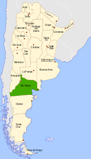
San Carlos de Bariloche, usually known as Bariloche, is a city in the province of Río Negro, Argentina, situated in the foothills of the Andes on the southern shores of Nahuel Huapi Lake. It is located within the Nahuel Huapi National Park. After development of extensive public works and Alpine-styled architecture, the city emerged in the 1930s and 1940s as a major tourism centre with skiing, trekking and mountaineering facilities. In addition, it has numerous restaurants, cafés, and chocolate shops. The city has a permanent population of 108,205 according to the 2010 census.

Cerro Catedral Mountain in Argentina

Cerro Catedral is a mountain located 19 kilometres (12 mi) from San Carlos de Bariloche, and inside the Nahuel Huapí National Park, Patagonia, Argentina.

Huechulafquen Lake

Huechulafquen Lake is a lake in Neuquén Province, Patagonian Argentina. This glacial lake is located in the Andean mountains in Lanín National Park some 25 kilometres from Junín de los Andes and 60 kilometres from San Martín de los Andes. It is one of Argentina's largest Andean lakes and is fed by glacier and meltwater streams and lakes.

Puelo Lake lake in Argentina

Lake Puelo is a lake located in the northern part of Chubut Province, in Argentine Patagonia. Of fluvial-glacial origin, its deepest point is some 180 meters below the water level. The narrow L-shaped lake is surrounded by Lago Puelo National Park.

Puelo River river in Chile and Argentina

The Puelo River has its origin in Lake Puelo in Argentine, and flows north-west through the Andes into Chile and the Reloncaví Estuary of the Reloncaví Sound at the northern end of the Gulf of Ancud.

Aluminé Lake lake in Argentina

Aluminé Lake is a large and deep lake located in the Andes in the western part of Neuquén Province, Argentina, near the border with Chile. Aluminé Lake is fed by the outflow of Lake Moquehue and is the source of the Aluminé River whose waters ultimately reach the Atlantic Ocean. The tourist town of Villa Pehuenia is on the northern shore of the lake.

San Carlos de Bariloche Airport international airport serving San Carlos de Bariloche, Rio Negro, Argentina

San Carlos de Bariloche Airport, also known as Teniente Luis Candelaria Airport, is an international airport serving the city of San Carlos de Bariloche, Río Negro, Argentina. The airport covers an area of 1,810 hectares and has a 12,000-square-metre (130,000 sq ft) terminal; it is located 13 kilometres (8.1 mi) out of the city.

Futalaufquen Lake lake

Futalaufquen Lake is a large lake in Chubut Province, Argentina. Futalaufquen Lake is in the chain of lakes of the Futaleufú River system of Argentina which via Yelcho Lake and the Yelcho River flows into the Pacific Ocean in Chile. Located in the Andes, Lake Futalaufquen is three-lobed, of glacial origin, and occupies narrow valleys between glaciated peaks. It is located in the Andes within Los Alerces National Park. The name comes from the Mapuche language. "Futa" means great, and "laufquen" means lake.

Otto Meiling German mountain climber

Otto Meiling (1902–1989) was a German-born mountaineer who achieved many first ascents in Nahuel Huapi National Park and the surrounding area.

Nahuel Huapi National Park national park

Nahuel Huapi National Park is the oldest national park in Argentina, established in 1934. It surrounds Nahuel Huapi Lake in the foothills of the Patagonian Andes. The largest of the national parks in the region, it has an area of 7,050 km2 (2,720 sq mi), or nearly 2 million acres. Its landscapes represent the north Patagonian Andean Zone consisting of three types, namely, the Altoandino, the Andino-Patagónico and the Patagonian steppe. It also represents small parts of the Valdivian Rainforest.

Marcos Couch Rocky Rock

Marcos José Couch, Argentinean mountain climber, known for his professional achievements in mountains such as the Shishapangma in Tibet, or the Fitz Roy in Patagonia. Since 1987 he is a mountain guide and has been working internationally.

Lake Cholila

Lake Cholila is a lake in Chubut Province, Argentina. Lake Cholila is the uppermost of several large lakes in the Futaleufú River system of Argentina that via Yelcho Lake and the Yelcho River flows into the Pacific Ocean in Chile. The lake is of glacial origin and occupies a narrow east to west valley between glaciated peaks of the Andes.

Lake Rivadavia lake in Argentina

Lake Rivadavia is a lake in Chubut Province, Argentina. Lake Rivadavia is the second lake, after Lake Cholila, in the chain of lakes in the Futaleufú River system of Argentina which via Yelcho Lake and the Yelcho River flows into the Pacific Ocean in Chile. Located in the Andes, Lake Rivadvia is of glacial origin and occupies a narrow north to south valley between glaciated peaks. All the lake except the northern tip is in the Los Alerces National Park. Argentina Provincial Highway 71 follows the eastern coast of the lake. Development consists only of a few campgrounds near the highway.

Lake Menéndez lake in Argentina

Lake Menéndez is a large lake in Chubut Province, Argentina. Lake Menéndez is in the chain of lakes in the Futaleufú River system of Argentina which via Yelcho Lake and the Yelcho River flows into the Pacific Ocean in Chile. Located in the Andes, Lake Rivadvia is Y-shaped, of glacial origin, and occupies two narrow valleys between glaciated peaks. The lake is in the Los Alerces National Park. There are no roads or other developments near the lake. Travel is by boat or foot. Lake Menéndez is noted for the extensive Alerce (Fitzroya) forests near the tips of its two arms.

Amutui Quimey Lake is a large reservoir in Chubut Province, Argentina. Amutui Quimey is in the chain of lakes of the Futaleufú River system of Argentina which via Yelcho Lake and the Yelcho River flows into the Pacific Ocean in Chile. The Futaleufú dam was completed and the reservoir filled in 1976 and the lake occupies a narrow valley between glaciated peaks. They hydroelectric facility produces 2.6 million megawatts per year, most of which is used for an aluminum refinery in the city of Puerto Madryn. Amutui Quimey Lake is in the Andes within Los Alerces National Park. The name of the lake comes from the Mapuche language. It means "lost beauty", referring to the beauty of the valley before the lake.

References