
Dodoma Region is one of Tanzania's 31 administrative regions. The regional capital is the city of Dodoma. Dodoma is located in central Tanzania, bordered by Singida region to the west, Manyara region to the north, Iringa region to the south, and Morogoro region to the east. Dodoma region hosts the nation's capital city, where the legislative assembly of Bunge is based. Dodoma region also hosts one of the largest universities in Tanzania: University of Dodoma. The region is the home of the Tanzanian wine industry, which is the second largest wine industry on the continent after South Africa. According to the 2022 national census, the region had a population of 3,085,625; in the 2012 national census, the population was 2,083,588.

Singida Region is one of Tanzania's 31 administrative regions. The region covers a land area of 49,340 km2 (19,050 sq mi). The region is comparable in size to the combined land area of the nation state of Slovakia. The Region is bordered to the north by Shinyanga Region, Simiyu Region and Arusha Region, to the northeast by Manyara Region, to the east by Dodoma Region, to the southeast by Iringa Region, to the southwest by Mbeya Region and to the west by Tabora Region. The regional capital is the municipality of Singida. According to the 2022 national census, the region had a population of 2,008,058.

Shinyanga Region is one of Tanzania's 31 administrative regions. The region covers a land area of 18,555 km2 (7,164 sq mi). The region is comparable in size to the combined land area of the nation state of Fiji. The region is bordered to the north by the Mwanza, Mara, and Kagera Regions and to the south by the Tabora Region. In addition, the Kigoma Region borders the region to the west, and the Simiyu Region and a sliver of Singida Region to the east. The regional capital is the municipality of Shinyanga. According to the 2022 national census, the region had a population of 2,241,299.

Tabora Region is one of Tanzania's 31 administrative regions. The regional capital is the municipality of Tabora. The region is located in mid-western part of Tanzania. Tabora is bordered by Shinyanga to the north, Singida to the east, Mbeya and Songwe to the south. lastly, Katavi, Kigoma and Geita, border Tabora to the west. Tabora is by far the largest region in Tanzania by area. Most of the population in the region is concentrated in the north in Nzega district. According to the 2022 national census, Tabora Region had a population of 3,391,679.

Meatu District is one of the five districts of the Simiyu Region of Tanzania. It is bordered to the north by the Itilima District, to the west by the Maswa District and Shinyanga Region to the east by the Arusha Region, to the southeast by the Manyara Region and to the south by the Singida Region. Its district capital is the town of Mwanhuzi.
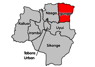
Igunga is one of the seven districts of the Tabora Region of Tanzania. It is bordered to the north by the Shinyanga Region, to the east by the Singida Region, to the south by the Uyui District and to the west by the Nzega District. Its administrative seat is the town of Igunga. Igunga is now divided by two Constituencys: Igunga Constituency and Manonga Constituency, whereby Manonga town is Choma Chankola. Igunga is the second district in production

Sikonge District is one of the seven districts of the Tabora Region of Tanzania. The town of Sikonge is the administrative seat. The district has an area of 27,873 square kilometres (10,762 sq mi), but 26,834 square kilometres (10,361 sq mi) of it is in forest and game reserves. It is bordered to the northwest by Urambo District, to the north by Uyui District, to the east by Manyoni District of Singida Region, to the south by Chunya District of Mbeya Region, and to the southwest by Mlele District of Katavi Region.

Hanang District is one of the six districts of the Manyara Region of Tanzania. It is bordered to the north by the Mbulu District and Babati Rural District, to the southeast by the Dodoma Region and to the southwest by the Singida Region. Mount Hanang is located within the boundaries of the district.

Ikungi District is one of the six districts of the Singida Region of Tanzania. It is one of the 20 new districts that were formed in Tanzania since 2010; it was split off from Singida Rural District. Ikungi District is bordered to the north by Iramba District, Singida Urban District and Singida Rural District, to the east by Manyara Region, to the south by Manyoni District and to the west by Tabora Region. Its administrative seat is the town of Ikungi.

Singida Urban District is one of the six districts of the Singida Region of Tanzania. It is bordered to the south and west by the Ikungi District and to the north and east by the Singida Rural District. Its administrative seat is the town of Singida.
Itigi is a town in central Tanzania. It is located in Itigi District of the Singida Region.
Makanda is an administrative ward in the Manyoni District of the Singida Region of Tanzania. In 2016 the Tanzania National Bureau of Statistics report there were 10,718 people in the ward, from 9,768 in 2012.
Makuru is an administrative ward in the Manyoni District of the Singida Region of Tanzania. In 2016 the Tanzania National Bureau of Statistics report there were 13,029 people in the ward, from 11,874 in 2012.
Manyoni is an administrative ward in the Manyoni District of the Singida Region of Tanzania. In 2016 the Tanzania National Bureau of Statistics report there were 27,986 people in the ward, from 25,505 in 2012.
Nkonko is an administrative ward in the Manyoni District of the Singida Region of Tanzania. In 2016 the Tanzania National Bureau of Statistics report there were 12,378 people in the ward, from 11,281 in 2012.
Manyoni is a town in central Tanzania. It is the district headquarter of Manyoni District.

Singida Rural District is one of the six districts of the Singida Region of Tanzania. It is bordered to the north by Mkalama District, to the east by Manyara Region and Dodoma Region, to the south by Ikungi District and to the west by Singida Urban District. Its administrative seat is the town of Singida.
Singida is a city in central Tanzania. The city is the location of the regional headquarters of Singida Region as well as the district headquarters of Singida Urban District. The region and district are named after the city.

Bahi District is one of the seven districts of the Dodoma Region of Tanzania. Bahi District is bordered to the north by Chemba District, to the east by Dodoma District and Chamwino District, and to the west by Singida Region. Its administrative seat is the town of Bahi.

Itigi District is a district council in the Singida Region of central Tanzania established in 2015. The district lies in the south-western portion of the Singida Region with 279,069 people and encompasses a large area mostly made up of protected game reserves.
